…but first Barbara’s “Newfoundland to Phoenix and All Points In Between” rock collection minus a big bag of big rocks from Quartzsite…


January, 2019
As we drove toward Joshua Tree National Park,two questions caused us some intrigue: “what is a joshua tree and how did it get its name?” and “why is this a national park?” There are so many national parks and so many more national monuments that the differentiation between a National Park and National Monument is unclear. For example why is White Sands a monument and the Guadalupe Mountains a park? Honestly, we’d classify these the other way around. Maybe it really doesn’t matter; is it all in the perception of the beholder?
After spending a day in Joshua Tree National Park the reason the Park deserves the protection and preservation afforded by the National Park Service is pretty clear. Joshua Trees only exist in the Mojave Desert. The Saguaro, Ocotillo and Cholla Cactus only exist in the Sonoran Desert. The Mojave and Sonoran Desert ecosystems intersect within the 1,235 square miles of the Park, and nowhere else – hence a National Park!

To figure out what a Joshua Tree is, imagine a twisted, spiky tree straight out of Dr. Seuss! Easy right? However, the name Joshua Tree was given by a group of Mormon settlers who crossed the Mojave Desert in the mid-19th century. The unique shape reminded them of a Biblical story in which Joshua reaches his hands up to the sky in prayer.

The Joshua Tree, Yucca Brevifolia, is a member of the Agave family, a subgroup of flowering plants that also includes grasses and orchids. (Agave? don’t they make tequila out of agave?).

Years ago the Joshua Tree was recognized by American Indians for its useful properties: tough leaves were worked into baskets and sandals, and flower buds and raw or roasted seeds made a healthy addition to the diet.
Joshua Tree National Park is not just about the trees or yucca. It’s about rock formations to climb and in which to see different “faces,” and it’s about great hiking up, around and through those rock formations, and to a pristine lake.


As we traveled from Quartzsite to San Diego we unexpectedly passed sand dunes and promised ourselves we would return. The Imperial Sand Dunes Recreation Area is located from the very southeast corner of California and stretches almost to Yuma, Arizona.

The Imperial Sand Dunes are the largest mass of sand dunes in the state, and they were formed by windblown sands of ancient Lake Cahuilla. The dune system extends for more than 40 miles in a band averaging 5 miles wide. Dunes often reach heights of 300 feet above the desert floor, providing a favorite place for off-highway vehicle (OHV) enthusiasts. The dunes also offer fabulous scenery, opportunities for solitude, and a home to rare plants and animals.
We found the Dunes to be amazingly beautiful, loved seeing the OHVs motoring their ups and downs, and enjoyed our hiking in this otherworldly environment.


Slab City is a free campsite and alternative living community located near an active bombing range in the desert city of Niland, California. Previously an old WWII base, Marine barracks Camp Dunlap, the campsite earns its name for the concrete slabs that remained long after the military base had been bulldozed and abandoned.

The permanent residents, also known as “slabbers,” most often end up here for the feeling of freedom that comes with living in an uncontrolled, off-the-grid area in the middle of the desert. There is no incorporation, government, taxes or laws. With no electricity, fresh water, or sewage treatment, residents are forced to rely on solar panels and their own waste system. The residents share one communal shower, a concrete cistern that is fed by a hot spring 100 yards away. The whole concept of Slab City gave Barbara the creeps!


Perhaps the community’s most popular slabber was Leonard Knight, the creator of Salvation Mountain. For over twenty years, Knight lived out of his truck and worked continually on his colorful art “mountain,” which marks the entrance to Slab City.


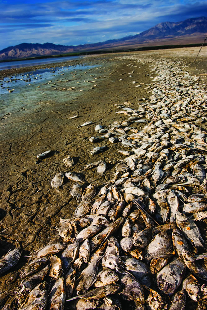
The Salton Sea is a shallow, saline, endorheic rift lake* located directly on the San Andreas Fault, covering 350 square miles predominantly in California’s Imperial and Coachella Valleys. Its water is twice as salty as the Pacific Ocean (!), and its surface is 236 feet below sea level; the deepest point of the sea is only 5 feet higher than the lowest point of Death Valley (!). The Sea was a productive fishery during the 40s, and with post-war wealth became a popular tourist spot in the 50s with resorts, beach-front homes, and water skiing, seeing the likes of regulars like Sonny Bono and the Beach Boys. But the incredible salinity of the lake and the heavy agriculture of Southern California slowly destroyed the ecosystem. Runoff from farms polluted the sea, and most of the fish species could not survive; migratory birds were poisoned with botulism and other lethal bacteria. Currently the banks of the Salton Sea are vivid, surreal empty landscapes littered with dead fish and other detritus of human habitation. This is just weird enough to make us wish we could have explored another half day.


The Sonny Bono Salton Sea National Wildlife Refuge is located in the southeast corner of the Salton Sea and just a brief distance from Slab City. The Refuge is located within the Pacific Flyway, an important resting and wintering place along the migration route for birds.


Barbara and Brian
* An endorheic rift lake “is a limited drainage basin that normally retains water and allows no outflow to other external bodies of water, such as rivers or oceans, but converges instead into lakes or swamps, permanent or seasonal, that equilibrate through evaporation.”

I got my science lesson for the day, and I’m so pleased to learn something new. Thanks, as always, for sharing your travels. I would’ve been a bit spooked, I think, by the desert, especially the various face-like rocks … and you’re right that your picture of the water reflecting the surrounding stones is just breathtaking.
LikeLike
Gloria, I appreciate that you always take the time to send along a comment about our blogs…a quick question though: are we putting too much fact/science in the blogs and not enough of our take on the places we visit? The reason I’m asking is that my daughter mentioned that she thought the text is getting boring. Brian
LikeLike
I do really love hearing what both of you are enjoying (or not!) in particular, but I also appreciate the information. I think it’s great that you’re sharing what you’re learning as you go (although maybe you two together already had a lot of the information on hand?). Just keep it up, so I can continue with my vicarious living!!
LikeLike
It’s not getting boring it’s just long for someone who doesn’t like to read much, unless it’s Fart Squad, Dork Diaries, or Good Night Gorilla. I do love my shout outs though and tell you what where are those $.50 hot dog and pop wagons these days?
LikeLike
Thanks for the clarity…and i don’t know where the cheapee hot dog wagons are. I remember them for 25 cents-yum
LikeLike
Thanks for the clarity, Elyssa. I remember the cheapee hot dogs at 25 cents!
LikeLike
Now those are some blue skies! I loved my trip to those areas. Imperial Sand Dunes was what I always thought the desert would actually look like. Please tell me when you were in Slab City you made it to East Jesus and when you were bumming around the Salton Sea you made it for a beer at the Ski Inn.
LikeLike
Hey Rich…made it to East Jesus, but unfortunately not a beer at the Ski Inn. I was disappointed, but we flat out ran out of time.
LikeLike
I figured the folk art in East Jesus would be to your tastes – Slab City / Salton Sea is definitely a unique place. The towns around Salton Sea look post apocalyptic. Those blue skies in your pics are killing me – makes me want to hang it up and move out West pronto!
LikeLike
There’s plenty of blue sky for everyone…come west, young man!
LikeLike