
August – September, 2019
In 2018 the unduplicated count of visitors to America’s National Parks was 318 million, and coming in at number 7 of the top 10 is The Grand Canyon. In total 6.3 million visitors explored the Park, and visiting the South Rim (5 million or so visitors) has always been far more popular than visiting the North Rim (fewer than 1 million visitors). One of the reasons given for the difference in the number of visitors is due to the difficulty of reaching the North Rim; the road is only open from the snow melt somewhere around the middle to the end of June until the accumulation of ice and snow in September or early October makes the roadway too dangerous for travel by mere mortal passenger vehicles and pickup trucks. But in our opinion the real reasons for the difference in the number of visitors between the North and South Rim are: better South Rim merchandising (tours, hotels/accommodations, mule rides); the views from the North Rim are not as universally spectacular as at the South Rim (where it’s hard to have a bad view); there are wonderful hiking trails that can be enjoyed by novice and expert hikers alike from the South Rim; and if a full descent and ascent is on the agenda, the South Rim is much more doable. Brian made a friend in Mesa who has on more than 1 occasion descended into the Canyon, enjoyed a 3-day camping trip and hike between the 2 Rims, and then ascended out of the Canyon. He clearly stated that the degree of difficulty either descending or ascending at the North Rim is prohibitive for all but the most experienced and “in-shape” hiker.
It’s probably not known by everyone who decides to visit The Grand Canyon that there are actually 4 entrance stations: the North Rim; the South Rim entrance bringing visitors to The Grand Canyon Visitors Center and Mather Point; the Desert View East Entrance which affords different views of the South Rim, and the West Entrance located on Hualapai tribal lands. Annually a little more than half a million visitors see the Park from the West Entrance.
We weren’t overly enthusiastic or in awe of The Grand Canyon following our visit to the North Rim last June. It was cool – sure – but fell far below our excellence standard. We thought at the time that maybe, just maybe we were spoiled by Zion and Bryce Canyon, Lake Powell and Antelope Canyon, the Vermillion Cliffs and Grand Escalante National Monument, and the natural beauty we experienced all around Kanab, Utah. The wow factor just wasn’t there.
It’s approximately 14 miles from the North Rim to Bright Angel Campground and another 7-9 miles to the trailheads at the South Rim. We wondered whether or not the South and West Rims of The Grand Canyon would be impressive, great, glorious, magnificent, monumental, splendid, august, striking, outstanding, superb or something else? Would the adventures we would have and what we would see from entering the Park from the South Visitors Center and Mather Point, Desert View East, and West Entrances prove to us why this was The GRAND Canyon? Would we enjoy hikes in the Park? Would we be assaulted by wranglers, mules and their riders? Would squirrels carry off our lunches? Would the views of the Canyon at sunrise and sunset be as cool as we imagined them to be? This ain’t multiple choice, nor Graham’s True or False game…the answers are yes, yes, yes, no, no, and yes.
Enjoy…
53 miles north of Williams and 7 miles south of The Grand Canyon Visitors Center is the resort town of Tusayan (population 558). Tusayan is a staging station for visitors to the National Park, and honestly, the town is so far off of the main line that unless you want to be pretty much away from anything else there’s no reason to stay in town except for rest and refueling before and after a visit The Grand Canyon.
We arrived at the South Rim Visitors Center and couldn’t help but notice the crowd moving, almost in unison past the building itself as they followed the signs to Mather Point. Mather Point, named honoring Stephen Tyng Mather the first director of the National Park Service, serves as a great introduction to the Canyon. The scale and immensity of the chasm left us awestruck.


One of the easier hikes in the Park is from Mather Point (2.1 miles) to Grand Canyon Village – the hike is paved and has almost no elevation change. 0.70 miles into the hike we found ourselves at Yavapai Point.


The Rim Trail from Yavapai Point to Grand Canyon Village is referred to as the Trail of Time. In addition to magnificent views, all along the trail are signs that provide time line information about the formation of The Canyon. Examples of the beautiful rock layers you actually see arrayed before you are on display…Mother Nature at her best!


Our first day at the South Rim of Grand Canyon National Park turned out to be stunning and remarkable. There was so much more yet to encounter.
The Desert View Entrance to the Park is 49 miles north of Flagstaff on Highway 89 and then 33 miles west of Cameron on Route 64. About 5 miles or so west of Cameron we stumbled across the Little Colorado River Gorge, and it was pretty easy to give into our urge to stop, stretch our legs and check it out…


On property a family of Hopi were selling handmade jewelry, and Barbara did score some beautiful bracelets for our older granddaughters.
Upon arriving at the Desert View parking lot we were met by a murder of the ever-ubiquitous (is that redundant?) crows fighting over the right to perch in the bed of a pickup truck. Curiously it didn’t look like they were searching for something in the bed – they were just hanging out.

Desert View Watchtower stands at the East entrance to the park and sits on the edge of the Grand Canyon. Designed by Mary Colter (remember the La Posada Hotel and the Hopi House at Grand Canyon Village?) and completed in 1932, it is a stone tower built as a monument to the Puebloan people. From the tower you can see the Colorado River and miles of the Grand Canyon.


Desert View Drive winds its way 21 miles from Desert View to the South Rim Visitor Center. Along the way we were able to stop at Lipan Point, Moran Point, Buggeln, and Grandview Point in order to have more sensational views of the Canyon and the Colorado River. Each location was about 4-5 miles from the other.


We were glad (sic) to get up well before dawn in order to make our way in darkness (it is awfully dark in the high desert heading north out of Williams) to the Park to then hike along the Mather Point overlook 100 feet east of the South Rim Grand Canyon Visitors Center to join together with a hundred or so of our closest friends to watch the glory of sunrise over the Grand Canyon. Breathtaking!


Yaki Point is a short distance from the Visitors Center and the trailhead for the South Kaibab Trail. South Kaibab is one of the two main trails on the South Rim of Grand Canyon National Park; the other is Bright Angel (more on this trail later). It is a 7.1 mile hike with a 4800-foot descent from the trailhead to Bright Angel Campground at the base of the South Rim of the Grand Canyon. The general rule of thumb is that it takes twice as long to ascend as it does to descend, and it is imperative to take enough water and salty snacks to make the trip. Planning smartly and accordingly is a requirement, and the roundtrip is only doable with overnight camping. Campgrounds fill-up months and months in advance.
Day hikes still require planning, water and salty snacks, and it is much more reasonable to pick one of 4 locations along the trail as a turnaround point. Roundtrip hikes of 3, 6, 8.8 or 9.2 miles are possible; descents/ascents are 1200, 2000, 3200 and 3600 feet respectively. We chose to hike 6-miles with a 2000-foot descent/ascent to and from the trailhead to Skeleton Point.


The Grand Canyon’s West Rim is located on land owned by the Hualapai Nation. The Tribe operates the site, and there is an entry fee which can be more or less depending on what you’d like to do.
We chose the basic entry package which included a free shuttle bus to all attractions, including visiting a replica Wild West Town aptly named Hualapai Ranch…


…a short walking tour to replicas of Hualapai dwellings…

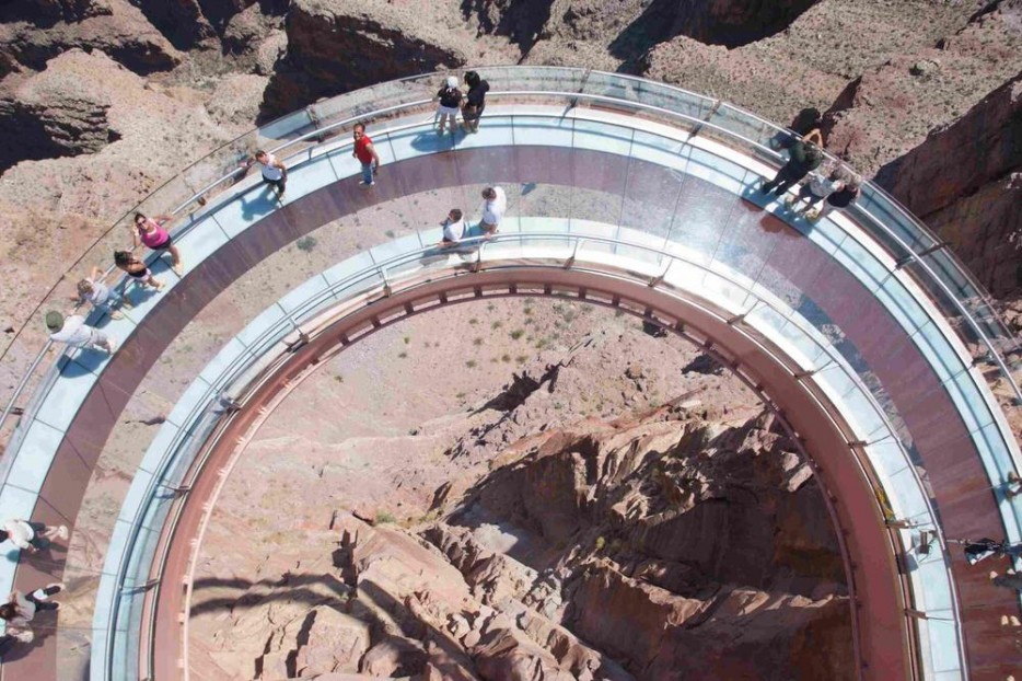
…and the Grand Canyon Skywalk…


The Grand Canyon Skywalk at Eagle Point is a horseshoe-shaped cantilever bridge with a glass walkway. USGS topographic maps show the elevation at The Skywalk’s location as 4,770 feet, the elevation of the Colorado River in the base of the canyon as 1,160 feet, and the vertical drop directly under The Skywalk as between 500 – 800 feet.
So in we trotted to a staging area…hospital booties were provided for us to put over our shoes and lockers to hold all the worldly belongings we brought with us. The booties stop scratches from occurring on the glass and, I suppose, affording a cleaning service for the glass as well. And nothing is permitted to be carried onto the viewing deck…would clumsy individuals inadvertently drop their valuable belongings over the edge? Would nefarious persons sabotage The Skydeck with hidden C-4 or other explosives? Or would cameras and cell phone cameras reduce the number of picture packages sold by Hualapai photographers? You be the judge!
It was pretty easy to walk along the edge of the walkway, hold onto the railing and to look down into the Canyon…the perception we felt is just like any other when standing on the edge of a precipice and looking at an angle downward. But to walk in the middle of the glass walkway was fairly disconcerting and disorienting at first. When walking in the middle – on the glass walkway – we found ourselves shuffling our feet – not striding – then taking teeny tiny baby steps, as our gaze had to be focused ahead and not down (Barbara’s always trying to get me to walk with my head up – this was good practice!). Looking down through the glass 500-800 feet to the canyon floor caused vertigo that persisted unless we stood still! Eventually our visual-perceptive field attenuated to the situation, and we could slowly (!) move back and forth along the glass walkway while looking down. We were lucky this occurred for us as other visitors experienced immobilizing terror if on the walkway too long. Brian was able to provide aid for several of our fellow tourists needing a sturdy arm and calming words to transverse the bridge in its entirety and to get back on solid ground. It was fun to hang out on The Skywalk, take a good long look around and down, and eventually be able to block out what our brain screamed was a dangerous place to walk.
While The Skywalk is the main attraction, there is short trail along the West Canyon Rim that, along with views from The Skywalk, afforded wonderful vistas of this part of The Grand Canyon.


On the way back to the campground we passed through a stretch of road running through the middle of a desert, and although the temperature was approaching 110 degrees, Brian had to get a couple of pictures of a small Joshua Tree forest.


The Bright Angel Trailhead is approximately 0.50 miles from Hopi House, and it is a terrific hike into The Grand Canyon. It’s a 17.7 mile out and back hike descending 5,006 feet (5,820 feet is a mile!) from the trailhead to the banks of the Colorado River and the Bright Angel Campground. It is the most heavily trafficked trail in the park, and it requires a back country permit if hiking beyond the 3-mile rest house; the Rangers need to know if you don’t make it where you say you’re going. Since we wanted to visit Hermits Rest to finish our day, a 6-mile, out and back hike to the 3-mile rest stop was certainly enough for us.


Hermits Rest is at the very west end of the Rim Trail, and a last chance for us to see The Grand Canyon from the South Rim.


We couldn’t miss being at Hopi Point for a very windy sundown. The clouds provided a wonderful depth to our last views of this amazing natural wonder.


There’s an allure, an unconscious pull if you will, that draws us to keep asking more and more from some of the National Parks we’ve had the joy to visit. Zion, Capitol Reef, Glacier, Arches, Yellowstone, and The Grand Canyon call to our heart and soul, and we respond wanting more. We want to hike the Narrows at Zion, we want to hike in order to see Capitol Reef from all possible angles, we want to hike to the base of glaciers and the top of waterfalls in Glacier, to take longer and longer hikes in Arches to see those rare rock formations few choose to get to, to see wolves and bison in the snow of Yellowstone, and to hike to the base of The Grand Canyon, spend a night or 2 and hike back out.
The bucket list continues.
Barbara and Brian

Wow! More absolutely amazing photographs – and so many hikes and trails. I have to say that I agree with Barbara about those stunning trees! Also: I consider myself to be reasonably adventurous, but I don’t think I could do the SkyWalk. It looks super cool, but I don’t think I could handle it! So bravo to you both for doing it – and for helping your fellow explorers! Also – I think I prefer the sunset to the sunrise (from a photographic stand point), but I’m sure both were wonderful to behold in real life.
LikeLike
Thanks Gloria…hope you had a nice Christmas and are looking forward to the new year. The clouds gave the sunset pictures much more depth and the sky more color than the sunrise…hard to control the strength of the sun’s rays when taking a picture. I’ll have to study some more to tame the beast.
LikeLike
What wonderful photos! We will be making a quick stop at the Grand Canyon this spring on our way to the Utah parks. I know we will not see or do all we want to, but with some planning, hopefully we will have a wonderful trip. I sure enjoyed reading your post!!
LikeLike
Thank you so much Lisaonthebeach soon to be Lisainthecanyon (my bad sense of humor!). I’m very happy that you liked the photos and hopefully the blog gave “we” an idea or 2 of what to see and do. There are 3 shuttle bus routes in the Park that run along their own section of the south rim, and will make it easier to get around for a quick stop. Check out the Park website for more info or drop me a question and I’ll try to be helpful.
Brian
LikeLiked by 1 person
Because we have been to the Grand Canyon once before, it is only an overnight visit. But we will see all we can before we head up to Zion park the next day! I kind of want to walk out on that walkway though!
LikeLike
You hit another one of my Bucket List items – hike the trail into the Canyon. I will say you have neglected to mention the best part of your journey – after you visit you don’t have to return to work and spend two months catching up! I visited Yellowstone and Glacier NP in September and for anyone considering following in B&B’s footsteps here are some key learnings I took from this travel log that help me with my trip
1. I used B&B’s accounts and pics to have a list of must sees and want to sees at each park since I was on a limited time frame.
2. Using my target list I visited the NP websites and ranger stations when I first arrived to map out plan to hit the desired areas in most efficient manner. I’d recommend allowing more time at your must sees than you might think, hoofing it deeper into some of the attraction yields some really great experiences beyond the primary, heavily trafficked scenic marked areas. Doing a deep dive a few spots can be more rewarding than trying to do everything – most parks are just too big for that – especially if you only have 3-5 days.
3. Check the weather and dress appropriately. I couldn’t count the number of people who put fashion ahead of function in terms of footwear. Nature generally is not paved and often not a groomed trail. If it is a cooler time of year, layer – as you hike, especially up in elevation some layers will be coming off.
4. Warning signs are there for a reason – I kid you not – I was at the hot springs / geyser area of Yellowstone – where you see bubbling water with steam coming off, where signs warn you of the water being extremely hot and dangerous – well some knucklehead there I guess only learns by experience and he stuck his hand in the water – and quickly jerked it back out – slightly redder.
5. if you are going to the “Disney” parks or parks that have limited seasons, as B&B recommend – get there early or finding parking at key attractions can be difficult. I scheduled my visit after labor day and while crowds were reduced from summer both parks were still fairly crowded.
6. By nature I am a bit of a procastinator – and one of the things I tend to put off are these types of vacations – this site became a reminder to have a little sense of urgency and see these wonderful parks and nature areas – I am not a big fan of the federal government but the NP system is one thing they do right. So many people never make the time – and doing so while your mobility is still good is a huge factor it what you get out of the parks. This year Big Bend for me.
7. You can’t control everything – sometimes all the planning in the world gets knocked sideways by Mother Nature. You just have to adjust as best as possible. I will post about my near death experience at Glacier Park’s Camp Crystal Lake in the near future.
So many thanks to B&B for making this site. Certainly helped inspire and inform me. And one last thing …..
PENN STATE : 28 MICHIGAN : 21
LikeLike
Rich, I’m glad your trip went well (near death experience at Crystal Lake…not a Jason sighting I hope?), and am honored that you took time to comment so positively on our blogs! I’m pretty sure the at-large readership doesn’t see comments that are made…so with a little editing and full credit and a plug for PSU may I use your comments as a blog for the readership?
Brian
LikeLike
Sure no problem – I will put the Camp Crystal Lake story in the Glacier NP entry
LikeLike
Thanks…and I’m looking forward to the story
LikeLike