August, 2020

The Pacific Ocean was beckoning us to find our way to Channel Islands National Park, a journey that would take us by ferry to two of eight uninhabited volcanic islands off the coast of California; five of these islands make up the National Park. Our travel this Summer has been limited, but we felt safe taking this four-day adventure to one of the most remote National Parks in the continental United States.

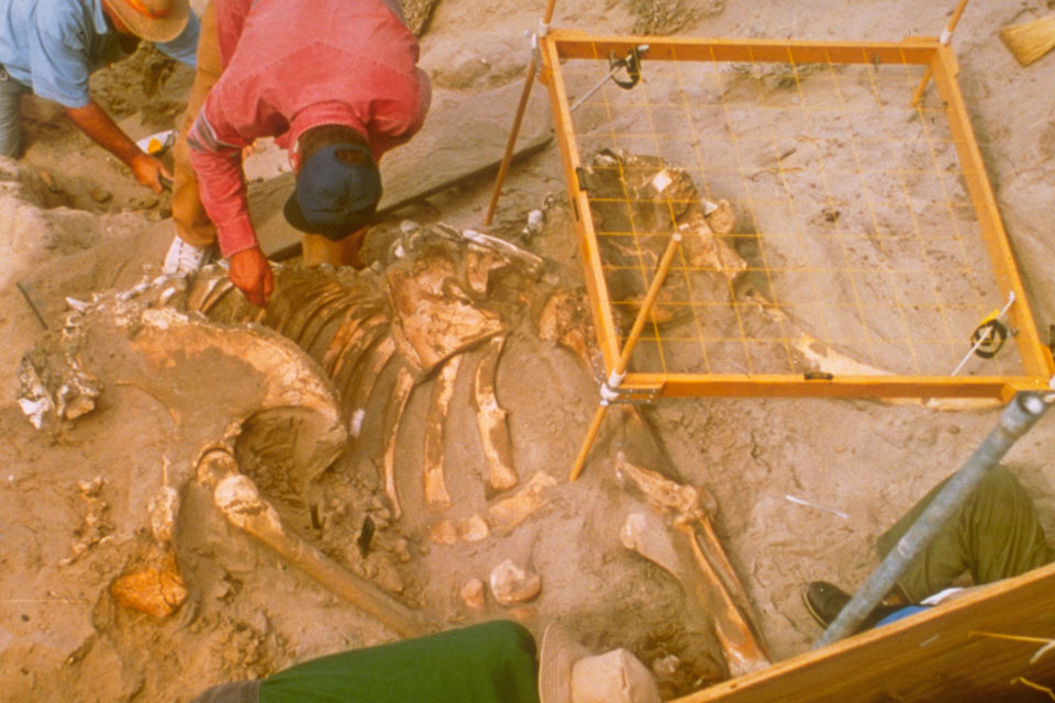
The Channel Islands are off the coast of California, stretching 160 miles from Santa Barbara to Huntington Beach. They appear to be giant rocks floating on the open ocean. These islands were never attached to the mainland and rose from the ocean floor millions of years ago. Plate tectonics, volcanic activity, fluctuating sea levels, and expanding polar ice caps have all contributed to the creation of these unique islands. The islands are rookeries for seabirds and sea mammals, including one of the major breeding colonies of California brown pelicans. Dinosaur bones that have been found on the islands include a species of pygmy mammoth.
The native gray island foxes flourish today on Santa Cruz Island, and they are known as effective beggars as well as pretty sneaky should you leave you lunch and snacks unattended.

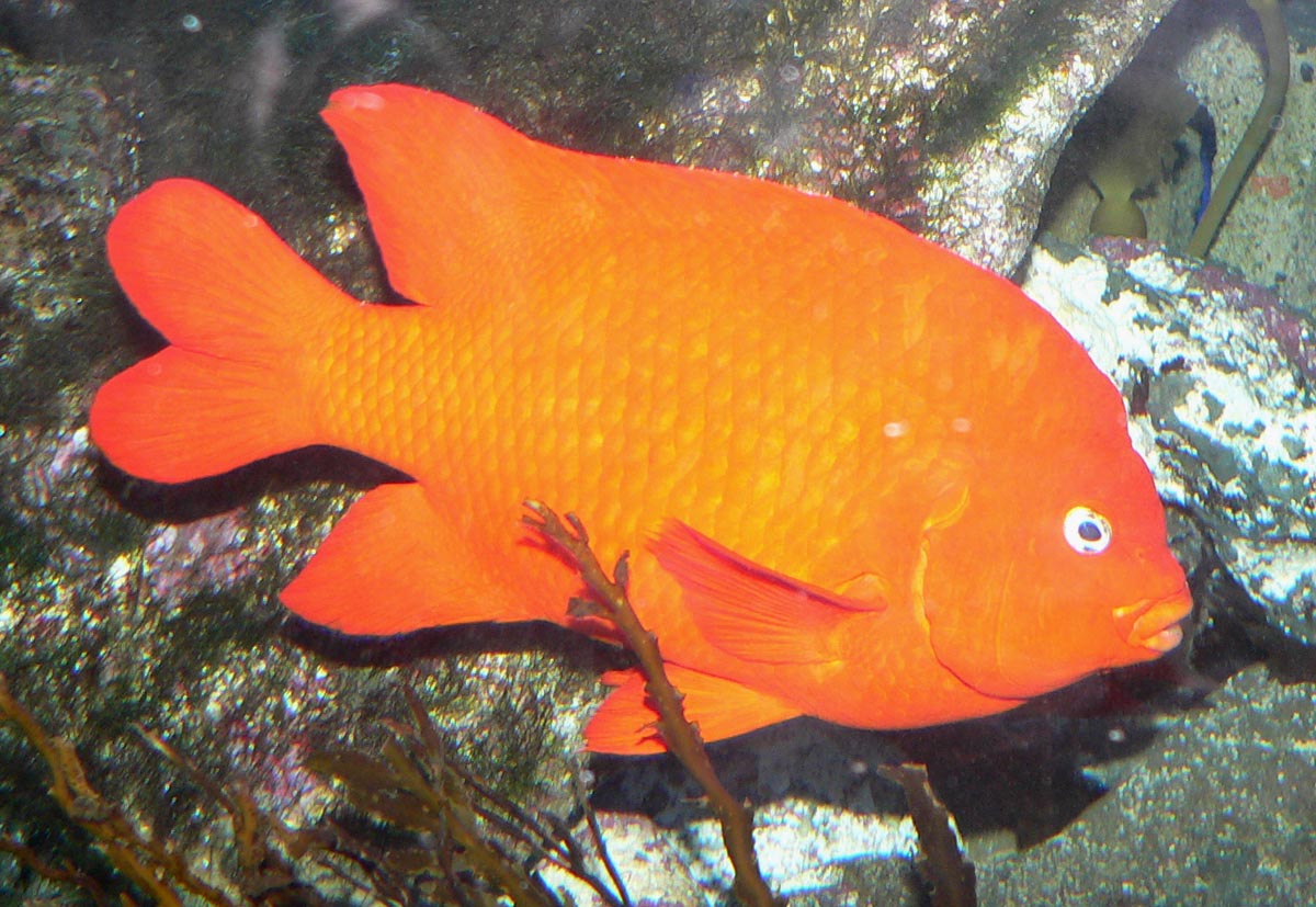
The wild and natural state of the islands has lead to a diversity of both plant and animal species that is rare; there are plants on the islands that are not found anywhere else in the world. The land as well as marine ecosystems support a rich diversity of life, including the State Marine Fish, the bright orange garibaldi.
The islands were home to a number of different groups of people who lived there over 13,000 years ago. Indigenous peoples included the Chumash Peoples who settled in the northern islands (San Miguel, Santa Rosa, Santa Cruz, and Anacapa),and the Gabrielino/Tongva Peoples who settled in the southern islands (San Nicolas, Santa Barbara, Santa Clara, and San Clemente). The two indigenous groups sustained their way of life by actively trading with each other, using purple olivella shells as currency.

Other explorers (Spanish, missionaries, and ranchers) found their way to the islands, and Captain George Vancouver named the islands in 1793. In those early years fur traders nearly hunted sea otters, seals and sea lions to extinction.
By 1822 most of the indigenous peoples had been moved (!) to the mainland to make way for fishing camps and ranching operations. In the early 1900s the US Military established encampments on the islands as Pacific Ocean lookouts, and targeted parts of the land for Army Air Corps bombing practice. The devastation from all of this non-native human activity and the introduction of alien plants and animals nearly collapsed the fragile ecosystem.
It wasn’t until Anacapa and Santa Barbara Islands were designated as the Channel Islands National Monument in 1938 that protection for the ecosystem was assured and recovery could begin. And in 1980, Congress designated San Miguel, Santa Rosa, Santa Cruz, Anacapa, and Santa Barbara and the submerged lands and waters within one nautical mile of each island as Channel Islands National Park. Six nautical miles from each of the islands have been designated a National Marine sanctuary. The Protected Marine and Conservation Areas preserve these unique and primitive islands for future generations. It has taken decades to reestablish the natural diversity of plants, birds, animals and sea life visitors experience today.
Channel Islands National Park is one of the 4 National Parks accessible only by boat or seaplane. Anacapa Island is closest to the California coast, a mere (?) 11 nautical miles west of Oxnard Harbor; at 65 nautical miles from the mainland, San Miguel Island is the furthest west of the Channel Islands.

“The Channel Islands lie in a region between the mainland coast and the deep ocean known as the Continental Shelf.” Ocean scientists have determined that the ocean floor consists of canyons, sea mounts, banks or underwater plateaus, escarpments and deep basins. Did you know that Santa Cruz Basin is deeper than Arizona’s Grand Canyon? Now you do! Imagine the diversity of sea life that inhabits this underwater topography.
We packed the Jeep and traveled the 495 miles to Oxnard, California. It would take us seven hours to make the journey across Arizona in the midst of monsoon season and deadly high temperatures. We watched the temperature gauge in the Jeep climb as we drove through Kingman and Bullhead City, topping out at 108 or so by the time we got to Needles and the Mojave Desert. We were grateful for our air-conditioned car and reminded ourselves how smart our decision had been to spend the Summer in Williams!

We arrived in Oxnard about 4pm, and checked into the Hampton Inn near the beach. We had a lovely second floor balcony room overlooking hundreds of sailboats in the harbor, and we were welcomed by the cool ocean breezes and the sounds of barking seals and noisy seagulls. It was time to take a walk to stretch our weary legs; the helpful desk staff gave us directions to the beach and even made a recommendation for dinner.


The Pacific Ocean – what a welcome sight! Crashing waves under blue skies, soft sand and warm salty ocean breezes.


We always carry a face mask with us but the beach was fairly empty; most everyone was headed home or they were strolling along the shoreline without a care as the gentle waves lapped at their feet. What a great place to unwind.
We wanted to be back to the hotel before sunset so we headed to the “fish place” for some fresh halibut and clam strips. The family-owned restaurant offered take out only but the menu options included fried and grilled fish and seafood, sushi, and featured dishes made with fresh red sheepshead. The food was as delicious as promised.
As we got ourselves prepared for the first of our two excursions to the Channel Islands the next morning, we were treated to a glorious sunset that seemed to last and last, gradually changing from muted yellows and oranges to the deepest reds. A perfect ending to our first evening in sunny California.


We arrived early at the offices of Island Packers in Ventura Harbor so that we could pick up our tickets and prepare to board the ferry to Santa Cruz Island. We enjoyed the antics and the noise of the young harbor seals as they playfully chased each other up and down the docks as older larger seals were sunning themselves on unoccupied docks where they were generally enjoying a brief rest from all the youthful activity.


We had dressed in layers as recommended by the ferry company in anticipation of a chilly 26-mile ride to Santa Cruz Island, and because of the potential for rapidly changing weather conditions while at sea. We wore our swimsuits under our clothing and jackets. For our day on Santa Cruz Island we had scheduled a kayaking trip that was advertised to last a couple of hours; we figured we’d have lunch afterwards, and then have a chance to take an exploratory hike of the island.
There are no supplies on any of the Channel Islands (water, food, other necessities) so we packed accordingly. Several passengers boarded with back packs and plastic bins of camping gear. We had read that there were primitive campgrounds for hearty souls who wanted the experience of camping on a remote island.
Face masks were required throughout the ferry ride. At 20 knots per hour the ride was fairly windy, but we ventured out onto the bow of the boat when a pod of dolphins was spotted by the ferry’s captain. For landlubbers like us, it was a thrill to see these magnificent creatures bobbing along the surface of the water so close to us.


It was also our first glimpse of the islands on the distant horizon.


We docked about 60 minutes later, and the crew assisted the campers then the rest of us as we disembarked.

We were greeted by the masked National Park staff who directed us to join the other masked kayakers. The tall cliffs rising out of the ocean and the sandy beaches devoid of people gave us an eerie feeling like we were perhaps on one of those reality TV shows that requires survival skills in order to stay alive…


Not to worry. The National Park staff reminded us that we were to wear our masks while on shore, and that we were responsible for our own safety while we were on the Island. Any trash we created we had to take back with us because there is no trash service on any of the Islands. We were also warned about poison oak and ticks, to avoid all contact with deer mice (hantavirus) and other wild animals, and please don’t feed the island fox. Oh, and don’t take anything (rocks, shells, plants, etc.) from the island. As we have been repeatedly reminded along the way in the National Parks we have visited: take only memories – leave only footprints.
We made our way to the staging area for our kayaking adventure with Captain John. There were four, two-seater kayaks in our group. Some members of our group had previously kayaked; one young woman had never been in a kayak before but she was eager to try it. We were offered wet suits (optional), a polyester jacket (optional), life vests and helmets (not optional), all of which we decided would be a warmer option than the clothing we had on. Oh, and “croc sandals” (plastic shoes) in a dizzying array of colors and sizes just in case one didn’t own or bring water shoes. There were changing tents available but some people just disrobed and squeezed into their gear.


Like little ducklings, off we waddled to find our kayaks. Captain John has been a kayak leader for seven years and he has visited Santa Cruz Island often over the past 40 years. Santa Cruz is the largest of the five islands in the National Park; it is 61,972 acres, is 22 miles long and from two to six miles wide. He told us that on one of his adventures it took him three days to kayak around the whole island; he is happiest when he is on the ocean in a kayak. He showed us the best way to get in and out of a kayak; that the person in the rear of the kayak – usually the heavier of the two people – is in charge of steering the kayak (“they’re not necessarily the boss”); and what to do if you should fall out of your kayak or capsize entirely. He engendered trust in us and we were excited to begin. We pushed our kayaks out into the ocean and waded knee deep into the August-warm (?) water, and we each managed to successfully get into our kayaks on our first try. With further instructions about the use of the paddles we had been given, off we set to explore the coastline.
What was billed as a two-hour trip turned into a three-and-a-half hour trip. We were encouraged to stay close to the shore as we paddled into the westerly winds. We were visited by seals who bobbed up out of the water to check us out; seagulls and pelicans accompanied us as they enjoyed the winds aloft. We could see lots and lots of colorful garibaldi fish in the clear green waters, and the rocky coastline gave way to dark caves, blowholes, an amazing arch and other small beaches. There are giant kelp forests all around the islands that help to feed the sea life, including blue whales. We waved to people on sailboats who had set anchor in hopes of a quiet break from their workaday world. Any fears or trepidation we may have had about being out on the open ocean in a kayak were soon quelled.


Although we stayed about a quarter mile off shore in order to head straight back to the docking beach, kayaking back seemed to take no time at all – maybe we finally figured out how to make the thing glide through the water! With the wind at our back and some favorable tides we arrived and disembarked safely. Our sea legs recovered quickly as we were helped to return our kayaks to the shore. Tired and hungry, we retrieved our clothing, backpack, phones and camera, changed our clothes and found a sunny spot for lunch. It was after 3:00 and our ferry ride back to the mainland was scheduled for 4:00. We didn’t feel we had enough time for a hike but vowed that we would return to Santa Cruz Island another day.


The trip back to the mainland was uneventful, and we were content to relax and enjoy the ride.


Re-entering the harbor after our day at sea we were greeted by seals and sea lions just hanging out – must be Happy Hour!

Tired after our incredible adventure, we ordered in so-so Chinese food and called it a night.
Bright and early the next morning, we checked out of our hotel and headed to Island Packers in Oxnard for the trip to Anacapa Island, the smallest of the Channel Islands. Barbara’s sister, Meg, joined us for this excursion. Even though Meg has made California her home for the past 50+ years, she had never been to the Channel Islands. With face masks secured, the ride to Anacapa was fairly quick; it’s only 11 nautical miles southwest of the mainland, and we were happy to be escorted by pods of porpoises along the way.


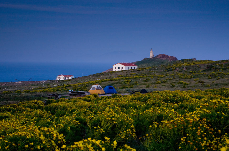
Anacapa Island is comprised of three small islets: East, Middle and West. The ferry docks on East Anacapa; there is a small beach on the West Islet called Frenchy’s Cove that can only be reached by boat. The Middle and West Islets are protected habitats for brown pelicans and sea lions.


Anacapa is considered to be a “cliff island” so there is no access to the sea except at the Landing Cove.


As a cliff island, getting to the mainland requires a climb up 166 metal steps…

At the top we were greeted by a National Park Ranger. We were offered a hiking map, told to stay on the designated paths and to be aware of poison oak, cholla cactus, ticks and scorpions. The Ranger cautioned us to be careful at the overlooks and cliff edges, and to be respectful of the wildlife we encountered. Interpretative guides are not available this season due to the threat of covid-19 exposure from groups of people, but the island trail proved to be very straightforward; a set of figure-eight paths meandering up, down, and around the coastline with spectacular views.


One of the first things you notice on Anacapa Island is the thousands of Western Gulls. They’re a noisy smelly lot and they’re everywhere. Some were large white and black creatures with a red mark on their beaks; others were smaller and brown. We presumed the brown ones were juveniles or maybe the females. Like penguins who all look alike to us, we had a hard time imagining how the juvenile birds knew who their parents were as they begged to be fed.


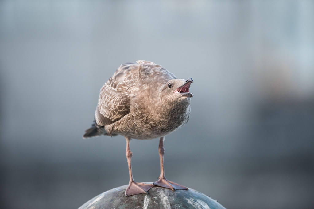


The Western Gulls didn’t seem particularly bothered by visitors as we trekked our way up the hill to the lighthouse.

Walking down from the lighthouse we were able to have a magnificent view of the entire eastern islet of Anacapa Island.


We couldn’t imagine what it would be like to spend the night on the top of an island in the ocean, open to all of the elements in an ever-changing and unpredictable weather pattern, and, of course, to the constant squawking of the gulls. We could also imagine the magnificence of the night sky we would see.
As we strolled the easy 4-miles around Anacapa Island we were awestruck with the views from overlooks…


…And we were delighted to observe sealions enjoying their swim


Throughout our journey we were able to admire all the unusual plants that we believe are found only on Anacapa Island and nowhere else in the world.


The other remarkable creature that calls this place home is the California Brown Pelican. The West Islet is a Marine Conservation Area and Rookery for fledgling pelicans, and, except for the beach at Frenchy’s Cove people are prohibited. Watching these majestic birds in groups of five or more, masterfully floating on the winds aloft, effortlessly gliding through the cloudless skies was mesmerizing. These pelicans are one of Brian’s favorite creatures; he took lots and lots of photos.


The ferry back to the mainland was enhanced by a side trip to the backside of the arch and to a part of the island frequented by sea lions. Giants of the sea, leisurely basking in the afternoon sun. What a life!


We had the best views from the top of the ferry as we motored home; it gave us a chance to really see the California coastline and what appeared at first glance to be a “mushroom cloud” that grew and grew the closer we got to shore. We later learned that it was a forest fire in the San Diego mountains. California has not had much rain this Summer.

And as we motored back into our slip in Oxnard Harbor we were welcomed by a sealion swimming by and the cacophony chorus greeting of seals on the dock.


Our experiences on Santa Cruz and Anacapa islands will be remembered and talked about for a long time. We have come to further appreciate our National Park system, and all of the individuals who have chosen a life of solitude and isolation for the protection and preservation of these incredible islands. We were humbled by the experience and have vowed to return in the not-too-distant future.
Barbara and Brian

What an amazing adventure you guys had!
LikeLike
I am so jealous of your ongoing adventures. These islands look especially fascinating. (Although, I’ll be honest, I’d still be concerned about the warnings about various wildlife!) And what a smug fox face on that adorable tiny fox! Can’t wait to see what happens next!
LikeLike
Don’t be jealous…perhaps it’s time for you and the family to start thinking about what trips you’d like to experience? You never know what you’ll do until you start to dream and make a sorta plan. I know we keep saying we’ll like to go back here and there, but these islands are so different (and with family nearby) going back the the Channel Islands is tops in a return engagement! Next “bigger” trip will be to Death Valley later in September. Should be cool!
LikeLike