
April – May, 2019
It’s supposed to be 90 minutes from Kanab to Bryce Canyon National Park, but the transit time really depends on wildlife, the vehicles ahead of you, the weather, and your own desire to see another of Mother Nature’s wonders. Deer slow you down. Due to the Canyon’s elevation and negotiating the steepness of the hills, Over-the-Road Vehicles, RV’s or a family out for a Sunday drive all slow you down. Freak snow storms slow you down. Traveling early on a nice sunny day, the trip barely takes an hour.
From Kanab we headed north to head east to reach Bryce Canyon NP. The road into the Park passes through Red Canyon State Park and Bryce Canyon City. Red Canyon State Park gave us a splendid introduction to the beauty of weathered iron rich sandstone formations.


It’s all about the Hoodoo’s! Canyons are usually formed by a process of deposition (receding seas leave a deposit of sediments, soils and rocks which is added to a land mass); uplift (the earth pushes up; i.e. shift of tectonic plates and/or underground volcanic activity); drainage (patterns of river flow from headwaters to mouth), and erosion (the process by which soil and rock particles are worn away by gravity, wind, water or ice). Or as one park ranger explained, “DUDE, it’s complicated.” Hard to really say which is the most powerful of these factors; just that some form of water “on the move” is involved for millions of years.
The uniqueness of Bryce Canyon is that it wasn’t the DUDE process, but the process of frost wedging that created the canyons and the things we call hoodoos. Hoodoos are statuesque spires of sandstone that started life as a wall of sandstone. Through erosion, narrow walls separate from the larger wall and are called fins. Water trickles into cracks in the fins. Freezing enlarges the cracks (water expands when freezing) creating holes or windows in the fins, and thawing ensures that water remains in the cracks. Annually Bryce Canyon experiences 200+ nights below freezing, ensuring that the freezing/thawing (frost wedging) process remains on-going. As the windows enlarge their tops eventually collapse leaving a sandstone column. Rain and wind finish the process and a hoodoo is born. As we studied the hoodoos in Bryce Amphitheater, we realized that part of their beauty comes from their strange shapes and patterns, and that new hoodoos are formed as older ones dissolve into lumps of clay – an ever-changing panorama.


A brief word about Bryce Canyon City. In 1916, Reuben C. (Ruby) Syrett brought his family to Southern Utah, establishing a ranch near the present entry into Bryce Canyon NP. A few weeks after his arrival, Mormon homesteader and nearby rancher Ebenezer Bryce told Ruby of the canyon. It is said that Ruby and his family made a Sunday visit to the canyon rim, and they were so impressed by what they saw that they not only took full advantage to tell people of the canyon’s beauties, but they also became hosts to its visitors. By 1919 they had obtained permission from the state to build a lodge…hence Ruby’s Inn, which in 2007 was incorporated as Bryce Canyon City. The town encompasses 3.5 square miles and has a population of 223. Everything, and we do mean everything in town is owned by the Syrett family.

There are so few parking spots within Bryce Canyon NP that by 8am, when the Park officially opens, the visitor center and trailhead lots are full; avid hikers are already on the trails. As an alternative we parked for free in Bryce Canyon City – just outside of the Park. The Park Service maintains the spacious parking lot. Starting at the shuttle center, buses pick-up and drop-off visitors at each of the Park’s 14 stops. The Park Service’s shuttle system is impressive; drivers are pleasant and welcoming, each affording a wealth of knowledge about the Park, and they are well able to describe the attractions and hiking trails associated with each of the shuttle stops. Perfect…
We made a reservation for the free (!) Rainbow Point Tour; a multi-stop, narrated 3.5-hour, 40-mile round trip from the shuttle center to Rainbow Point, the highest and farthest point in the Park, and we figured that the tour would be a great introduction to Bryce Canyon NP. The Rainbow Point Tour begins at Bryce Point, where the Park shuttle begins its return journey to the shuttle center, and includes 7 different opportunities to walk to the rim of the canyon, look down onto the hoodoo formations and look out on the forever horizon. We made friends with our tour guide and shuttle driver, George, and found out that he has lived, camped and worked in this part of Utah his entire life; he taught his children to love and respect the beauty of the land, and once retired, he volunteered with the Park Service as a tour guide. He has a full repertoire of jokes, clichés, and quips at the ready to entertain, but it is his incredible level of knowledge about the Park’s geology, its vistas and views that made for a terrific tour.


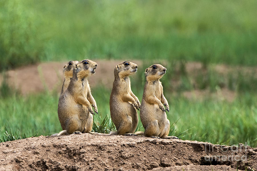
The famous Bryce Canyon National Park prairie dogs always arrange a welcome for visitors to Bryce Canyon NP.
After our tour it was time for a quick lunch and then on to “hike the rim.” The Rim Trail in its entirety is 11 miles – far too much for us to do in a day, if at all. But there is a 3-mile section of the trail that begins at the Bryce Point (shuttle stop), passes by Inspiration Point and Sunset Point and ends at Sunrise Point (shuttle stop). Our first glimpse of Bryce Amphitheater literally stopped us in our tracks, and brought Barbara to tears…it is so incredibly beautiful.


The cool part about this section of the Rim Trail is that it permitted us the opportunity to see the Bryce Amphitheater from a number of different angles. We found ourselves trying to complete gestalts, wondering what shape those columns of chocolate, vermillion, pink, gray and white sandstone had taken on. Are those terra cotta warriors? Is that an ancient walled city? Or does each of the hoodoos hold the spirit of the ancestors as the indigenous Paiute’s believe? Only each individual’s mind’s eye defines what it sees.


We felt that the Rainbow Point Tour and our rim hike was not enough to properly experience Bryce Canyon NP. Brian wanted to hike “under the rim” and amongst the sandstone spires…amongst the hoodoos. We wanted to hike the Fairyland Loop, but the trailhead is between the shuttle center and the formal entrance to Bryce Canyon NP and therefore not a shuttle stop. The trailhead is about 2-3 miles from the road and 4 miles from the visitors center; the first shuttle stop inside the park. We were early, but the parking lot was full.
Second choice? The Queens Garden trail is rated as an easy 1.8 mile hike…liar, liar pants on fire! The description failed to note that the Queens Garden trail also drops 357 feet into the canyon at a consistent 2-4 degree angle to slope down and, silly human, back up. Let’s see, what’s Brian always saying? It’s stress on the knees going down, and stress on the cardiovascular system going up. But taking an easy pace and with plenty of rest along the way down and up we joyfully completed the hike in 90 minutes.


We had hoped to pair the Queens Garden with the Navajo Loop, but it was closed due to the condition of the trail. Next choice? The Tower Bridge trail is rated as a strenuous 3-mile hike dropping 802 feet into the canyon, and as we discovered, at an even greater angled slope than the Queens Garden trail. We completed about 1/2 to 3/4 miles of the trail before enough was enough. We really were exhausted…oh, did we forget to mention that the rim of Bryce Canyon varies from 8,000 to 9,000 feet. An excuse for not completing the second hike? Perhaps, perhaps.

The horizon affords its own beauty as well – we could see the buttes of the Paria and Kaibab Plateaus standing tall in defiance of the surrounding geology. Our Rainbow Point tour guide pointed out the rise in topography that, 156 miles south, seen here on the horizon was the North Rim of the Grand Canyon. Yes, it is that clear!


We loved our hike amongst the hoodoos. We loved the ever-changing picture and color of Bryce Amphitheater from the rim. We loved imagining Paiute encampments and the stories passed on from generation to generation around their campfires. The vistas are breathtaking…
Barbara and Brian

I feel like “Wow” is probably getting to be a boring response, but I’m not sure if there’s a better way to respond!
LikeLike
We’ll keep taking those wows…I’m really happy you enjoy the blogs as much as you do!
LikeLike
Some of the most amazing photos yet!
LikeLike
Thanks. Looks like you guys had a blast in Ireland.
LikeLike