
July, 2019
Pop Quiz, Hot Shot (name that movie for a bonus point).
Name the 3 National Parks, 2 National Monuments, 2 cities you just must visit when in the area; South Dakota’s first State Park, the world’s largest mountain carving, the most advertised and famous apothecary in the U.S., and the city that has memorialized every US President with statues on their downtown street corners that are all in or near the western Dakotas? Hint – 1 of the National Monuments is not in the Dakotas.
We’re guessing that there’s really no mystery knowing where our journey started so long ago has taken us. We’re in the Black Hills, a small mountain range rising from the Great Plains of North America that extends from western South Dakota into Wyoming. The name “Black Hills” is a translation of the Lakota phrase “Pahá Sápa,” and is thought to have been so named because of their dark appearance from a distance.
Our campground was 5 miles or so east of downtown Rapid City, South Dakota (population a bit more than 74,000 souls), and when we pulled in we were given the choice of a shady back-in site or a pull through in an open field with no protection from the July sun. Temperatures were predicted to be in the high 80s and lower 90s, and as road warriors for the past 14 months backing in is an easy task – there was no hesitation in our decision.

In doing our research, we read that every evening at sundown there is a lighting ceremony at the Mount Rushmore National Memorial that honors the enshrined 4 US Presidents. Could this be a hidden gem?
As much as we love to hike, and there are trails in the park, we thought it’d be ok this time to just relax and enjoy the ceremony. If you get there early enough (and we didn’t, and the lines were way, way too long), you can get yourself an ice cream made from Thomas Jefferson’s chef’s recipe.

After parking our car and walking up a short flight of steps to enter the Memorial we were greeted by our first view of Mount Rushmore. We were so focused on the carvings, we barely noticed walking through the Avenue of Flags. There are 56 flags representing the 50 states, one district, three territories and two commonwealths of the USA (more bonus points if you can name the territories and commonwealths; minus one if you ask what district?).
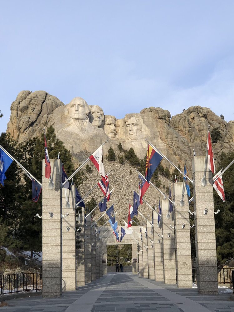


The ceremony begins after the sun has set, and many people arrive a good hour or so before sunset to be able to pick a prime spot from which to observe the monument being lit (and to get an ice cream – sic). The well-thought-out ceremony is pre-recorded and performed by a Park Ranger who begins with a brief introduction about the Memorial followed by a reading of inspiring thoughts on liberty written by each of the 4 enshrined Presidents. The ceremony then pauses to honor veterans and active-duty servicemen and women in attendance, and it concludes with the playing of our National Anthem. At the end of the Star Spangled Banner the monument is bathed in light. Listening to what these 4 men had to say about liberty and, in their opinion, what it means to live in the United States we both realized that it’s been a long time since we felt so proud to be Americans.

Kea went to Carleton College in Northfield, Minnesota (yeah – of the Jesse James Gang fame!), and after graduation some 28 years ago, Badlands National Park was on the agenda for the trip back to Colorado Springs. Barbara was along for that trip, and she wouldn’t say much about the Park – she wanted Brian to form his own first-timer impression.

Badlands National Park has 5 entrances. An entrance on the Oglala Lakota Pine Ridge Reservation which is south and west of the Interior Entrance (Ben Reifel Visitors Center) – not a touristy location to see the badlands, but great if you want to experience Oglala Lakota culture.
The Interior, Northeast and Pinnacles Entrances connect to the paved 28-mile Park Loop Road which winds through the Park – a number of pull-outs along the way afford a chance to view the topography, uniqueness and beauty of the Park.
Travel a gravel road for 25 miles or so to the Park’s entrance off of Sage Creek Rim Road. This entrance brings the visitor through the Badlands Wilderness and provides views along the Park’s Northern Rim, past prairie dog towns and herds of mountain goats before connecting to the Park Loop Road. We just can’t help ourselves – really – gravel roads must just be to our liking as we chose the Sage Creek Rim Road as our way into the Park.


As we entered the Park we were greeted by a prairie dog town, and we were very lucky on this intensely hot day that the prairie dogs were scampering about from one burrow entrance to another, visiting with each other, and just hanging out outside their burrows. Someone must have paid them to pose for pictures!
Prairie dogs are gregarious herbivorous ground squirrels (related to marmots!) found on the great American prairie, that live in a community of interconnected burrows. Their warning call sounds like a domestic dog’s bark – well, you can figure out why these ground squirrels are called prairie dogs…
Brian could have sat and watched those little rascals for hours.


As we traveled along the North Rim we could just begin to make out what was to come…from the vistas it was a pretty obvious conclusion as to why this is called The Badlands.


A few miles further and we saw vehicles parked on both sides of the roadway. In Yellowstone NP this is a sure giveaway of a wildlife sighting. Of course, we had to stop…


The Park Loop Road can be traveled in an hour to an hour and a half, and visitors have plenty of time to stop at each of the dozen pull-outs for sight seeing, even at the busiest of times in the Park.


Our visit took a bit longer. We added a short hike to the top of the Yellow Mounds…


…and took a 2-3 mile hike in Burns Basin along the Castle Trail with dazzling views of the sandstone formations.


Badlands National Park is a unique place on earth for 2 reasons: the Park is half geologic formations and half mixed-grass prairie ecosystem, and the Park’s geologic deposits contain one of the world’s richest fossil beds. Preserved in the layers of exposed rock and ancient soils are examples of brontotheres ( ancestors of rhinoceroses and horses); oreodonts (hogs, boars); camels, entelodonts (pigs), rabbits, rodents, and carnivores.


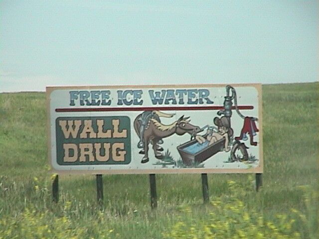
From the Ben Reifel Visitors Center it is only 30 miles to Wall, South Dakota. The story of Wall Drug is the story of American ingenuity and capitalism. In 1931, Ted and Dorothy Hustead moved from Nebraska to Wall, South Dakota in order to establish Ted’s pharmacy practice. Almost to the point of failure, Dorothy came up with the brilliant idea of giving anyone who stopped a free glass of ice water. Ted posted oh so many advertising signs along the highway drawing visitors in for that cold drink. Move forward almost 90 years and Wall Drug has become a roadside attraction, a family amusement destination, play ground and water pad, shopping and souvenir mecca, a place for a decent meal and fabulous ice cream, and museum. Don’t worry, you can still get that free glass of ice water! Had to stop…


The discovery of Wind Cave National Park occurred in 1881, when the Bingham brothers heard a loud whistling noise coming out of the ground. On further investigation they discovered the only natural entrance to what is now known as Wind Cave. More than 130 miles of passages have been explored and mapped, the overall distance making it one of the world’s longest caves.
The uniqueness of Wind Cave is the speleothems that exist within the cave. Speleothems are structures formed by the deposition of minerals from water, and they are classified by their shape: popcorn, frostwork, dogtooth spar crystals, and flowstone. However, Wind Cave’s most famous formation is boxwork; a speleogen (formed by erosion not deposition) in a honeycomb pattern. Wind Cave contains almost all of the boxwork found in the world.

We called ahead to schedule our visit Wind Cave National Park only to find out that the elevator (and only way to descend into the cave) was under repair, and the repairs were not expected to be completed much before Fall. We were pretty disappointed that we couldn’t descend into the cave, but we were determined to visit this National Park. We asked about Ranger tours or talks, and we were able to sign on for a Ranger hike to the area’s buffalo jump and talk about what life was like when the Sanson family lived here in the 1880s. The Sansons were early settlers, and in spite of the extreme conditions found in the Black Hills, they were able to run a successful cattle ranch. They donated their ranch to the Park as a way to teach others about their life.


The Ranger who lead our hike gave us an appreciation for the austere life faced by settlers on this prairie.

Custer State Park is a short ride north of Wind Cave NP, is named after, you guessed it, George Armstrong Custer, and it is South Dakota’s first and largest state park. Its 71,000 acres are filled with hiking trails, play areas for youth and families, visitor and educational centers, pavilions for events such as the wedding taking place the day we were there; a truly beautiful ride along any of the roads: Iron Mountain Road, Needles Highway, Wildlife Loop Road, or Peter Norbeck Scenic Byway. There are scheduled activities day and night – truly one of the nicest state parks we’ve seen to date.
Did we mention that Custer State Park is also a wildlife refuge? As we entered the Park from the south, Brian heard what he thought was a motorcycle club riding the Iron Mountain Road. Nope – the sounds were being made by a heard of bison! We’ve all heard a bison’s snort, but this was nothing like that. We could hear them before we saw them – a deep guttural rumbling sound that filled “the whole space” in the valley. Barbara recorded the sounds, and she will play it for you if you ask.


We decided to hike the Lovers Leap Trail, a difficult 4.2 mile loop, 695-foot ascent hike that features beautiful wild flowers and provides scenic views of the surrounding Black Hills from the top of the hill. The trail also features at least 8-9 crossings of the French Broad River.


We were a little more than 2 miles into the hike when Brian jumped backward and screamed like a little girl…now Barbara was very kind and swears that he yelled snake. And wouldn’t you know it? After all the miles hoofing it in so many different kinds of environments and weather conditions we finally encountered a rattlesnake. The rattle was barely off of our path and it could be easily seen (and heard!); the body of the snake was visible in the tall grass, and it was wrapped over a fallen tree trunk. At first we couldn’t see the viper’s head. We leaned forward and the rattle rattled. We moved laterally and the rattle rattled. We gave the tree trunk a kick and the rattle rattled. When we moved backward or stood still there was no rattle. Brian could finally see the viper’s head on top of the tree trunk and he (she?) was starring us down. Barbara suggested running past the snake. Brian reminded her that the rule with bears is that the slowest person is lunch, but with snakes they simply strike out at whatever moves within their range. Discretion being the better part of stupidity we turned around…after all, it’s the snake’s home, not ours. (Elyssa…Warning! Warning!—pass on the next 2 pictures)


Good start…enjoying the blog, the story and pictures? Well, hold on for the next installment of our time in the Dakotas…Exceptional!
Barbara and Brian
