
August – September, 2019
Williams, Arizona is a small town (population 3,159) with a big mission. It’s 60 miles from the south rim of the Grand Canyon, and a large number of visitors to the National Park depend on the town for room, board, entertainment…and a ride to the Park.

The Grand Canyon Railway has operated continuously since 1901. Train aficionados, celebrities, groups, singles, couples and families have all ridden the rails as their way to arrive at the Park. The journey begins at the restored Atchison, Topeka and Santa Fe rail terminal in Williams, and it ends at the Grand Canyon Depot, a short walk to the South Rim and the El Tovar Hotel.


Railside RV Campground is next to the side rail (think train parking lot) of the Grand Canyon Railroad, is owned by one of the friendliest families we’ve encountered in our travels, and offers nice amenities like a daily free breakfast (waffles!), and on Labor Day it hosted a bbq dinner for campers.


The Mother Road ran right through Williams…


…and we were delighted to find not just a bicycle-friendly quaint small town, cool stores, restaurants, bars and a few murals, but a full service grocery store and a Dairy Queen!


It is indeed a short distance from Williams to the Grand Canyon, but it is also not too far to many other wonderful Arizona attractions and National Monuments…dig…
You may prefer “Desperado,” “Hotel California,” “Lyin’ Eyes,” “Peaceful Easy Feeling,” “Tequila Sunrise,” “Heartache Tonight,” “Best of My Love,” “Take It To The Limit,” or “Life In The Fast Lane,” but when Jackson Browne and Glenn Fry wrote “Taking It Easy” for The Eagles, Barbara and I are pretty sure they didn’t mean to make Winslow, Arizona famous.
Winslow is 75 miles east of Williams, and like so many of the towns along The Mother Road, the city began to fail when the completion of Interstate 40 diverted traffic from going through downtown.
Standin’ On The Corner Park was dedicated three decades after The Eagles released their recording of “Take It Easy.”


100,000 visitors pay homage to the song by visiting the Park annually; tourism providing some relief from business lost when the Interstate was completed.
The Park is not the only reason to visit Winslow. Designed by architect Mary Elizabeth Jane Colter (female architect in 1920!) and a part of the Harvey Hotel chain (yup – of movie fame!), the Hotel La Posada has served the rich and famous including Hollywood stars, politicians and celebrities from all walks of life over the years. Where else could you stay in the Amelia Earhart suite, the Howard Hughes or Albert Einstein room, or other rooms named after the celebrities who stayed at the La Posada?
All along the path of the Santa Fe Railroad, Fred Harvey built and ran his Harvey Hotels with a single vision – to “civilize the west,” and his Harvey Girls made sure that the traveler was treated to only the finest food, accommodations and, most importantly, top-notch service.


The design of the La Posada is classically adobe with bright airy rooms, beautiful tile flooring, and museum quality artwork throughout (check out Tina Mion). One particular piece hanging in the ballroom was just bizarre enough to hold our attention for quite a while…

10 miles or so west of Winslow on Route 66 is what remains of Two Guns, Arizona. We stopped not for the fine ambiance (sic), but to find the Apache Death Cave.

The Apache Death Cave became a part of history in 1878 when a group of Apache raiders attacked a Navajo encampment killing all of the camp’s inhabitants except for three girls. The girls were taken prisoner by the raiders, and they were subsequently sexually abused and tortured before being put to death. Once Navajo leaders received word of the attack, they sent out men to find the Apache raiders and seek vengeance. Just when the raiders’ trail had become cold, the Navajo men encountered a hot spot of ground revealing a hidden cavern where a campfire was burning inside. Upon discovering the hideaway where the Apache had taken cover, the Navajo killed the watchmen at the entrance of the cave and started a fire, killing all of the Apache therein.


Within shouting distance of the Death Cave we found ancient ruins worth a visit. We couldn’t help wondering what it was like living out here before any of our modern conveniences?

But finding an abandoned doll convinced us to move along at a pretty rapid pace!

Meteor Crater is repudiated to be the world’s best preserved meteorite impact site on Earth. It has been estimated that approximately 50,000 years ago a meteorite slammed into the earth with the energy of more than 20 million tons of TNT creating a crater that is nearly one mile across, 2.4 miles in circumference and more than 550 feet deep.
A few other curiosities about the Crater…Mining operations looking for a fortune in iron failed to find a motherload and were soon abandoned…During the 1960s and 1970s, NASA astronauts trained in the Crater to prepare for the Apollo missions to the Moon…On August 8, 1964, a pair of commercial pilots in a Cessna 150 flew low over the crater, and after crossing the rim they could not maintain level flight. One of the pilots attempted to circle in the crater in order to climb over the rim, but during the attempted climb out, the aircraft stalled, crashed and caught fire. A small portion of the wreckage not removed from the crash site remains visible.


 Montezuma’s Castle National Monument is a 45-50 room, high-rise cliff dwelling built by the Sinagua People. A short walk from the visitors center permits a clear view of the dwelling; climbing up to and through is not permitted.


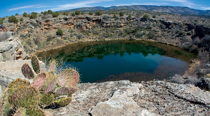
11 miles away is its sister monument – Montezuma’s Well. Water is essential for living in a desert environment, and this well meant life for the Sinagua People. The well is fed daily to the tune of 1,500,000 gallons of water from underground aquifers; however, the water is no longer potable. The water contains high levels of arsenic.

Barbara tells a story of crawling into a narrow cave with a couple of guys, one of whom was a boyfriend way back oh so many years ago. With 20/20 hindsight she reflected on how scary it was to be in the narrow passages of the cave, and how she survived the stupidity of adolescence. With that in mind we set out to find Lava River Cave. Lava River Cave is really a lava tube, and lava tubes are formed when lava on the surface cools and hardens as the lava under the surface continues flowing.
There are 3 things to remember when exploring the tube: it is totally and absolutely darker than you can imagine so bring a good flashlight (we forgot – thankfully another traveler left 2 powerful miners’ lamps we were able to use); bring water, and bring proper clothing for the constant 40 degrees Fahrentheit inside the cave.
Following our decent into total darkness we hiked a mile in a little more than 2 hours on “break your ankles” uneven rocky surfaces before turning around and hiking back out. Although on this day we were perhaps the oldest explorers in the tube, we weren’t alone down in the darkness – young couples, families, a group of teens, and small groups of young adults were all enjoying their time in the cave. Exhilarating!


Jerome is a small mountain community (population 455) with a days-gone-by reputation as a genuinely rough, tumble and lawless place, well-earning its nickname as the “Wickedest Town in America.” The discovery of copper (and a little gold) in the hills around what is now the city of Jerome put it on the map (population swelled to over 15,000 just after WWI), and much of the old-town feel remains. It’s fun to walk along Main Street and past plaques commemorating the boozing, brawling, and brotheling that was part of the town’s history.


Jerome is located on a steep hill between Prescott and Flagstaff – perhaps a little too steep, and in an implausible turn of events, Jerome’s original jailhouse went “on the run.” Following a slow slide down the mountain, the old jail can be found more than 200 feet from where it started. The concrete cell block was once part of a wood and tin building, but it pulled away from the rest of the structure after some underground blasting in 1938 shifted the ground beneath a substantial portion of the town. Although the jail was deemed unsafe for prisoners and evacuated, its gradual slide down the hill continued unchecked until it found its present resting place.


Down hill with about 35 miles of twisty switchback driving is the town of Prescott. Downtown reminded us of main street USA: a central square situated around the single government building and courthouse with greenspace all around. Locally owned stores, restaurants and bars are situated across the street, literally framing the square.
The day was perfect – the downtown square was busy with shoppers, families enjoying time together; singles enjoying the sunshine, a cup of coffee and a good book, and friends sitting on the benches enjoying the day and their conversation. Lovely!

In 1900 fire destroyed an entire city block of downtown Prescott, and with re-building came a large number of saloons that opened along the block (imagine that!). Whiskey Row remains a popular destination for locals and visitors to the town.


Sunset Crater Volcano National Monument preserves more than 3,000 acres within the Coconino National Forest. Upon entering the Monument we first experienced the Bonito Lava Flow, and it was amazingly similar to what we experienced west of Idaho Falls when exploring Craters of the Moon National Monument. We once again found ourselves viewing lava blocks and lava bombs, walking on and through a jagged landscape of cooled lava that had landed on and broken through the earth’s surface.


Sunset Crater Volcano is a 1000-foot-tall cinder cone that last erupted sometime around 1085 CE spewing liquid rock an estimated 850 feet into the sky (thank you National Park Service). As tiny bits of lava cooled off, they fell back to earth as small rocks called cinders or lapilli. These cinders piled up around the volcano’s vent, creating a cone-shaped pile we know today as Sunset Crater Volcano.

As we exited our car and began to admire the Volcano a rather tall thin young man engaged us in conversation. Turns out Phillip is a Slovak and a recent college graduate who gifted himself with a 40-day, “See America” vacation before returning home to begin his working career. He had begun his trip in NYC, and to conserve money, he was sleeping in his car. He was looking for advice about what to see between here and Los Angeles…he only had a few days left before his scheduled flight back home! We shared some time and stories together, told a few tall tales, and wished each other God’s speed upon parting. What a nice young man!
Wupatki National Monument is within 2-3 miles of Sunset Crater Volcano, and it was to be our next stop, but we were afraid of getting soaked which would cut our day short…

…But the rain held off and the clouds gave way to sunshine. Wupatki National Monument was established to preserve Citadel and Wupatki pueblos. But why these particular pueblos in this particular place? Anthropologists and archeologists believe that this site is a truly rare cultural crossroads – home to numerous groups of people over thousands of years who all managed to be at peace and thrive in what seems to be a very hostile environment.


Walnut Canyon National Monument preserves some of the Southwest’s earliest history. Used by Sinagua cave dwellers in the 12th and 13th century, this site has preserved their homes and we could get ourselves a close-up view inside. The canyon surrounding the ruins is up to 600 ft. deep and it was created by Walnut Creek, a small water source that eventually flows into the Colorado river in the Grand Canyon. Quite a distance uphill to haul water and downhill to plant/tend crops. The upper layer of this unique canyon is Kaibab limestone and contains ruins scattered around ancient rock.


While in the neighborhood we couldn’t help but take a trip to Sedona to see what mischief we could get into. This was our 2nd trip amongst the fantastic red buttes and hills of what some consider one of the most beautiful places in America. We were looking for an off-the-beaten path hike, and after asking around we followed a recommendation to hike the Doe Mountain Trail. Doe Mountain Trail is 5 miles or so southwest of the downtown area, and well away from the more popular hiking trails that are just east and a little north of town.


The Doe Mountain Trail is a little longer than 1 mile in length with a 1000-foot increase in elevation. We found ourselves scrambling over boulders, squeezing through a narrow passage or 2, and being challenged to find purchase for vertical ascents upward and descents on the way back down. Even with all of that in mind it is, all-in-all, a fairly moderate hike as long as the temperature and Mother Nature are reasonable. We always bring plenty of water with us on our hikes; however, it was well into the upper 80s when we started and in the low 100s when we returned to the trailhead drained and in need of some rest and extra re-hydration.
Once we reached the top we found ourselves on a butte on which a short walk brought us to beautiful vistas of the surrounding landscape.


Whew! Barbara and I just plan our days, record our impressions and take pictures not realizing the extent of what we saw until…well…we write the blog and get to enjoy once again the remembrances we share here.
There are so many National Monuments, State Parks, and local attractions (art fair anyone?) close by that we were very glad we had made Williams our home for the Summer. We feel that we had just scratched the surface of what this neck of the woods has to offer, and that it’d be great to return some day and spend a little more time exploring…
Next up? The Grand Canyon!!
Barbara and Brian

Sure enjoyed revisiting these places thru your pictures. Sure is a beautiful part of the country. Hugs
Sent from my iPhone
>
LikeLike
OK – Barbie face down in the sand is both creepy & delightful!
LikeLike
Right? The whole area around 2 Guns was pretty weird. Ready for the Holidays?
LikeLike
Roughly as ready as I can be. Sadly, my great-grandmother passed last week (though she lived a long and interesting life … in the end, Alzheimers took her away quickly). I wasn’t able to attend the funeral in Tennessee, as I was on caretaking duty in Bethlehem. I’m looking now for the little uplifting things to spark joy. As ever, I thoroughly enjoy your travel blog and all the pictures. Will you guys be hunkered down in your warm winter spot for the holiday season?
LikeLike