DESERT HITS AND A MISS

December, 2018 – January, 2019

DSC04266 (2)
Typical Adobe Home

Known as the White Dove of the Desert, the San Xavier del Bac Mission (pronounced hah-vee-air not zay-vee-air) is a remarkable and iconic example of Spanish Colonial architecture that can be found in many of the churches in the American Southwest; it is actually considered the oldest example of Spanish Colonial architecture in the U.S.   It is located about 10 miles south of Tucson on the Tohono O’odham Indian Reservation, and it is possible that many of the people currently living in the area are descendants of the O’odham who were converted to Catholicism by the Spanish Jesuit missionaries that settled the area over 300 years ago.

DSC04211 (2)

By 1692 Spanish Jesuit missionaries had brought Catholicism to the native Tohono O’odham peoples of this region.  St. Francis Xavier came to the region as a young priest and served the diocese his entire life.  He guided the building of the Mission structure, which was completed in 1797, and he is reputed to have converted more people than anyone else since Saint Paul.

DSC04213 (2)
Mission and Adjacent Buildings

On a bright cloudless sunny day, the blazing bright white Mission glows against the beautiful blue skies of Arizona, and you can see it long before you reach the parking lot. The building is being renovated.  Age and the effects of desert weather have had a negative effect on the exterior, and unfortunately, some earlier repair efforts in the 1980s using cement-based stucco caused water to be trapped inside the church and caused damage to its interior decorations.  The west tower has been repaired and the east tower is slowly being brought back to its previous glory.

DSC04205 (2)
The Façade Of The Mission.  Note The Difference Between The Renovated Left And The Right Sides Of The Structure

DSC04214 (2)

We arrived in time to join a group tour that was being directed to look at the ornately decorated entrance. The two massive doors are carved from mesquite wood.  On the far right and the far left of the façade over the doorway are a cat and a mouse.  Our guide said it is believed by some that when the cat catches the mouse, the world will come to an end.  (If you look closely, you can see two cats and two mice on the front of the building.)  We were led into the interior and seated in the last two rows on antique pews. We were asked to silence our phones and to speak softly as many of the people in the Mission were in prayer.  We listened quietly as the guide told us the history of the Mission, and we marveled at the elaborate details, exquisite paintings, and the incredible number of Catholic images that filled the walls and ceilings. There were also a number of statues of various Catholic saints on the exterior and interior.  A reclining statue in a glass case in the west transept was said to be St. Francis Xavier.  Our guide suggested believers say a prayer then lift the head of St. Xavier to be sure that the prayer is heard.

DSC04210 (2)
Chapel Ceiling
DSC04207 (2)
Looking At The Altar
DSC04209 (2)
View From The Altar To The Choir Loft

Seems kind of trite to say, but don’t miss purchasing some fry bread from the vendors who set up tents near the parking lot.

Agua Caliente Park was so named because at some point in the history of the park there was an active hot springs – it no longer exists. The ride to the park was beautiful: scenic surroundings and a roadrunner crossed the road right in front of us! How cool is that? As we approached the entrance to the park, runners and bikers were enjoying this fabulous winter’s day: 75 degrees and sunny making it an ideal day for exploring this new park.  We were delighted to see that the parking lot was nearly full. We had brought our bikes hoping that we could enjoy the park on two wheels.  However, we were greeted with a large sign that was filled with all the things visitors could NOT do, and biking was included on this long list.  We don’t know the history of the park and perhaps it has had more than its share of problems and hence the need for all the rules.  Nonetheless, we quickly nicknamed Agua Caliente  the “NO Park.”

IMG_2059 (2)
The NO Rules For Aqua Caliente Park

We wondered what could possibly be attracting so many people? There were many people with their dogs and a number of families enjoying a beautiful day in the park.  It was wonderful to watch the children playing, the dogs playing fetch, and to see so many little ones with their moms and dads out on the green space.  However, the black-topped walkways that were probably made for easy navigation around the park were peppered with  lots of “keep out” and “watch out for venomous animals” signs, and they made for a less-than-welcoming experience.  Hiking felt more like a forced march despite the great number of benches and picnic tables inviting folks to sit and enjoy the park, the ducks and the pond, and/or to picnic.

DSC04329 (2)
Aqua Caliente
DSC04330 (2)
Aqua Caliente

The diversity of the landscape was interesting though, ranging from what was formerly a fruit orchard to massive palm trees and various cactus and mesquite trees to rather desolate and sandy areas.

DSC04331 (2)
Aqua Caliente

Aqua Caliente Park is promoted as a sanctuary for mule deer, javelina, ducks and lots of birds and perhaps that is its charm, but with the exception of a few birds and the ducks, no other animals were to be seen.  Overall the “NO Park” was not worth our time.

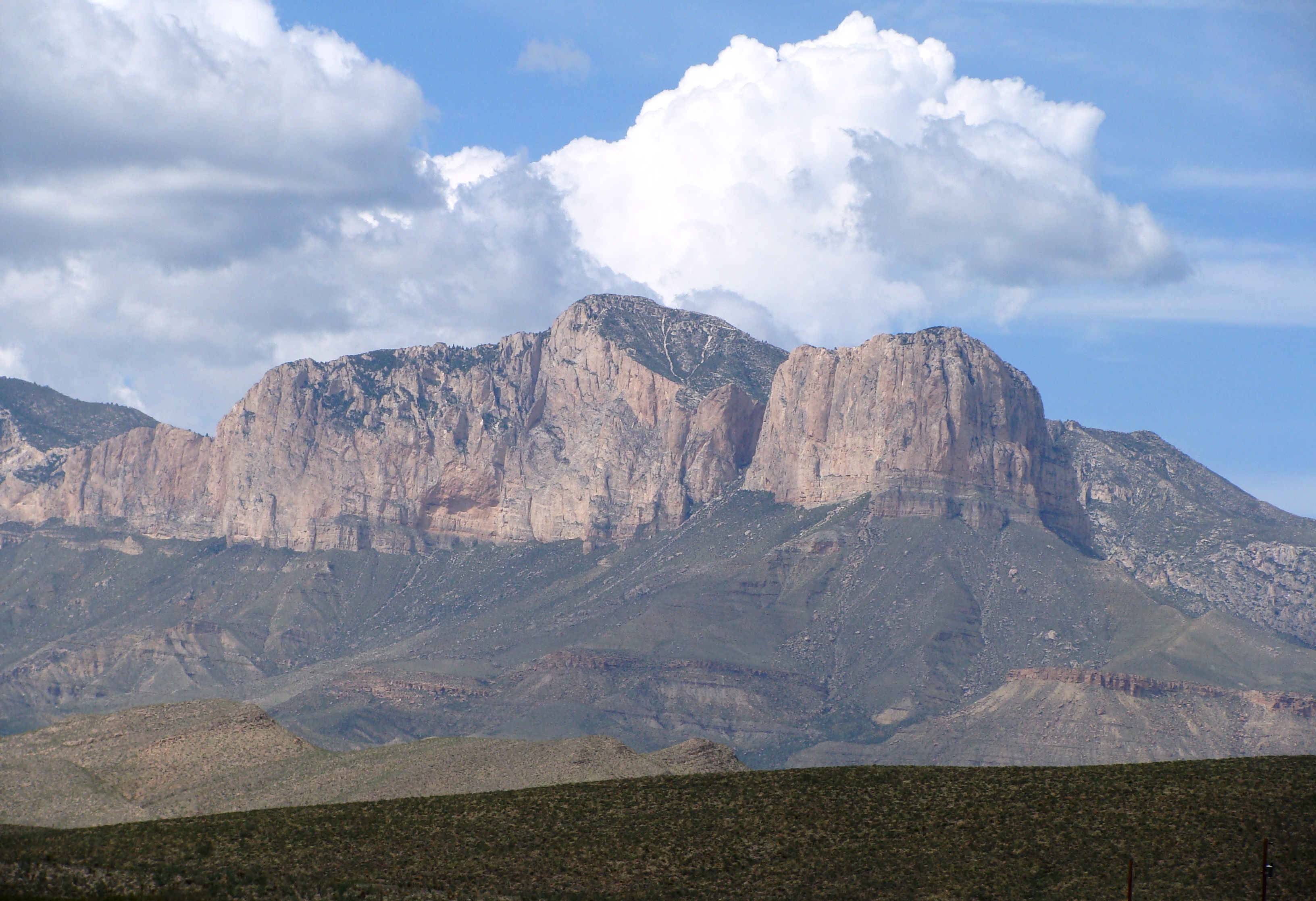
Mount Lemmon is located in the Coronado National Forest in the Santa Catalina Mountains just north of Tucson, and it was named for botanist Sara Plummer Lemmon. As we traversed this scenic byway we were struck by the breathtaking and continually changing topography at every turn in the road. There are a number of scenic pullouts and overlooks on the way up and down the mountain that treat visitors to an ever-changing perspective of the beauty that is uniquely southern Arizona.  It is also a challenging ride for bicyclists; we saw many of them pedaling their way to the top – 9,171 feet above sea level.

DSC04353 (2)

It’s hard to describe the geology because it is so different from the Colorado Rockies and the other mountain ranges we have travelled so far. We found ourselves marveling as we drove through the vegetation of the Sonoran desert to the foothills of Mount Lemmon from which sprang deciduous trees and evergreens. The contrast between the various steep and sharp-crested mountain ranges like the Colorado Rockies, and the exposure to mile after mile of unusual granite boulders left us awe-struck as we traveled through this fantastic mosaic of remarkable landscapes, both beautiful and complex at the same time. The rocks look like they have been hand-painted; some of the rocks are hoodoos (also called tent rocks, fairy chimneys or earth pyramids) – a marvel to behold! Hoodoos are tall, thin spires of rock that protrude from the bottom of an arid drainage basin or bad land – just like you would see in Bryce Canyon National Park in Utah. Their bodies look like totem poles. The size, the color and the quantity of hoodoos on the road to the top of Mount Lemmon are breath-taking.  Other formations look improbable – how is that rock sitting up there so precariously?

DSC04333 (3)

DSC04334 (2)

DSC04335

DSC04336 (2)

DSC04349 (2)

The Palisades Visitor Center is about half-way up the mountain, and it’s a good place for a break and an opportunity to chat with a ranger. After our brief stop, we headed to the summit. The closer we got, the cooler it became and we were treated to some snow when we got near the summit. Not enough snow for skiing or sledding today but still a pleasant surprise after the 70 degree temperatures of the desert floor.

DSC04341 (2)

DSC04343 (2)
Ski Slope On Mount Lemmon

The road to the observatory was closed to vehicles, but some brave and energetic souls hoofed it up the 1.5 miles to the top. We made it about halfway before our energy and our shortness of breath got the best of us.

dsc04510 (2)

The car ride down the mountain was equally enjoyable, and we stopped at the spot named Windy Point – a favorite place for a lot of travelers.  We felt like Rocky Mountain sheep as we leaped across the rocks to find a place to just sit and to take in our surroundings. So peaceful and pleasant. A great day for an outing in the mountains.

We rode our bikes downtown and partially around the 135-mile paved walk/run/bike path that circumvents the town and through Catalina Mountain State Park.  We enjoyed the stalagmites, stalactites, and bat roosts in the Kartchner Caverns (no photos allowed); hiked Sabino Canyon and Madera State Park, both of which have enough of a water supply to support a pine and hardwood forest (in the middle of the desert!), and leisurely explored the Tucson and Tohono Chul Botanical Gardens.  So many beautiful views and vistas!

Kartchner Cave 1 (2)

DSC04088 (2)

DSC04219 (2)

DSC04257 (2)

DSC04245 (2)
Sabino Canyon
DSC04252 (2)
While Hiking Sabino Canyon
DSC04258 (2)
Tohono Chul Botanical Gardens
DSC04274 (2)
Tucson Botanical Garden
DSC04277 (2)
Tucson Botanical Garden
DSC04300 (2)
Tucson Botanical Garden
DSC04309 (2)
Tucson Botanical Garden
dsc04473 (2)
Tohono Chul Botanical Gardens
dsc04477 (2)
Tohono Chul Botanical Gardens
dsc04489 (2)
Tohono Chul Botanical Gardens
dsc04514 (3)
Mount Wrightson – Madera Canyon

We were fortunate that the Tucson International Jewish Film Festival was just getting underway while we were in town, and we were lucky to get seats to see “Budapest Noir”, a hard-boiled detective, noir murder mystery film done in Hungary.  We stayed after the film to hear a Holocaust survivor talk about her mother’s courage and her remembrances of being an infant/small child during that time of darkness in Hungary.

Petroglyphs…

DSC04232 (2)

DSC04234 (2)

DSC04236 (2)

DSC04237 (2)

DSC04239 (2)

DSC04243 (2)

dsc04492 (2)

dsc04491 (2)

…and ate Sonoran hot dogs whenever we could, comparing the dogs offered by 5-6 food trucks and restaurants we sought out along our journey.

See the source image

A Sonoran dog consists of a hot dog that is wrapped in bacon and grilled, served on a bolillo-style hot dog bun, and topped with pinto beans, onions, tomatoes, and a variety of additional condiments, often including mayonnaise and mustard; a grilled pepper (varying in heat) is always included, sometimes wrapped in bacon, too!.  Whether at a food truck or restaurant, other condiments are always available: salsa, radishes, guac sauce, cucumbers, hot/mild peppers.  Barbara, who rarely goes out of her way for a hot dog, fell in love with these babies as a 3pm snack!

The most wonderful thing about our time in Tucson was the friends we made.  We came to value those new friends who, on the very first day we set up camp, invited us to happy hour, and we hung with them daily for the 6 weeks we stayed at this campsite.  We look forward to sharing times together again next year.  Yup – we found a place to call home next winter.

Sunsets were pretty special in this neck of the woods, and we leave the Tucson area with just a few more pictures we hope you’ll enjoy.

dsc04540 (2)

dsc04541 (2)

dsc04542

dsc04542 (2)

Barbara and Brian

TUCSON – DESERT ANIMALS

DSC04230 (2)
Welcome To My World!

December, 2018 – January, 2019

Lions and Tigers and Bears?  Not quite, but Butterflies, Hummingbirds, Sand Hill Cranes, Mexican Jays, a thirsty Coatimundi, Red-Headed Woodpeckers, Harris and Ferruginous Hawks, a Scorpion, a Great Horned Owl, a couple of Chihuahuan Ravens, a Belted Kingfisher, Javelina, Prairie Dogs, Big Horn Sheep, an Arizona Thrush, a Lizard or 2, and a Roadrunner all seen during our time in Tucson.  Can I get an “OH MY” just the same?

During our hikes in the region we couldn’t help but notice signs warning us that we might cross paths with rattlesnakes.  But a rattlesnake-human encounter never did occur.  We figured that given this time of year the ‘rattlers and their Gila Monster cousins were hibernating deep underground.  We hope to have a not-so-close-but-encounter all the same sometime in the future.

DSC04403 (2)

A not-to-be missed attraction just south of the Tucson Mountain District entry into Saguaro National Park is the Sonoran Desert Museum.  The name is a misnomer however; this is not a museum but a wildlife preserve set amongst a saguaro desert biome.  As we entered the property we were greeted by a docent and her Harris Hawk.  What a magnificent raptor and terrific beginning to our visit!

DSC04402 (2)
Harris Hawk
DSC04401 (2)
Harris Hawk

The “museum” encompasses 21 acres and has over 2 miles of winding paths taking the visitor past various indigenous land animals.

DSC04425 (2)
Javelina
DSC04429 (2)
Desert Scorpion
DSC04443
Big Horn Sheep
DSC04431 (2)
Tufted Roadrunner
DSC04444
Prairie Dog
DSC04445
Prairie Dog
DSC04448
Ain’t I Cute?

There were several different types of Hummingbirds to observe at their indoor aviary.

DSC04436 (2)

DSC04438 (2)

DSC04439 (2)

DSC04440

If you pay close attention while walking along the paths, you’ll have the chance to see and hear an assortment of birds as well.

DSC04406 (2)
State Bird: The Arizona Thrush

We enjoyed the presentation called Fur, Fangs and Feathers, which gave us an opportunity to see well-trained snake, skunk, porcupine and vulture up close and personal.  The trainers almost had us believing that these animals were cuddly, and would make fine pets.

DSC04434
Ferruginous Hawk

Our day started early so we could see both the 10am and 2pm free-flying raptor shows – honestly don’t miss either.  The trainers have done a fantastic job of working with the birds.  Each show was quite different; the 10am show included trained pattern hunting by Ferruginous Hawks, a Great Horned Owl and Chihuahuan Raven, and the 2pm show was a display of “flock” hunting by Harris Hawks.  We were told to not raise anything above our heads as the birds might mistake that stray arm or child (some parents are pretty stupid) as prey.  Barbara was brought to tears at the beauty of the birds in flight, and the feeling of the wind as the birds did indeed come close to our heads.  Truly fabulous!

DSC04414 (2)
Great Horned Owl
DSC04416 (2)
Ferruginous Hawk
DSC04415 (2)
Ferruginous Hawk
DSC04417 (3)
Chihuahuan Raven
DSC04420 (2)
Chihuahuan Raven
DSC04450 (2)
Harris Hawk
DSC04451 (2)
Harris Hawk

At 9,171 feet Mount Lemmon is the tallest peak in the Santa Catalina Mountains north of Tucson, and in wintertime the snow is consistently deep enough to keep the region’s lone ski slope open (complete with gondola ski lift!)  Never would have thought of Tucson as having enough snow nevertheless supporting a ski slope.  We drove to the ski lift parking lot and started our hike to the summit.  Along the way a Raptor and Belted Kingfisher were kind enough to pose to have their pictures taken.

DSC04346 (2)

DSC04332 (2)
Belted Kingfisher

Ever wonder where birds go when they go south for the winter?  Yeah, us too.  While we can’t answer for all avian species, we do know that upwards of 14,000 Sand Hill Cranes winter south of the town of Wilcox and just outside of Elfrida, Arizona in the Whitewater Draw Wildlife Refuge.

We walked through some substantial muck out to the viewing area, and we were delighted to see maybe 500 or so Sand Hill Cranes near the shore of a pond.  It was glorious to see the cranes in flight, both coming and going from their “watering hole.”  The birds flew in the single file and “v” patterns we are accustomed to seeing with many bird species.  The County had installed binocular telescopes that helped us have a fantastic view of the birds “up close.”  But 500 birds is not the 14,000 as advertised.  While watching the birds we had a chance to have a conversation with another visitor to the Refuge, and we were asked as to whether or not we had visited a farmer’s field a little ways north and east of the Refuge?  Since that would be a big no, we mucked our way back to our car, and off to the farmer’s field we went.  You could hear the Cranes’ symphony well before seeing them.  And yes, there had to be 1,000s of Sand Hill Cranes strutting their stuff for our wonderment.  If you’re a birder (and you’re in the area) this is not to be missed.  In January, Wilcox hosts an annual special event called “Wings Over Wilcox” that might be worth a visit as well.

dsc04455 (3)

dsc04458 (3)

dsc04452 (4)

dsc04461 (2)

dsc04471 (3)

dsc04467 (2)

dsc04468 (2)

dsc04467 (3)

dsc04469 (3)

dsc04466 (3)

One last word on our adventure to see the Sand Hill Cranes.  We learned the hard way that the soil (i.e., muck) in this part of the world is a good part sticky clay that becomes bricklike when dried (wonder how the Native Americans and first settlers made their adobe homes?).  It took us 45 minutes with a high pressure hose to remove the dried dirt from the Jeep.  Lesson learned!

Tucson Botanical Gardens is a small but beautiful oasis in the heart of Tucson.  It is thoughtfully planned with small winding paths that allow visitors to leisurely stroll through a garden of local trees and ground cover, a zen garden, and a xeriscape garden filled with every imaginable succulent plant from around the world.  We were delighted to discover the Cox Butterfly and Orchid Pavilion, home to some amazing orchids that were just beginning to bloom, a wide variety of Butterflies and an Atlas Moth. We had to go through two doors to get into the Pavilion, always cautious that we didn’t inadvertently allow a Butterfly to escape. The room was small and it felt like we were in a sauna:  the perfect environment to produce exquisite orchids and to provide the ideal setting for so many different and colorful Butterflies that flitted in and around the plants and people.  Even though this blog is about animals we’re adding some pictures of the orchids just ‘cuz!

DSC04281 (2)

DSC04284 (2)

DSC04285 (2)

DSC04279 (2)

DSC04291 (2)

DSC04292 (2)

DSC04293 (2)

DSC04286 (2)

DSC04298 (4)
In Your Face, Man!
DSC04294 (2)
Atlas Moth

Gallery In The Sun is an off-the-beaten path art gallery on the west side of Tucson.  See if you can spot the Lizard in the photographs taken at this quaint shop.

DSC04265 (2)

DSC04264 (2)

Hiking up “A” Mountain, this Roadrunner was kind enough to stop a moment in its pursuit of lunch.

dsc04502 (2)

We drove into the Madera Canyon Recreation Area, and we chose the parking lot with the highest elevation to begin a hike along a slowly running stream.  The hike was perfectly lovely, traversing through a pine and hard wood forest speckled with succulents, using rocks to cross the stream 3 times before reaching the end point and turning around to head back.  We saw a different kind of bird that Barbara thought might just be a jay, and when asking some fellow hikers we found that it was a Mexican Jay.  We were disappointed that during the hike we only saw jays, and the tail end of a deer as it loped quickly away from us.

dsc04531 (2)
Mexican Jay

Heading out of the Canyon, we noticed an overflowing parking lot with lots of people, most with cameras, up against a split wood railing.  We had to stop and we were glad we did as this was an avian observation area.

dsc04524 (2)
Redheaded Woodpecker
dsc04536 (2)
Mexican Jay

While watching Jays and Woodpeckers, a Coatimundi sauntered across the compound, climbed up the fence and helped itself to the hummingbird feeder…it must have a taste for the sweet nectar.

dsc04523
Coatimundi
dsc04522
Coatimundi
dsc04525
Sweet Tooth?
dsc04526
Sweet Tooth?
dsc04527
Coatimundi
dsc04528
Coatimundi

Barbara and Brian

TUCSON – LET’S GET A LITTLE NERDY!

dsc04501 (2)

December, 2018 – January, 2019

Local Tucson Nerdy Facts

  1. The name “Tucson” comes from the name originally given to Sentinel Peak (now “A” Mountain) by the Native American Tohono O’odham Tribe, Ts-iuk-shan, which meant that the peak had a base darker than its top.
  2. The population of metropolitan Tucson is just under 1,000,000, and the metro area is 9,187 square miles.
  3. Outside Magazine Online called Tucson the Best City for Road Biking in 2010, citing “800 miles of roll-around bike paths” and “300 miles of well-maintained loops.”
  4. Tucson has over 300 days of sunshine per year, and it claims to be the sunniest city in the United States.
  5. Aside from the Amazon Rainforest, it is home to more bird species (1,000) than any other region on earth.
  6. The main campus of the University of Arizona is located in downtown Tucson.
  7. The region has more observatories than anywhere else in the world.
  8. Nearby Oracle is home to Biosphere 2 – a skinner box experiment gone wrong.
  9. The geography is a confusion of desert, pine and deciduous forests; the metro area is surrounded by mountains extending to 9000 feet and covered with snow in the wintertime.
  10. The region averages 12 inches of rainfall per year most of which falls during horrific thunderstorms in late spring and into early summer.
  11. It is home to Davis-Monhan Airforce Base, and it is 68 miles from the Mexican border.
  12. The city itself bisects the Saguaro National Park; the region is home to the largest concentration of saguaro cactus in the world.
  13. According to the American Lung Association, Tucson has the third cleanest air of all cities nationwide.
  14. There has been a Jewish population in Tucson since the 1860s, and there are estimated to be 30,000 Jews living in the metro area today.  The Jewish Community Center is one of the finest we’ve ever seen.
  15. The average high temperature in January is a moderate 64 degrees, and it soars to over 100 June-August and stays in the 90s during May, September and into early October.
  16. There are 128 parks in Tucson and when the weather is reasonable it’s hard to not be outdoors!

Not enough nerdiness (or a social studies lesson as Elyssa puts it?)?  Read on!!

DSC04139 (2)

Biosphere 2 is an American earth system science research facility located in Oracle, Arizona whose mission is to serve as a center for research, outreach, teaching, and lifelong learning about Earth, its living systems, and its place in the universe.  It is a 3.14-acre structure (pi?) originally built to be an artificial, materially closed ecological system, or vivarium, and it remains the largest closed system ever created.  The key here is a “closed system;” i.e., 8 research scientists (“biospherians”), flora and fauna representing Earth’s 7 biomes, as well as all needed supplies were sealed into biosphere for 2 years.

DSC04146 (3)
Biosphere 2 Campus – Frontside
DSC04150 (3)
Biosphere 2 Campus – Backside

Biosphere 2 was created to explore the complexities of interactions within life systems in a structure with different areas based on various biological biomes.  In addition to the several biomes and living quarters for people, there was an agricultural area and work space to study the interactions between humans, farming, technology and the rest of nature as a new kind of laboratory for the study of the global ecology.  As an experimental ecological facility it allowed the study and manipulation of a mini biospheric system without harming Earth’s biosphere. Its seven biome areas were a 20,000 sq ft rainforest, a 9,100 sq ft ocean with a coral reef, 4,800 sq ft mangrove wetlands, 14,000 sq ft savannah grassland, a 15,000 sq ft fog desert, and two anthropogenic biomes: a 27,000 sq ft agricultural system and a human habitat with living spaces, laboratories and workshops.

DSC04147 (2)
Rainforest Biome
DSC04148 (2)
Savannah Grassland Biome
DSC04149 (2)
Fog Desert Biome

Below ground is an extensive part of the technical infrastructure.  Heated and cooled water circulated through independent piping systems, and passive solar input through the glass space frame panels covered most of the facility; electrical power was supplied into Biosphere 2 from an onsite natural gas energy center.  Fresh air was supplied through an ingenious warehouse-sized bladder whose movement forced circulation across air handlers and throughout the physical plant itself.

DSC04142 (2)
View Walking To Biosphere 2
DSC04144 (2)
View Walking To Biosphere 2
DSC04151 (2)
View Walking To Biosphere 2

Biosphere 2 was only used twice for its original intended purposes as a closed-system experiment: once from 1991 to 1993, and the second time from March to September 1994. Both attempts, though heavily publicized, ran into problems including low amounts of food and oxygen, die-offs of many animals and plants included in the experiment, group dynamic tensions among the resident crew, outside politics and a power struggle over management and direction of the project. Nevertheless, the closure experiments set world records in closed ecological systems, agricultural production, health improvements with the high nutrient and low caloric diet the crew followed, and insights into the self-organization of complex biomic systems and atmospheric dynamics.  The second closure experiment achieved total food sufficiency and did not require an injection of oxygen.

DSC04141 (2)
Petrified Wood Specimen
DSC04153 (2)
Barbara Loved This Rock!

The most fascinating Biosphere 2 display demonstrated the viability of closed ecological systems and the use of closed biospheres in space colonization; i.e., to support and maintain human life in outer space.

The University of Arizona assumed ownership in 2003.  By the way Biosphere 1 is earth.  Biosphere 2 reminded Brian of a grand Skinner Box experiment!

Let’s not forget the 1996 Pauly Shore comedy film Biodome.  The movie is described as “moronic best friends get themselves locked inside the Bio-Dome along with a group of environmental scientists for one year.  Hilarity results.”  We think the phrase moronic best friends describes the movie perfectly, but take a look and see if you agree.

DSC04354 (2)

Tombstone and Bisbee are 2 towns south/southeast of Tucson and on the way to the Mexican border.  Yeah – the Tombstone of the legend of Wyatt Earp, Doc Holiday and Bat Masterson, and the shootout at the OK Corral.  We heard that attending the shootout and/or visiting  Boot Hill was not worth the time or expense; it’s expensive, the shootout is far too brief, it’s pretty cheesy.  We took a pass.

We first heard about Brisbee when we were in Austin with our nephew Jon and his loving family: Lucy, Lily and Bennet. One of Jon’s friends highly recommended Bisbee, an old copper mining town.  The Queen Mine was open for 98 years before it ceased operation in 1975. The drive to Bisbee was rather dull (or have we just become jaded by all the beauty that is uniquely Tucson?).  However, once you drive through the short tunnel that is the gateway to the city, the landscape changes and is reminiscent of any number of small Colorado mountain towns like Green Mountain Falls, just west of Manitou Springs; or Idaho Springs, just west of Denver. But Bisbee most clearly resembles the gold mining town of Cripple Creek, west of Colorado Springs. Unlike Cripple Creek, Bisbee was a copper mining town.

Bisbee is worth the trip.  It is a free-spirited place with a thriving arts/music/hospitality scene, amid a remarkably well-preserved historical architectural setting.  It has transformed itself into a chic little walkable enclave of boutique shops and restaurants, and as a result, the City has enjoyed an economic boom.  We enjoyed strolling around the streets of this old town: clothing stores, art galleries, restaurants, a coffee shop and a delightful place where we bought gelato – fox berry with almond. Delicious!  Take a long walk around downtown and you can feel the positive energy.

DSC04373
Downtown Bisbee

Oh yeah – one more fun Bisbee fact. In 1912, Bisbee sanitation was crude and infectious diseases were common. The mining camp suffered frequent epidemics of typhoid and other diseases spread from outhouses, stables and cesspools by the common housefly.
That year, the Commercial Club of Bisbee decided on a civic improvement campaign to eradicate flies, sponsoring a contest and offering cash prizes to the person who killed the most flies. It was a project made to order for Bisbee’s kids. The Bisbee Daily Review described the campaign: “…the local fly swatting is at the germ bearing insect that carries dread typhoid and other nasty disease from filthy refuse into one’s food. [It] is the death messenger, the common house fly.” The contest rules were simple: kill, capture or poison flies, put them in a container and turn them in to a local drug store. Officials there counted and tallied the flies for each contestant.

DSC04374 (2)
Icon Representing The Great Bisbee Fly Swatting Contest of 1912

DSC04375 (2)

But what put Bisbee on the map is the rich supply of copper ore found in the hills surrounding the town.  It didn’t hurt that gold, silver, lead, and zinc ores were also part of the area’s underground treasures, and some mines are still in operation today.

We had made reservations to tour the Queen Mine.  We arrived early and were glad we did because there is no street parking on either of the main streets of Bisbee. We drove around some interesting one-way and narrow streets until we found an opening in one of the lots. Once inside the old mining building, we got our tickets for our tour, and we entertained ourselves looking at the wide array of old mining equipment, a short film about mining in Bisbee, and the geologic specimens from the area and from other parts of the world – a remarkable and beautiful collection.

The Queen Mine closed in 1975, and the mine tour became a primary attraction in Bisbee.

DSC04371 (2)
How Valuable Was The Queen Mine?

We had to sign a waiver acknowledging the potential for danger going into an old mine before our guides prepared us for our tour by outfitting us with a hard hat, fluorescent vest, and a miner’s headlamp.

DSC04355

We rode into the mine accompanied by 2 of the miners, Dave and Bill who grew up and lived their whole life in Bisbee; they had worked the Queen Mine when it was in operation. We straddled a narrow bench on a former mine coal train, listened for Dave to ring the bell, and we began our jerky descent underground. We had to keep our knees and hands close as the opening into the mine was very narrow. Once we were fully inside, Dave stopped the train and asked if anyone was having second thoughts about continuing the tour, perhaps feeling a bit claustrophobic, and wanting to exit the tour. Surprisingly no one left the tour so we proceeded on.  Dave spoke lovingly about Bisbee and the history of mining in this small community. He was born, raised and has spent his whole life here, and  hewent to work in the mines as a young man. He was very knowledgeable about the history of the mine, the evolution of the equipment used to mine the ore, the use of dynamite, and the friendships between the miners. He shared some personal stories with us along the way and answered lots of questions. On two occasions, Barbara thought she smelled lavender in the mine. We had heard that there was a nearby “lavender pit” and thought perhaps that was what she was smelling. However the lavender pit is a former open pit copper mine near Bisbee and has nothing do with the fragrance of the lavender that she smelled.  Dave said many aromas are experienced in the mine because of the way the air shafts are set up and the way the air wafts throughout the caves. On occasion Dave said he can smell the odor of coffee from the local coffee company whenever they roast coffee beans. He speculated that Barbara was smelling something from one of the local soap or fragrance shops.

DSC04357 (2)
Small Amounts Of Ore Remain In The Walls Of The Mine
DSC04370 (2)
Small Amounts Of Ore Remain In The Walls Of The Mine

Following our tour we took a picnic lunch to the town park and enjoyed being back in the sunshine. We talked about what it must have been like to be underground 8-12 hours-a-day extracting a daily quota of up to 10 tons of rock for an entire working career.  Grueling!

dsc04495 (2)
In Ann Arbor It’s The Maize Rage!

The second largest academic department at the University of Arizona is astrophysics, which includes undergraduate and graduate majors in astronomy.  The Flandrau Planetarium, Spencer’s Observatory, Kitt Peak National Observatory (24 optical telescopes and a solar telescope), the Mount Lemmon Infrared SkyCenter Observatory, Steward Observatory, Catalina Observatory, Fort Whipple Observatory, and the Mount Graham National Observatory are in Tucson or a short drive from the city.  Visitors can enjoy exploring the heavens due to the many, many nights of clear skies, as well as the programs conducted by the Kitt Peak and Mt Lemmon observatories.  More formally, scientists and university students from around the world are able to conduct experiments addressing their questions of the Milky Way and other galaxies.  The region is truly remarkable for amateur and professional astrophotography.

Brian didn’t understand the inner workings of a telescope, but the lightbulb went off with our visit to Kitt Peak and the Richard F. Caris Mirror Lab.

dsc04497 (2)

An interdisciplinary team of scientists and engineers working together at the Richard F. Caris Mirror Lab at the University of Arizona produce the giant, lightweight mirrors needed for the latest generation of optical and infrared telescopes.  The largest mirrors being made are 27.5 feet in diameter; 7 of these monsters will be used to construct the giant Magellan telescope.  The process of creating a mirror takes approximately 2 full years in order to achieve the level of perfection needed.  While older processes produces a solid-glass mirror, the mirror lab team uses a honeycomb structure on the inside; made out of Ohara E6-type borosilicate glass that is melted, molded and spun-cast into the shape of a paraboloid in a custom-designed rotating oven.

dsc04496 (2)
Constructing The Oven For Producing An Unfinished Mirror

The mirror lab team has also developed a revolutionary new method to polish the honeycomb mirrors with a deeply curved, parabolic surface that results in much shorter focal lengths than conventional mirrors.  Such fast mirrors improve telescope performance a thousand-fold.

dsc04498 (2)
Rough Polishing Machine
dsc04500 (2)
Finishing Polishing Machine

Kitt Peak National Observatory supports the most diverse collection of astronomical observatories on Earth for nighttime optical and infrared astronomy and daytime study of the sun.

DSC04317 (2)

DSC04318 (2)

The scientists operate three major nighttime telescopes and host the facilities of consortia (universities throughout America) which operate 22 optical telescopes and two radio telescopes.

DSC04320 (2)

The McMath–Pierce reflecting solar telescope is the largest solar telescope and the largest unobstructed aperture telescope in the world.

DSC04319 (2)
Solar Telescope: The Sun’s Image For Study Is Projected Onto A Large Table 6 Stories Underground – It takes That Distance To Cool The Image Sufficiently

Fortunately we were able to attend an evening “star” gazing program.  The ride up to the top of Kitt Peak was spectacular in and of itself; a long steep climb with plenty of switchbacks, with the tall rockface of the mountain and shear drops from the shoulder of the roadway accompanying us during the ride.

DSC04313 (2)

DSC04314 (2)

DSC04316 (2)

Beginning just before sunset we had the chance to hear about the history of Kitt Peak and the planned activities for the evening.  We were told that our vehicle would be equipped with special light blocking screens, and that we would be led 1 mile down the mountain at the end of the program.  No photography was permitted after dark, and we were given “red light” flashlights to use if needed.  Why?  Turns out that any ambient white light will more than likely void any and all current research projects.

We began with a short walk to watch the sunset.  Here’s a trick question from our guide: In what direction does the sun set?  Most of us went with the obvious answer: west.  The smarter of us said the correct answer of southwest; the compass direction of sunset is dependent on the season.  Next questions: when does sunset actually occur? what are the blue and red bands in the sky just before sunset?  And then: why is the moon so bright?

DSC04327 (2)

DSC04325 (2)

After a brief introduction on how to use a night sky mapping tool to identify the stars and constellations that could be seen by the naked eye tonight, our guide tried to convince Brian he could complete proper gestalts…wrong!  He was lucky to be able to differentiate a plane flying by from a star.  We then had the chance to use high-powered binoculars and guess what?  The veil began to rise – we saw part of the Milky Way, lots and lots of individual stars and star clusters, got a close-up of the moon, and, guess what?  Mars is really red!

The last part of the program was without a doubt something special.  We got to look through a telescope at a star, a group of stars forming the pattern of a Christmas tree, a nebula, a star being formed, and the moon.

The program got better and better as the time wore on and it became totally fascinating.  Brian could have looked through the large telescope for hours!   We highly recommend the program, and we kept talking about what we saw for days.

Barbara and Brian


CACTUS

DSC04226 (2)

December, 2018 – January, 2019

The Sonoran Desert is an arid region covering approximately 100,000 square miles in southwestern Arizona and southeastern California, as well as most of Baja California and the western half of the state of Sonora, Mexico.  The saguaro cactus is the signature plant of the Sonoran Desert.

Saguaro National Park is part of the Sonoran Desert, located in Pima County, Arizona.  The 92,000-acre park is pretty much bisected by the City of Tucson — the Tucson Mountain District about 10 miles west of the city of Tucson and the Rincon Mountain District about 10 miles east of the city.  The park exists to preserve the Sonoran Desert landscapes, fauna, and flora, and especially the giant saguaro cactus.  Tucson has been called the cactus kingdom of dreams (Andi Berlin, 2018)!

Preserving the landscapes of the desert is not unique to the Park alone.  Mother Nature has been and is actively at work and clearly focused on making sure that if the landscape is below 2000 feet above sea level, without a visible running water source most of the year, and not covered in concrete or macadam, cholla cactus, agave, barrel cactus, yucca, the palo verde tree or mesquite tree, and, yes, saguaro cactus find a way to root into a speck of land and thrive.

However, in the area near metro Tucson there are canyons with running streams and brooks.  In those preserves juniper, oak, douglas fir, white fir, quaking aspen and sycamore trees can be found.  The species of birds and mammals is very different from that found in the desert – and the temperatures are generally cooler, particularly in summertime.  Mt Lemmon and Mt Wrightson both rise more than 9000 feet above sea level, and they were covered in snow during our time in the area.  Mt Lemmon had a 60- inch snow base and the ski slope was open!  But enough about that for now – this blog is about cactus.

DSC04097 (2)

There are visible differences between the east and west sides of Saguaro National Park.  Sure, we had to show our National Parks pass at the Rincon Mountain District gate to enter the east side of the Park.  We drove directly into the Tucson Mountain District (west) part of the park.  For reference there are visitors centers at each of the parks.  But that’s not the primary difference.  We calculated the numbers of saguaro cacti in each side of the park and determined that the density is higher in the east.  And most of the saguaros in the Rincon Mountain District had “arms”; that wasn’t the case in the Tucson Mountain District.


DSC04076 (2)

DSC04071 (3)

DSC04078 (2)

DSC04090 (2)

DSC04092 (2)

DSC04256 (2)

DSC04216 (2)

DSC04255 (2)

One of the things we noticed as we drove toward the Rincon entrance to the eastern part of the park was the large number of bicyclists on the road.  We thought that perhaps we had made a mistake in not bringing our bikes along.  After a brief stop at the visitors center for information and to watch a short film, we took the one-way, eight-mile drive on the Cactus Forest Loop around the park.  The Loop is a narrow, hilly challenging paved road with many sharp turns, which firmly convinced us that we made the right choice in not bringing our bikes.  Trying to ride our commuter bikes would have been very challenging if not near impossible – they’re just not set up for that kind of ride.  We stopped for lunch at one of the trailheads that had a peaceful and pleasant view of the snow-capped mountains in the distance.  After lunch we ventured out on a short hike among these magnificent giants.

As you open yourself to this place and the wonderous desert, the saguaro grow on you, and it’s hard not to anthropomorphize the saguaro and other cacti. Some seem to be welcoming you with their open arms. Others are standing like little kids peeking out from behind their mother’s skirt; some are arranged as a family, some solitary and alone; some are bent to symbolize their age and the effect their years of labor and toil have taken, and yet others stand in majesty declaring their rightful place in this world.

DSC04081 (2)
We Welcome You With Open Arms!
DSC04083 (2)
Shy Guys!
dsc04482 (2)
Anyone Else See The Elephant?
dsc04480 (2)
I See You!
DSC04218 (2)
Bent Over From Years of Toil
DSC04384 (2)
I’d Like You To Meet The Family
DSC04377 (2)
More Shy Guys

DSC04304 (2)

When you hear about the history of the area and realize the importance of the saguaro to the First Nation Peoples, the Tohono O’odham, it makes you look at saguaro with a different eye.  The Tohono O’odham hold the saguaro in the highest regard.  The cactus provides sustenance year-round and hydration during the brutally hot and dry summer season, but in their belief the saguaro become sacred as the living legacy of their past; representing forefathers and foremothers, the many generations who thrived in the shadow of the saguaro.  To the Tohono O’odham when you walk amongst the saguaro you are walking among friends who welcome you with uplifted arms.  In respect for their traditions and beliefs we bring no harm to these mighty and ancient giants.  L’Dor Vador.

Like every living thing, the saguaro have a life span. Some may live to be 200 years old; others die because of disease or other forces of nature. During their lifetime their fruits provide nourishment to man and beast, and they provide a home for birds and other desert wildlife. But even in death, the skeletal remains continue to have purpose and function. Saguaro ribs have been used to build houses.  The ribs are strong but lightweight enough to be used as roofing material over a stone structure.  The woody ribs serve many practical functions as well: splints for broken bones; canes or walking sticks, and they are often incorporated into cradles for babies.

DSC04221 (2)

DSC04220 (2)

What’s the big deal about cactus having arms?  They grow their first side arm any time from 75–100 years of age (sure, some don’t ever grow arms).  Arms are developed to increase the plant’s reproductive capacity, and it leads to more flowers and fruit.  Saguaros may grow to be over 40 feet in height.  Saguaros with arms are older than those without (called spears).

One more word before pictures from our hikes in the Park.  There are untold numbers of spears (no arms) and mature (arms) saguaro. The crested saguaro, however, is rare.    Even when saguaro cacti grow in their normal form, they rarely grow symmetrically, and sometimes an odd or misshapen form, looking like a fan, will top the saguaro.  This is referred to as crested (cristate) saguaro.  The Rangers estimate that there are only 25 crested saguaro in the entire park.

dsc04479

DSC04381 (2)

We marveled at the variety of other cacti in the park.

DSC04079 (2)

DSC04217

DSC04222 (2)

DSC04227

DSC04260 (2)

dsc04483 (2)
Looking Down Into The Center Of A Barrel Cactus

DSC04305 (2)

dsc04474 (2)

We got up way early one morning to experience the saguaro at sunrise.

DSC04383 (2)

DSC04384 (2)

DSC04386 (2)


DSC04392 (2)

DSC04393 (2)

DSC04394 (2)

DSC04395 (2)

DSC04396 (2)

DSC04397 (2)

DSC04390 (2)

We had timed our visit to enjoy the setting sun, too, and hoped we would get to see some wildlife, (javelina, fox or rabbits), but it was either too or cold or our timing was off. We were not disappointed at all; it was a glorious way to spend a few days in the desert.

DSC04096

Barbara and Brian


TUCSON: CELEBRATE ART

See the source image


December, 2018

We dedicated an entire blog to the wonderful murals and street art in Austin.   Turns out that while spending time at the Tucson Visitors Center we were delighted to find that Tucson has paid tribute to sculpture as well as spray paint and brushwork on the sides of buildings, and that the Visitors Center provides a “Celebrate Art!” bike map that would serve as our guide.  We took a day on our bikes to discover the many murals and a few sculptures in and around downtown Tucson.

We parked our car in the community college parking lot near Santa Cruz River Park and unloaded our bikes.  Santa Cruz River Park is a stop along the Tucson Loop,  a 130-mile, multi-use paved path that circumnavigates the perimeter of the city.  Bikes, skateboards, walkers, and even horses are welcome on these beautifully-maintained paths.

As newbies to the city of Tucson, we were unfamiliar with the streets and avenues, and we discovered that some murals were a challenge to find.  Mural 4, for example, was not at 310 West Alameda as advertised but rather behind the Tucson Water Building at 300 West Paseo Redondo.  We pedaled on, and we were successful in finding quite a few murals fairly easily.  The logic of the self-guided biking/walking tour began to make sense!  However, just when we were feeling confident, we’d feel lost again.  But persevere we did, and we were able to complete the bike tour.

Check it out!

DSC04158 (2)

DSC04156 (2)

DSC04157 (2)

DSC04159 (2)


DSC04160 (2)

DSC04164 (2)

DSC04166 (2)

DSC04168 (2)

DSC04169 (2)

DSC04170 (2)

DSC04171 (2)

DSC04172 (3)


DSC04178 (2)

DSC04182 (2)
This Mural Changes With The Performance Scheduled.

DSC04183 (2)


DSC04191 (2)

DSC04192 (2)
Mr. Miyagi?

DSC04196 (2)

DSC04197 (2)

See the source image

DSC04198

DSC04202 (2)

DSC04203 (2)

DSC04204 (2)

DSC04201 (2)

We found our targets all over the city, but we will remember the one tucked away in the alley behind Miller’s Army Surplus Store.  We want to give the owners a shout-out “thank you” for having a secured and clean port-a-potty!

DSC04132 (3)
Can You Name Them All?
DSC04134 (2)
Can You Name Them All?

DSC04131 (2)

DSC04138 (4)

DSC04186 (4)

DSC04186

DSC04187

DSC04185 (2)
Reflection In A Club Window. Mural Is Across The Alley.

As with any adventure there are added bonuses.  We also found several pieces of street art that ought to become part of the “Celebrate Art!” mural tour: one at 412 6th Avenue; two at 7th Street and 6th Avenues, three colorful murals at West 6th Avenue and Toole just before you drive under the overpass near the rail station; four small, very well-crafted murals behind The Independent Distillery on Scott Street.  And we found a mural that gently reminds everyone to “Be Kind”.

DSC04188 (2)

DSC04189 (3)
How Funny Is This?
DSC04190 (2)
Advertising A Bar

DSC04199 (2)

The “Celebrate Art” tour takes the visitor past murals and street art in the general downtown area.  Throughout the larger Tucson metroplex there are murals and street art just waiting to be seen.

DSC04200 (2)

DSC04194 (2)

See the source image

Comparisons between the art we found in Austin and Tucson is inevitable.  Brian would describe the murals of Austin as driven by the artist’s culture, full of emotion and gonzo in design.  Mural art in Tucson is a bit more on the serious side, can be whimsical and representative of the community.  Indeed different, and we strongly recommend not missing either.

It took us three hours to complete our tour on a beautiful bright sunshiny December day in Tucson, and it was well worth the effort.

Tucson is one of the bike-friendliest cities we’ve experience.  There are bike lanes literally everywhere.  While the biking experience in Tucson may not be as thrilling or challenging as say a bike tour through Bryce Canyon, seeing Tucson on two wheels is  highly recommended.

TUCSON

See the source image

December, 2018

Interstate 10 runs all the way from Jacksonville, Florida to Los Angeles, California.  There are other interstate routes that follow the east-west path across the U.S., but none more southerly than I-10.  We figured that following the path furthest south should mean warmer weather, and warmer weather is definitely one of our wintering goals.  We’ve written before that we’re on the way to the San Diego area.  Tucson is a metropolitan area along I-10.  And it’s December.  We planned on staying 6 weeks.

See the source image

But where to set-up and camp in a snowbird’s winter haven?  We began by looking for possible RV parks recommended by the clubs to which we belong:  Good Sam, Passport America and Escapees.  Then time was well-spent checking and double checking the various RV park rating websites to narrow down the search.  Most importantly we read what other campers had to say about campgrounds, and to be sure to check the dates of the reviews.  Poor reviews in 2010 or even 2015 will reduce an overall rating even if everything other campers say about the Park in 2017-2018 is 5-star.  And staying a month or more results in a more favorable camping fee.

Tucson Meadows is a full-service 55 and older senior living community in which the majority of sites “up front” are occupied by “park models,” and “in the back” there are 100+ sites for RVs.  Park models are single-family retirement homes that are double-wide (or 2 connected double-wide) trailers, skirted and landscaped.  There’s a clubhouse with room for community-wide events such as a monthly pancake breakfast, donuts and coffee every Thursday; card/game room, line dance lessons, karaoke parties, sock hops, a well-stocked library, a full kitchen, aerobics and Zumba classes; sit-around-the-fireplace- and-schmooze space, staff office and a small workout room with a multi-station weight machine, dumbbells, 4 treadmills and weighted balls.  There’s a heated pool, competitive shuffleboard court, 2 hot tubs, and a ramada for smaller gatherings.  Streets are wide and easy to maneuver even for the largest diesel pusher.

While setting up, our neighbors stopped by to introduce themselves and to invite us to a nightly (weather permitting) happy hour.  Just bring your beverage of choice and a chair.  Turns out some of our neighbors have been coming to Tucson Meadows many, many years.  This is the kind of warm greeting we had hoped for and had not found in other parks, and we knew it would make for a wonderful stay.  Guess we have to hang out with people our own age?

There’s always so much to see and do wherever we have camped, and Barbara wonderfully puts together our list of possibilities.  It’s always a matter of how long we’ll be at any one location as to what on the list we take our time finding and exploring or if we exhaustively cram in the sites we shouldn’t miss.

Bet you thought we’d start the blogs about our time in Tucson with our outdoor hikes sojourning with cactus and other desert plants and animals?  Nah – take a look at Tucson weird with a couple of museums we couldn’t pass up,  spend a little time outdoors, and then spend a long minute with Judaism.

DSC04099 (2)

The Ignite Sign Art Museum is an eclectic assortment of signs that started as the personal collection of Jude Cook, who has spent his life in the design and sign industry.  Over the course of 40 years, Cook collected signs from across Arizona and the U.S., and he acquired a reputation as the person to call when you needed an old sign hauled off quickly.  After his collection grew too large to store, he decided to put it on display for everyone to enjoy.  There’s neon, electric, hand-painted, aluminum, and LED signs that run the gamut from historic neon to rescued commercial business signs.  His wife shares his love of all things signs, and as the museum’s docent, she is a wonderful guide through the museum.

DSC04100 (2)

DSC04101 (2)
Miniature Reproductions Of Signs In Tucson
DSC04102 (2)
Miniature Reproductions Of Signs In Tucson
DSC04103 (2)
When’s The Last Time You Saw A Sign For Falstaff Or Stroh’s Beer?

DSC04104

DSC04105 (2)

Brian planned on being pretty bored by the exhibits housed in The Mini Time Machine Museum of Miniatures.  Even the name seems to be somewhat boring, and it created  images for him of grown bespectacled creepy obese men and pinched women playing with dollhouses, their furnishings and wee dollies well into their elder years.  But, hear Brian clearly: “I was wrong!”

DSC04107 (2)

The museum displays the intricate work of well-skilled craftsmen and women whose life’s passion is the make-by-hand amazingly accurate miniature replicas of houses and roomboxes.  The collection was a lifelong hobby and devotion of Patricia Arnell whose home was filled with the miniatures on display.  The museum was founded in her memory by her children.  In all there are over 275 displays spanning a period of 250 years (that’s right – going back to the 18th century!).

DSC04127 (2)
Amazing Detail In Every Room
DSC04123 (3)
A Dress Shop For Little Girls
DSC04109 (2)
Santa’s Workshop
DSC04114 (2)
This Display Is 12 Foot Across And Below Floor Level
DSC04115 (2)
A Faerie’s Music Room
DSC04116 (2)
Ready For Halloween?

DSC04118 (2)

DSC04119 (2)
Geppetto and Pinocchio
DSC04120 (2)
Southwestern Bedroom
DSC04124 (2)
Art Deco New Year’s

DSC04125 (2)

Mat Bevel’s Museum of Kinetic Art is a fascinating world of sound, light, motion, thought, intrigue, and ingenious creativity – art and science intersect in strange and satisfying ways (so says the artist!).

Beveldom 1

Beveldom 3 (2)

We were fortunate to be able to attend the opening of the museum at its new location and to hear the artist describe his work.  The sculptures take shape over a number of years and each is composed of “found objects, always changing and always capable of being in motion.”  The artist admitted to having to buy “hardware” such as hinges, nuts and bolts, screws and occasionally wood to complete a piece, but all sculptures are composed of stuff you’d find on the roadside, in junk yards, or in landfills.  Absolutely fascinating!  And did I mention that everything moves?

Beveldom 4 (2)
Check Out The Shadow
Beveldom 5 (2)
Jaws?

Beveldom 7 (3)

Beveldom 8 (2)

Beveldom 9 (2)

Beveldom 10 (2)

Beveldom 15 (2)

Beveldom 11 (2)

Beveldom 13 (2)
Mat Bevel Loves His Butterflies

Beveldom 14 (2)

Beveldom 12

Diamondback Bridge is a walkway that offers pedestrians a way across a busy highway in downtown Tucson.  Built in 2002 the structure was designed by a local artist who wanted to incorporate the local wildlife into his city project.  The bridge, while abstract, is also quite biologically accurate – the entrance to the bridge is shaped like the snake’s gaping maw, the long fangs presented as support beams below sinister reptilian eyes.  The bridge itself is covered by a metal mesh which forms the snake’s body which is painted in the exact hues and gradient of a real rattlesnake.  In addition, cars passing beneath the span can see the accurately spaced segments of the beast displayed on the belly. Coming out the… other… end of the snake, there is a tall statue shaped like a tail rattle that juts 30 feet out of the ground, also sculpted and painted biologically correct.

DSC04267 (4)

DSC04268 (2)

DSC04271 (2)

The Jewish History Museum/Holocaust History Center was once home to the first synagogue in the Arizona Territory: Temple Emanu-El (1910-1948).

DSC04376 (2)

Two buildings make up the Center: one that tells the story of the early Jews in Southern Arizona and the other the Gould Family Holocaust History Center.  Each used multiple mediums.   The Jewish History Museum occupies the renovated Temple building, and it is centered by a representation of the original synagogue.  There are stained glass windows highlighting Jewish icons, an altar (bima) with lectern, pews and an open Torah on display.  In the back are other holy scriptures such as a Passover Haggadah and a-turn- of-the-20th century prayer book.

After watching a short film, we moved to an “archive and listening station.” With headsets we listened to the voices of local Jews and non-Jews describing situations in which they experienced discrimination.  The recordings presented span both historical and contemporary situations at the individual, societal and institutional level.  The goal of this exhibit is “to illuminate both the connections and divergences that exist across systems of discrimination.”  There were testimonials by Tucson residents of discrimination, anti-semitism, exclusion and isolation.  We were invited to listen to recordings of Jewish music, played on old LPs, and we saw some beautiful and treasured artifacts on display throughout the museum.  There was also a genealogy montage featuring ancestral photos contrasted with contemporary family photos.

The Gould Family Holocaust History Center is stark, low lit and has an industrial feel that created an atmosphere of dread and seriousness.  We were astounded by the number of Holocaust survivors (260 from 18 nations) who came to live in Tucson after the war, and who courageously recorded their family stories of horror and survival in the ghettos and death camps in Europe during World War II.  The wall of remembrance pays honor to these courageous individuals, and it serves as a living memorial to those whose lives were forever changed.  A portion of the Holocaust History Center is committed to educating the public about people throughout the world who are today’s victims of “ethnic cleansing”, a polite word for genocide.  The Holocaust Center’s efforts this year are a collaboration with Jewish World Watch to educate and to tell the world about the genocide of the Rohingya Muslims.

The Museum is also an educational institute with the goal of examining the Holocaust through the lived experiences of survivors and through contemporary human rights issues.  Middle school and high school groups are encouraged to come to the Museum to hear first-hand what it was like to grow up in a country that isolated, vilified and murdered Jews, and to begin a dialogue with students about antisemitism today.

The Jewish Museum has also become a safe place for difficult conversations about many forms of oppression (antisemitism, heteronormativity, immigration, Islamophobia, privilege), and the Museum is recognized as a safe place for addressing and encouraging discussions about the interconnectedness of all forms of discrimination.

The docents were warm and welcoming and they were eager to make our visit memorable. They succeeded.

Barbara and Brian


MISSILES ANYONE?

November, 2018

We’re on our way to San Diego for a long overdue visit with Graham and Leigh in their natural habitat…well, for now their natural habitat.  Following our 4-5 hour driving rule the obvious next stop would have been El Paso, but something told us to keep going an extra hour, and to spend some time in Las Cruses instead.  Las Cruses is the second largest city in New Mexico at just a little more than 100,000 souls in far southwest New Mexico, bordering on the Rio Grande and Mexico.

The King of Spain ordered villages be built along the Camino Real (the Royal Road), a path traversing Spanish territory from Mexico City to its northern capitol city, Santa Fe.  Las Cruses was one of those encampments.  Native Americans, Spanish explorers, and Mexican colonists had come in their own time to call this region home, and throughout history, wars had been fought and treaties made for control of the area.  Over the centuries Spain, Mexico, the United States and the Confederacy have all owned this piece of the Sonoran Desert.

Las Cruses is home to 20,000 students attending New Mexico State University (one of the perennial bottom 10 of college football), and the City is jammed packed with all of the chain strip mall stores and restaurants found almost anywhere these days; however, the City has found a way to maintain its old west quaintness and easy slowed down pace of life.

DSC04011

We visited the neighborhoods of the city of Mesilla, which resembled a small Mexican village.  Shops and restaurants around a “town square” are anchored by a mission-style church with residences and schools around the corner from the square.

DSC04014 (2)
Love This Shirt!
DSC04015 (2)
Town Square – Mesilla, New Mexico
DSC04016
Think Billy The Kid And Pat Garrett (Yeah, Really!)
DSC04019 (2)
Mesilla Town Motto: “God Helps Those Who Help Themselves”

DSC04012 (2)

New Mexico was chosen as a rocket testing ground in 1930 when Robert Goddard brought his research program to Roswell (approximately 185 miles northeast of Las Cruses).   In 1944, the government took over the Alamogordo Bombing Range and nearby lands for the new White Sands Proving Ground.  In August 1945 German scientists who had obtained their post-WWII security clearance joined American scientists and began work at the testing ground.  The scientists had confiscated V-2 rocket components to assist in their initial efforts, and the government selected Werner Von Braun to head-up the Army’s Ballistic Missile project.  The proving ground was selected as the missile testing range, and it was renamed White Sands Missile Range.  Covering 3,200 square miles, it is one of the largest military installations in the country.

DSC04065 (2)

The Missile Range is an active US Army Post, and it is generally off-limits to civilians.  An on-post museum  and outdoor display of aircraft, rockets, and a facsimile of the “fat man” bomb casing can be accessed by civilians once cleared.  The process of obtaining clearance took about 15-20 minutes, and included a formal Q&A as well as a background check.

DSC04025 (2)
…And If Lost We’ll Expect You To Glow In The Dark Anyhow…

The museum had 2 nice displays; one dedicated to the Army’s role in settlement of the area by the United States, and several rooms displaying the technology of rocket armaments.  Interesting fact: outdoor photography was ok, but only if we were facing the mountains and away from the actual test range.

DSC04066 (2)

DSC04067 (3)

DSC04068 (2)

DSC04069 (2)

DSC04070 (2)

White Sands National Monument is 275-square miles of desert lying within the area of the Missile Range.  Established in 1933, the great wave-like dunes are made of gypsum sand.  Gypsum is rarely found as sand because it dissolves on contact with water.  Due to the isolation and weather patterns of the region the sands are able to remain and be available for exploring.  We were able to hike on the dunes, observed a playa (alkali flat), and watched a family sled down the dunes.  Barbara remarked that the dunes looked more like snow than sand.

DSC04026 (2)

DSC04027 (2)

DSC04028 (2)

DSC04029 (3)

DSC04030 (2)

DSC04031 (2)

DSC04032 (2)
Check Out That Sky
DSC04036 (3)
A Playa In The White Sands National Monument – Absurd Alkalinity

White Sands National Monument also preserves the plants and animals that have successfully adapted to this constantly changing harsh environment.  While we didn’t see any wildlife (snakes, cougars, toads, road runners), more than 600 species of invertebrates call this protected land their home.  We could only imagine that this jewel cannot become a National Park because of it’s relationship to the Missile Range.

DSC04037

We’ve come to believe that we have some kind of masochistic streak when it comes to hiking.  Hikes up the grade to Clingman’s Dome, up the grade along the Appalachian Trail, up the grade in Hot Springs, Arkansas as well as our getting lost and a 3-5 mile hike turning into 7-10 miles – we must actually love our challenges.  Dripping Springs Trail tested our sanity.  The trail to the springs is a 3-mils loop. We arrived at this State Park nestled against The Organ Mountain Range approximately 1 1/2 hours before the gates were to close.   We asked the Ranger if there was time for us to hike the trail and his deliberation was as follows: “it’ll take you about an hour to hike the trail to the springs, but less time on the way back.  You should be ok.”  Puzzled about the Ranger’s comments, off we went and discovered that it was 1 1/2 miles uphill to the springs.  Not a simple uphill grade, but a breath-taking, calf-burning, take-a-break-every-so-often trek up and up and up an incredibly rocky and uneven path.  The springs were less than overwhelming, but the stories of the settlement near the springs and the views along the way were worth the journey…and yes, coming down took about a third of the time.  We were pretty proud of ourselves for completing this hike.  Even the Ranger stated that we made “good time.”

DSC04038 (3)
Up Hill All The Way!
DSC04039 (2)
Still Heading Uphill
DSC04041 (2)
Guess What? STILL UPHILL!
DSC04044 (2)
That’s Las Cruses In The Valley
DSC04045 (2)
Just A Little Further UPHILL
DSC04048 (2)
The Famous Dripping Springs?
DSC04049 (2)
Ruins Of A Tuberculosis Sanitarium Circa 19th Century
DSC04050 (2)
Burned Cactus Remains
DSC04053 (2)
Coming Back Downhill – Las Cruses in the Valley

Had to stop at the Space Murals Museum.  On the way to the Army’s White Sands Missile Range and White Sands National Monument we passed a water tank with painted murals depicting the progress of the US Space Program from the early flights of the X-15 to the fatal accident of the Challenger Space Shuttle.  Turns out this is a 1.2 million gallon water tank with painted murals encircling the entire tank.  But the real treat is the museum which is jammed packed with memorabilia.  Many personal items have been given to or are on loan to the museum, and more and more items arrive everyday from people who have collected space-related items since the program’s inception during the Kennedy (Eisenhower?) administration.  Lots and lots of autographed pictures, an actual space capsule, solar fan, radio antenna and tower that had been to space, astronaut suits and items used by astronauts during space flight are on display.  There is also a remembrance of the landing of the space shuttle at White Sands National Monument.  Well worth the visit!

DSC04063 (2)

DSC04060 (2)

DSC04056 (2)

DSC04062 (2)

DSC04061 (2)

Quite a lot to see and do in this terrific area of the country.  Highly recommend a visit if you’re in the area.

Barbara and Brian


MARFA, TEXAS

DSC03878 (2)

November, 2018

Yup – that’s right, a town named Marfa.  We heard that Marfa was a sleepy desert town until the east coast artists took over; we heard that Marfa was taken over by hippies in the 1960s and never given back; and we heard that Marfa was the Brooklyn of Texas and filled with hipsters, coffee shops, and expensive real estate.  We had to find out for ourselves.

DSC03879 (2)
Sign Painted On The Side Of A Building Seen Upon Entering Marfa, Texas

Located 90 some miles southwest of Fort Stockton, MARFA’s claim to fame is that the movie “Giant” starring Elizabeth Taylor, Rock Hudson, James Dean, Sal Mineo, Carroll Baker, and Dennis Hopper was filmed here in 1956, and the lobby of the El Paisano Hotel was used as a set for the film.   Marfa Girl (2012) and Marfa Girl 2 (2018) are more recent films about life in this Texas town.

DSC03895 (3)
Downtown  Marfa Texas
DSC03898 (2)
Courthouse And City Hall – Marfa Texas

DSC03899 (2)

DSC03900 (2)
Lobby Of The El Paisano Hotel

Marfa does have a unique dedication to minimalist art, and it is more hip than a city of 1700 in the high desert of the Trans-Pecos in far West Texas ought to be.  Founded on the principles of Donald Judd, the Chinati Foundation is home to extensive minimalist works of art.  Brian tried a joke asking whether or not Donald Judd had lived in Chicago and Cincinnati before settling in Marfa and hence the name Chinati, but the docent replied that he was born, bred and raised in Texas.  The Chinati Foundation purchased a “retired” army base, which became home for his works of art.  The indoor pieces are housed in 2 re-purposed vehicle repair shops; the windows had been the garage doors in their past.

DSC03887 (2)

DSC03880 (2)
Outdoor Minimalist Art – Donald Judd
DSC03881 (2)
Outdoor Minimalist Art – Donald Judd
DSC03883 (2)
Outdoor Minimalist Art – Donald Judd
DSC03894 (2)
“By Faith And Courage”
DSC03889 (2)
Indoor Works Taken Through The Glass – Donald Judd. Note What The Reflection Adds To The Photograph
DSC03890 (2)
Indoor Works Taken Through The Glass – Donald Judd. Note What The Reflection Adds To The Photograph

If minimalism is not to your liking, 2 side-by-side galleries might be more to your taste.  On loan from the Guggenheim Museum SoHo, one gallery was displaying Warhol’s “Last Supper” series of paintings.  Its sister gallery was showing Maria Zerres’ series of 2005 paintings entitled “September Eleventh.”  The galleries are part of  The Ayn Foundation, a wholly-owned affiliate of the Arnulf Rainer Museum in New York City.

DSC03896 (2)

Great times in Marfa!

Barbara and Brian

CARLSBAD CAVERNS AND GUADALUPE MOUNTAIN NATIONAL PARK

DSC03909 (2)

November, 2018

We had heard bad, very bad stories about driving the route from Fort Stockton to Carlsbad Caverns.  Texas Route 285 cuts North/South through the Chihuahuan Desert and into the Guadalupe Mountains, which sounds like it should be a pretty cool ride in and of itself.  BUT, the route is a 1 lane in each direction main thoroughfare for the oil, natural gas and fracking industries of West Texas.  It is poorly maintained and parts are under construction (we figured) for expansion.  It is overrun with fuel haulers, 16-wheelers, heavy mobile equipment, the employed driving their 3/4 and 1-ton pickup trucks with and without trailers attached, and us civilians – not part of the petroleum and natural gas industry wars.  Except for us civilians everyone, and I mean everyone, is in a big city tailgating type of hurry.  One of the comments made to us was that the number of traffic fatalities along Route 285 had increased since the fracking boom hit.

We thought that planning our visit to the Caverns on a Sunday would reduce the volume of traffic on the roadways and would help alleviate the stress of this “route from hell.” Absolutely not true!  A Sunday was bad enough.  Travelling it at any other time would be a white-knuckle experience.  It was after dark when we were heading back to our Fort Stockton campsite, and we couldn’t believe the volume of traffic heading north on a Sunday night.  We could only guess that it was the roustabouts heading in for their Sunday night and/or Monday morning work shifts.

We tried to see past the oil/gas/fracking plants – something had to make the ride more tolerable.  The literature describing the area stated that “as you pass through the Chihuahuan Desert and into the Guadalupe Mountains of southeastern New Mexico and west Texas, the terrain is filled with prickly pear, chollas, sotols, and agaves.”  Sounded like an interesting countryside for the ride .  No such luck as long as we were on Route 285.

Once we were finally able to escape Route 285 we did get to experience the endless desert and the wonder of the mountains.  We had about 40 miles further to travel until reaching the Park; the last 8 miles or so had us passing through the town of Whites City, New Mexico (population 7).  There’s a restaurant, trading post/souvenir shop/dry goods grocer, an old fashioned motel, and a desolate RV campground of about 25 sites all coming together to make up Whites City. We guessed that someone thought it’d be a modern day goldmine as a gateway to the Park.

There are more than 300 known caves beneath the seemingly peaceful surface, and Carlsbad Caverns National Park contains 113 of these caves.  These caverns once served as a coastline for an inland sea. Nearly 250 million years later, the Carlsbad Caverns are the remains of this ancient coastline and the eroded Permian reef.  The caverns were formed when sulfuric acid dissolved the surrounding limestone creating dazzling structures we had the good fortune to see.

We picked up our tour tickets and briefly checked out the fascinating exhibits in the visitors center.  We entered through the Cave’s natural entrance and spent more than an hour in descent to our tour’s meeting place, some 800 feet below the surface.  After our descent we’d be sure to take the elevator back to the surface.

We’ve been through other caves and caverns; however, there was something wonderful and mysterious about descending into Carlsbad Caverns that made this visit unique and not the customary and usual type of cavern tour.

DSC03910
Seating Area During Summer Season To Watch The Bats Emerge For Their Night Feeding  
DSC03911 (2)
Topside – The Natural Entrance To Carlsbad Caverns
DSC03912 (2)
Starting Our 800 Foot Descent
DSC03914 (2)
Heading Down!
DSC03916 (2)
Just A Short Trip To The Surface?
DSC03922 (3)
These Stalactites Are Referred To As Soda Straws
DSC03924 (2)
Soda Straws, Stalagmites and A Column
DSC03925 (2)
Jabba’s Cousin?
DSC03927 (2)
Whale’s Mouth?


DSC03942
Rare Horizontal Stalactite
DSC03943 (3)
Curtains?

DSC03947 (2)

DSC03948 (2)

DSC03949 (5)

DSC03953 (2)

DSC03952 (3)
Ribbon Stalactite
DSC03963 (2)
Reflecting Underground Pond


DSC03968 (2)
Ribbon Stalactite

DSC03978 (2)


Image result for Guadalupe Mountains National Park United States

Designated as a national park in 1972, Guadalupe Mountains National Park encompasses 86,367 acres—about a tenth of the size of Big Bend National Park.  Unlike Big Bend’s desert environment, the Park offers diverse landscapes; white gypsum dunes and a salt basin, meadows and pine forests, and rugged mountain tops.  Within its borders is Guadalupe Peak, the highest point in Texas at 8,749 feet, and the world’s most extensive Permian fossil reef.   The area was formed by the same prehistoric inland sea that caused the creation of the Carlsbad Caverns.  And, it’s an International Dark Sky Park.

See the source image


See the source image

See the source image

We didn’t plan on spending much time at Guadalupe Mountain National Park, and maybe, just maybe we made a mistake by shorting our time there.

Our next stop is New Mexico, and then on to Tucson!

Barbara and Brian


WEST TEXAS AND BIG BEND NATIONAL PARK

DSC03986 (2)
West Texas Welcoming Committee

November, 2018

According to MapQuest the distance between Austin and Fort Stockton is 337 miles.  We headed out from Austin through Hill Country, and 40 miles west of Fredericksburg we connected with I-10, and we soon found ourselves driving Amiee across the prairie of West Texas.  West Texas is one of those parts of the country where you could lose your dog for 3 days and still see him (thank you Junior Bugg).  Gene Autry came to mind: “Oh give me land, lots of land, and the starry skies above…” as did Don Swander and Jean Hershey: “The prairie sky is wide and high (clap, clap, clap, clap) deep in the heart of Texas…” as did Vic Mizzy: “Land spreadin’ out so far and wide.  Keep Manhattan, just give me that countryside!”

One of the facts about wide open spaces is that the wind blows constantly, and while there were signs warning us about the probability of very strong crosswinds, the signs should have added this warning: “Hey stupid – don’t bring that big metal box through here unless you have nerves of steel, a quick response time to being blown over half a lane, and enough gas to make it to the next souvenir shop that sells gas.”  That’s right – a souvenir shop that sells gas, and advertises every 10 miles or so (think Wall Drug in South Dakota).  Those shops are strategically placed about 75-100 miles apart and nowhere near anything that looks like a city.  So nothing but a continuous upgrade, prairie and wind and prairie for miles and miles and miles and no gas for miles and miles and miles.  Really.  Every so often you might see small communities (a mirage?), but they are places of only a few homes and/or trailers.  We wondered why anyone would want to or continue to live out there, but then again, we weren’t raised in West Texas.  Sonora, Ozona, and Iraan were the cities along our route, and the average population of each of these three cities was less than 2,500.  Barbara commented that the small communities and cities looked abandoned.

We settled in for our week in Fort Stockton, a city of 8,500 located about half way between Big Bend, Carlsbad Caverns and The Guadalupe Mountains National Parks.

DSC04010 (2)

DSC03907 (2)
Sunset Fort Stockton Texas
DSC03904 (2)
Sunset Fort Stockton Texas
DSC03906 (2)
Sunset Fort Stockton Texas

Time to get our National Park on!

DSC03842 (2)

Big Bend National Park was named after a large bend in the Rio Grande River, and the Park encompasses 801,163 acres – an area larger than the State of Rhode Island.  For more than 1,000 miles, the Rio Grande/Río Bravo Rivers form the boundary between Mexico and the United States, and Big Bend National Park administers approximately 118 miles of that boundary.  The Park has national significance as the largest protected area of Chihuahuan Desert topography and ecology in the United States.  It protects more than 1,200 species of plants, more than 450 species of birds, 56 species of reptiles, and 75 species of mammals.  Geological features in the park include sea fossils, dinosaur bones, and volcanic dikes.  A volcanic dike occurs when a sheet of rock is formed when the fracture in a pre-existing rock body is filled-in with sediment or magma (yeah – we had to re-read this over a couple of times to understand it).  The volcanic dikes as well as the shifting of tectonic plates so many millions of years ago caused the topography of Big Bend to be helter-skelter; just thrown together.  Within the Park are marine and continental sedimentary rocks, intrusive and extrusive igneous rocks, and metamorphic rocks.  Flat desert, rounded hills, mountain peaks, hoodoos, valleys and higher elevations all jumbled into what your eyes can see.  The east side of the park so vastly different than the west.  We imagined that the landscape had been formed following the volcanic upheaval portrayed in the “Night on Bald Mountain” segment of Disney’s “Fantasia.” Our first day in the Park started out overcast and a little foggy, which added to the awe with which we found the terrain.  Couldn’t help but stop along the way to take a few snapshots.

Entering Big Bend National Park

DSC03848 (2)

DSC03846 (2)

DSC03857 (2)

DSC03874 (2)

DSC03877 (3)

DSC03876 (3)

We didn’t realize in practical terms what it means to encompass 801,163 acres.  From the entry gate (glad we purchased a $10 All-Parks pass several years ago) we drove approximately 26 miles to our first official stop:  The Fossil Discovery Exhibit.

The Fossil Discovery Exhibit represents more than 130 million years of geological history.  There have been over 1200 fossil species found in Big Bend National Park including multiple species of dinosaurs, and vegetation such as “petrified” wood.  The dinosaur fossils date back 66 million years, the Cretaceous-Paleogene Boundary during which the dinosaur extinction event occurred.  Fascinating exhibit!

DSC03847
Petrified Wood

See the source image

The world’s largest known flying creature of all time was found in Big Bend. This is Quetzalcoatlus northropi, a pterosaur (flying reptile).  This picture also contains the casting of a Tyrannosaurus and Deinosuchus Riograndensis heads.

See the source image

The femur bone of Alamosaurus; a dinosaur world vegan

See the source image

Cast of the head of Deinosuchus Riograndensis; a 35-foot long giant alligator (dinogator?)

It’s another 12 miles or so to the Visitors Center at Panther Junction at which point it’s 45 miles to the southwest corner and 32 miles to the southeast corner of the Park.  In between those landmarks are over 150 miles of trails for day hiking or backpacking trips, and just for reference, elevations range from 1,800 feet along the Rio Grande to 7,832 feet on Emory Peak in the Chisos Mountains. There are also over 250 miles of unpaved roadways leading to some amazing sites, but be forewarned:  the Ranger we spoke with hinted not so subtly that we’d make our own roadway (sic) heading down those paths.

First Day Big Bend National Park In Pictures: West Side of The Park

DSC03845 (3)

DSC03851 (2)

DSC03852 (2)

DSC03854 (2)

DSC03859 (2)

DSC03861 (2)

DSC03862 (2)

DSC03863 (2)

DSC03902 (2)

DSC03868 (2)

DSC03870 (2)

DSC03871 (2)
Barbara Loved This Rock!
DSC03872 (2)
Unusual Outcropping Of Rock On The Hillside

DSC03873 (2)

Exhausted, we headed back to Fort Stockton.  Just outside of Marathon, Texas (population 470) all traffic was diverted from the roadway and subject to questioning and potentially having your vehicle inspected by US Border Patrol.  It looked like this inspection station had been a permanent fixture for some time – not something thrown up in a hurry.  As a dog close by barked and growled at our presence a very pleasant, but well-armed young officer asked if it was just the 2 of us in the vehicle.  We answered affirmatively, and with a “have a nice day” from the officer we were sent on our way.

We stayed on the paved roadway throughout the Park with one exception.  On our second day in Big Bend National Park we found ourselves traveling a short mile-and-a-half off-road on a dirt path that brought us to a natural parking area.  Another mile-and-a-half hike into a canyon brought us past some petroglyphs, down to the Rio Gande River, and to Hot Springs!

DSC03993 (2)

DSC03989 (2)
Petroglyphs
DSC03988 (2)
Petroglyphs

Second Day Big Bend National Park In Pictures:  East Side of The Park.  Topography is so much different than the west side of Big Bend National Park!

DSC03981 (2)

DSC03982 (2)

DSC03983 (2)

DSC03984 (2)
Remains Of A 19th Century Homestead
DSC03985 (2)
Picture Postcard: 19th Century Homestead

DSC03990 (2)

DSC03991 (2)
Swallow or Martin Nests Built Into The Rocks
DSC03995
For $5 American You Can Take a Rowboat Across The Rio Grande To The City Of Boquillas, Mexico – Be Sure To Bring Your Passport!
DSC03998 (2)
Roadrunner Looking For Lunch?
DSC04004 (2)
Roadrunner Looking For Wile E Coyote?
DSC03994 (2)
Chisos Mountains
DSC03996 (2)
Rio Grande Looking Into Mexico

There’s one more “saw it with our own eyes” to report.  Every so often while we were hiking on the east side of the Park we’d see handmade souvenirs in the shape of animals, reptiles, amphibians and birds made from colored wire; wooden walking sticks, and small canvas bags.  Usually there’d be a honesty box in which you’d place $10 if you wanted to take one home with you.  Couldn’t help looking them over, and then noticed a young man coming up the hill from the River to replenish the supply.  When we started to move along he went back down the hill, hopped into a canoe and paddled across the Rio Grande River back to his encampment in Mexico.  We could only imagine that he did this every day, and we were startled at how easy it was to cross between 2 countries.

DSC04005 (2)

Big Bend National Park may be out of the way for many travelers, but being a land full of wonderment and allure it is worth the trip.  Did I mention that it is also a dark sky location for those of you fascinated with our solar system?

We continue to be amazed at the sites we encounter along our journey.

Barbara and Brian