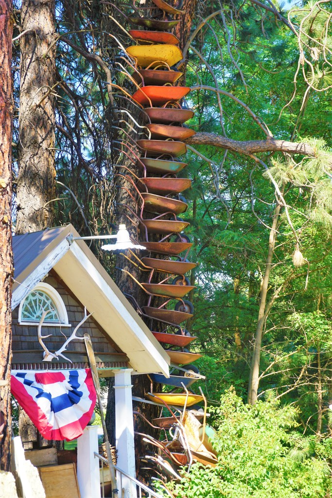
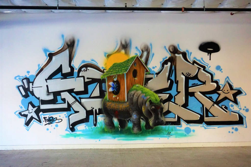
Street art, murals, and graffiti have given us the chance to feel so much more of a city; the ebb and flow of urban humanity expressed through a few cans of spray paint and the artist’s mind’s eye. We found the angst of the populous at Austin’s Hope Outdoor Gallery. We found Tucumcari’s addiction to heritage, and rage expressed at the George Floyd memorial in Minneapolis. We found Phoenix trying to hide its street art away by “allowing” free artistic statement all along a single back alley in an upscale hipster neighborhood. We found wonderous gonzo works in Las Vegas’ art district. Every piece is an artist’s interpretative expression and impression of a City in a particular place in our Country at a particular point in that City’s timeline of life.
We do admire the classics found in sticks and bricks museums – the beauty, exquisite technique, and timelessness of the artist’s work impresses. But as with our street art friends, the subject, color and brush stroke used, and emotive power of the finished work remains an expression of a point in time in the artist’s world view; a motivation driving the artist’s creativity – that in turn is driven by how what is around him or her influences the work produced.
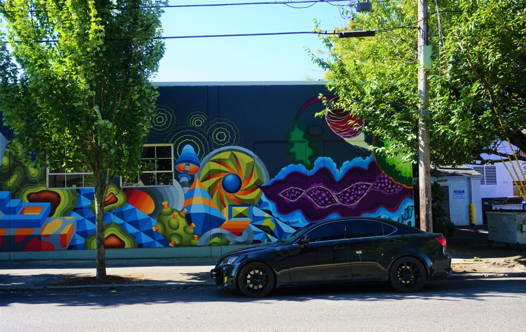
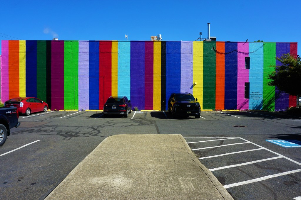
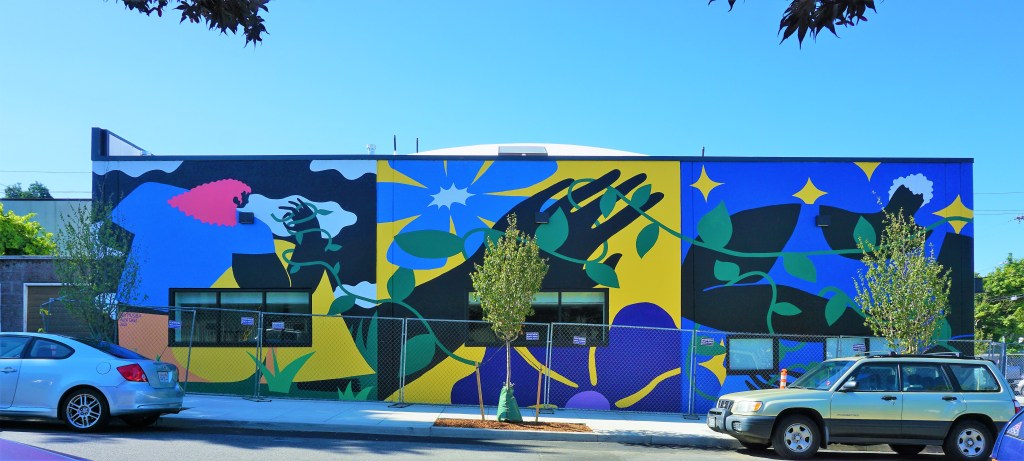
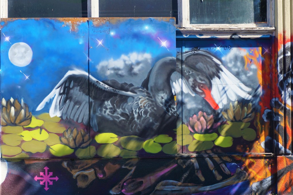
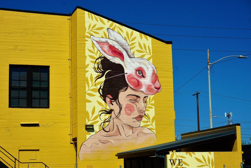
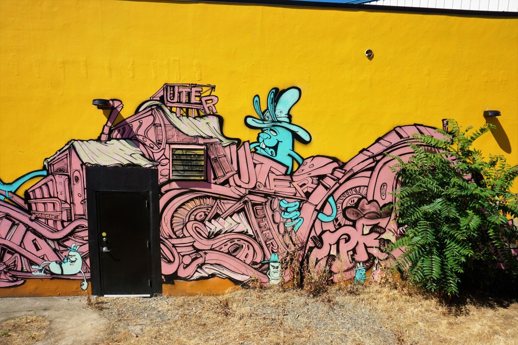
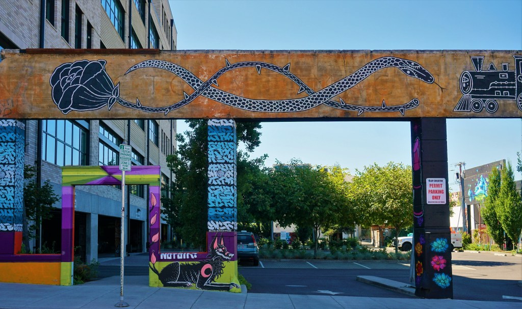
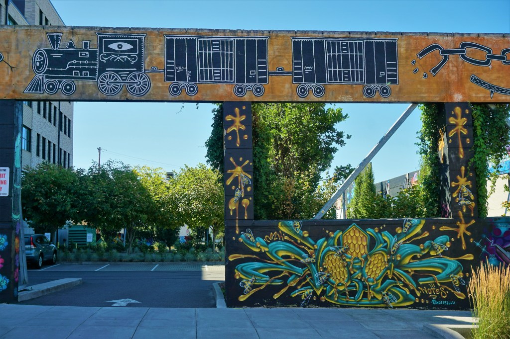
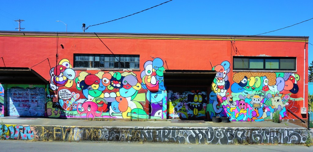
On a bright sunny day in Portland we found a downtown parking space central to our mission, unloaded our bikes, strapped on our helmets and started peddling ready to see what Portland’s contribution would be to our expanding collection of photographs – we were off to find a sampling of the murals of this City of neighborhoods, Portlandia citizens, parks, homeless encampments, industry, manufacturing, more homeless encampments, waterways and bridges, sporting teams, shopping, feasting and nightclubbing!
Some 10 miles or so later we felt we had covered the heart of Portland’s downtown and its street art…
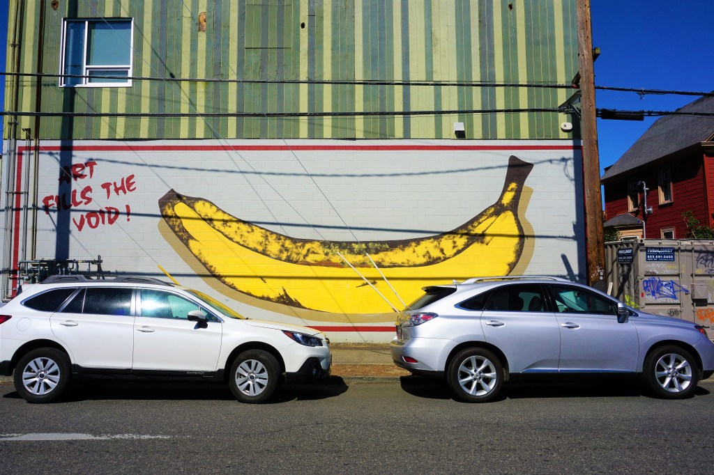
That’s “Art Fills The Voiid”Really Like The Owl
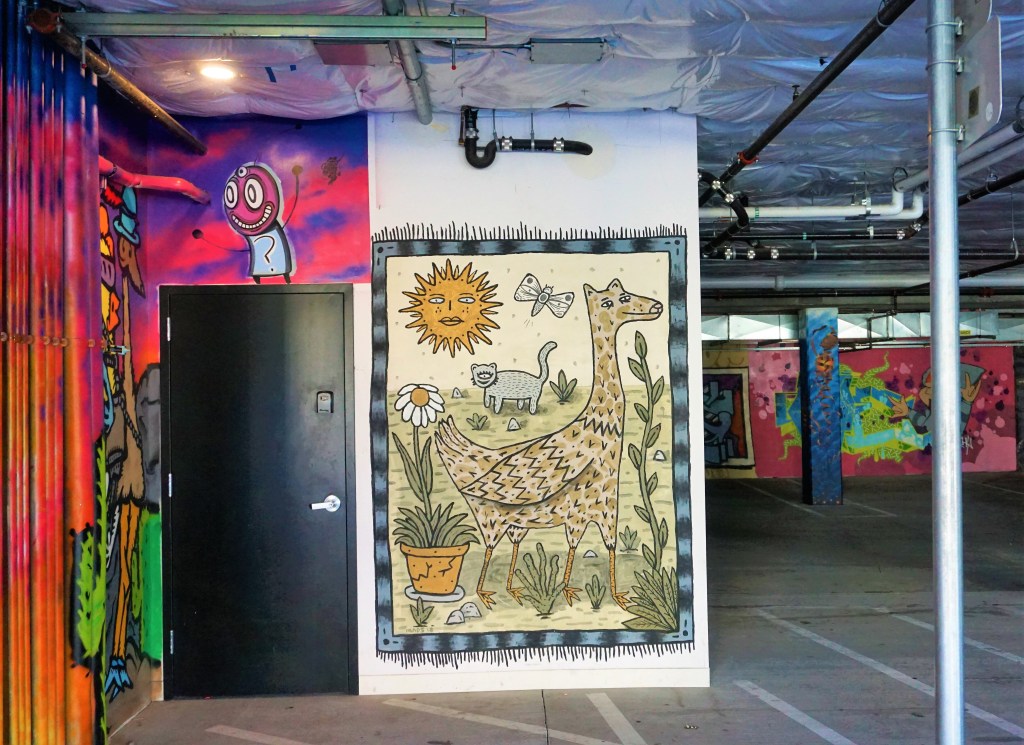
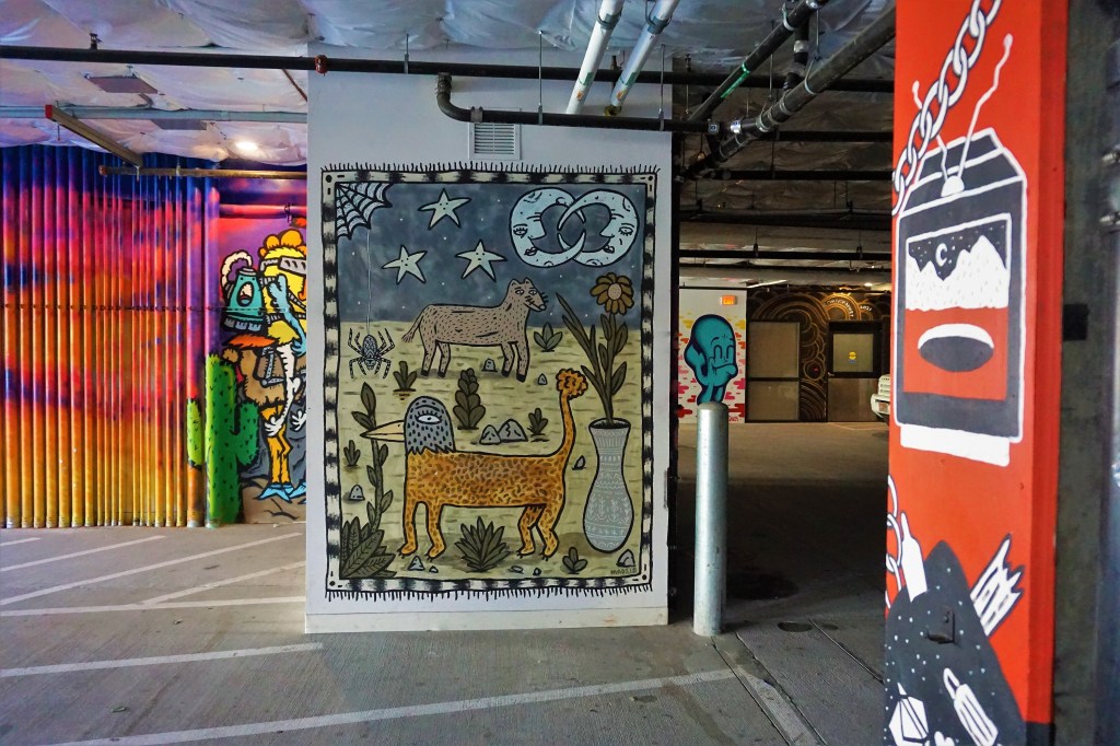
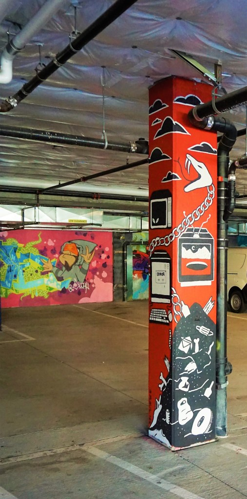
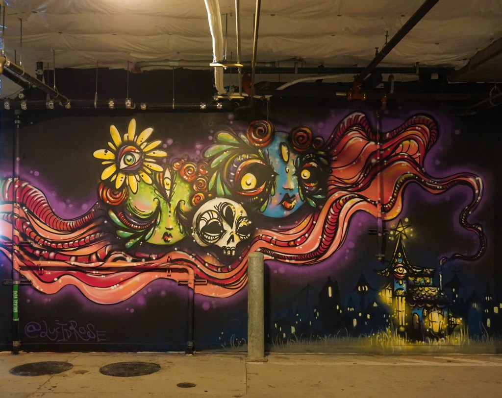
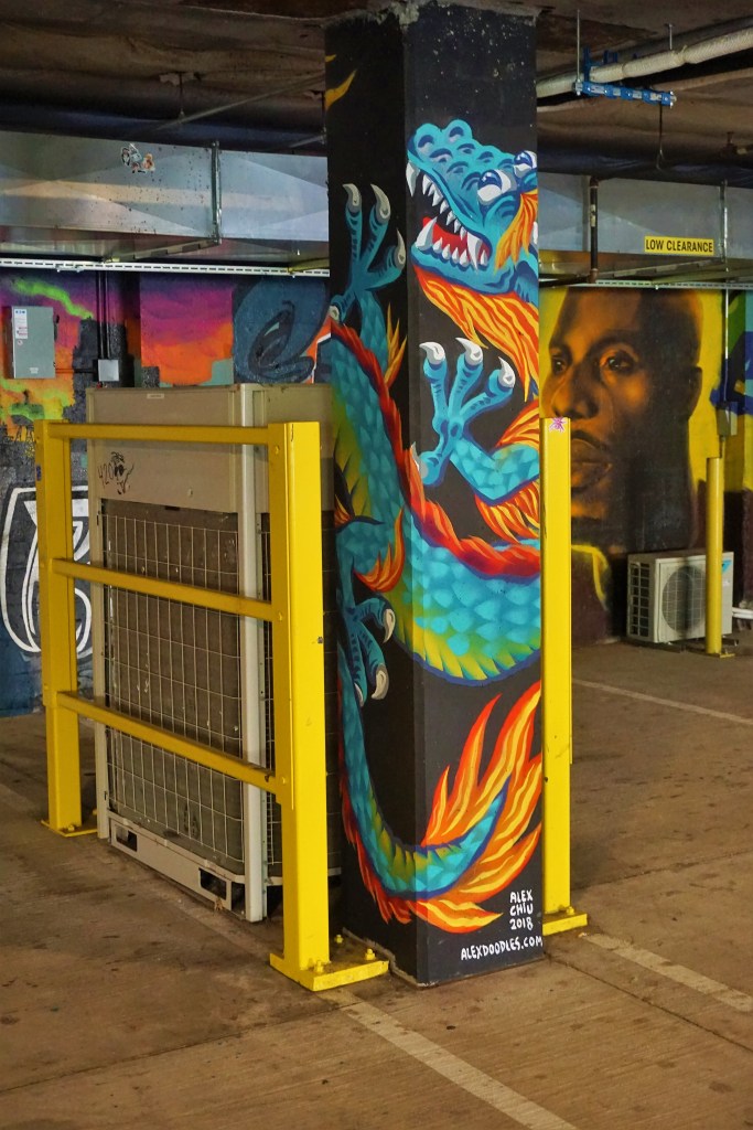
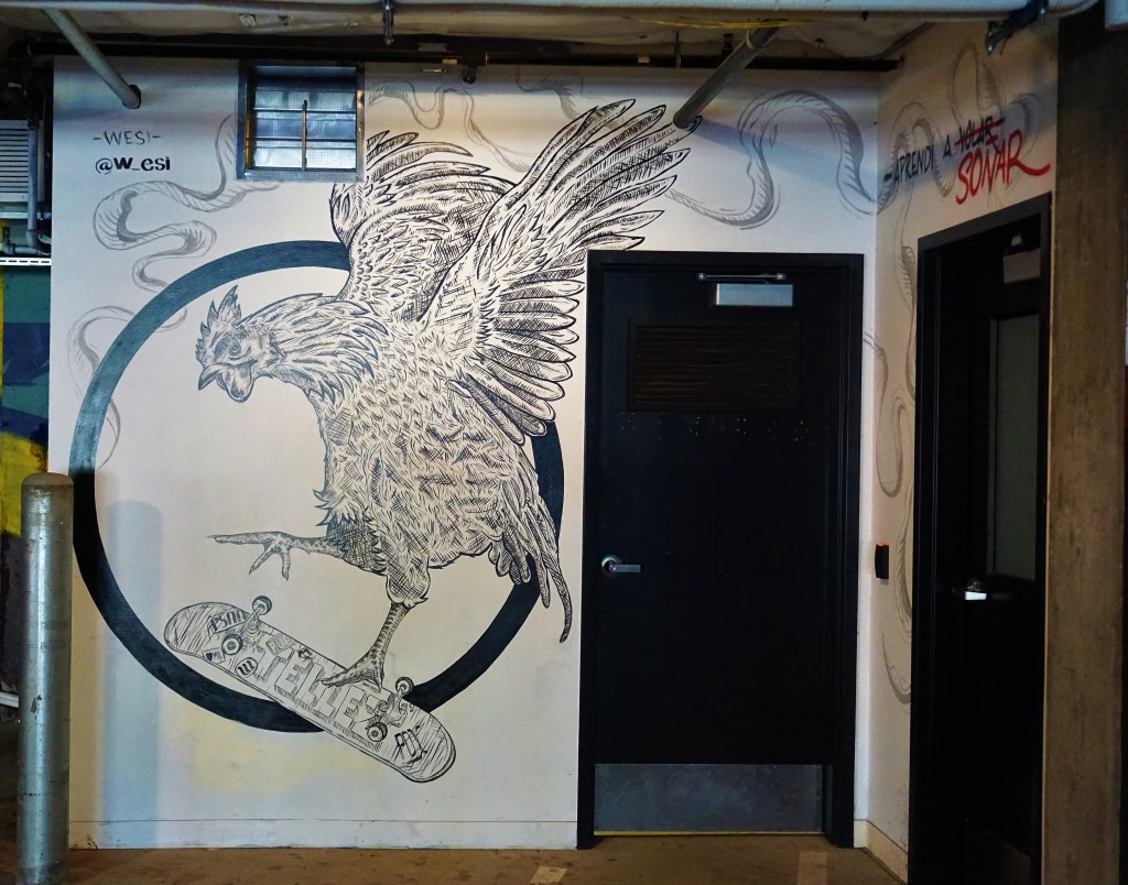
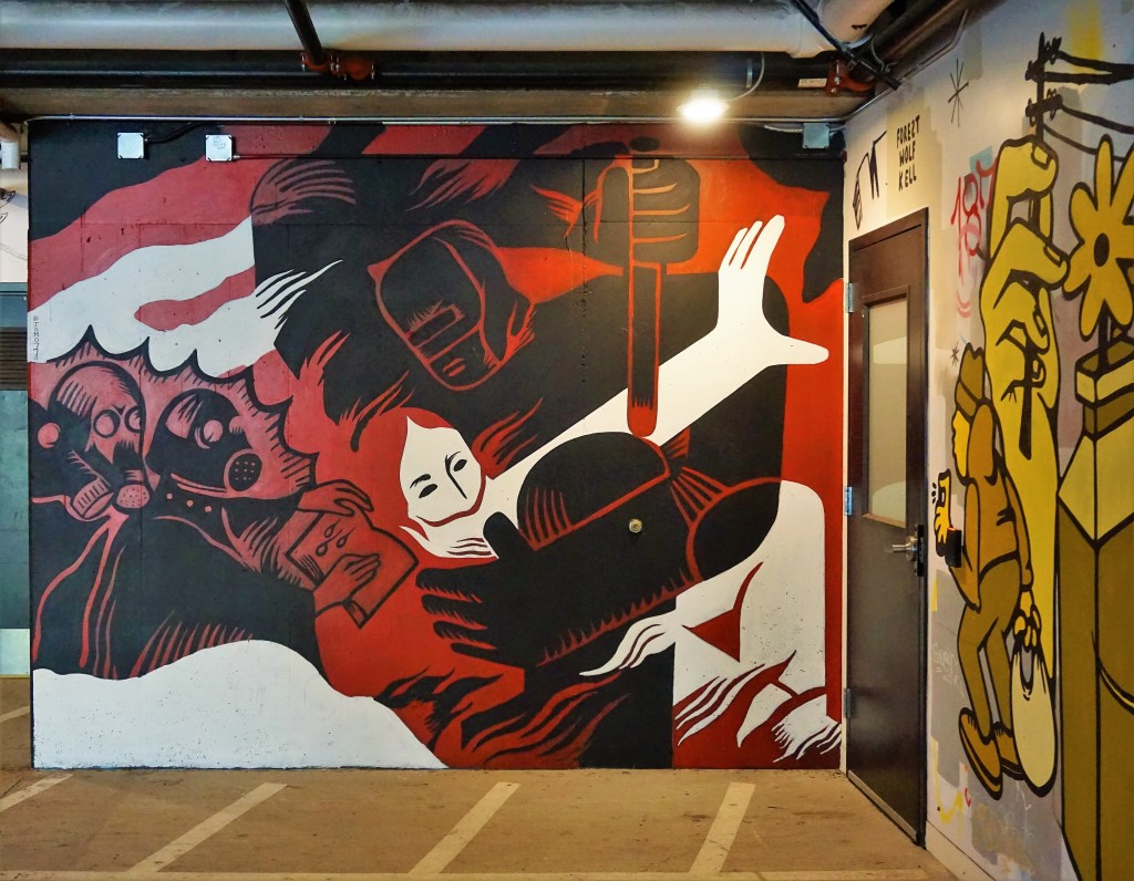
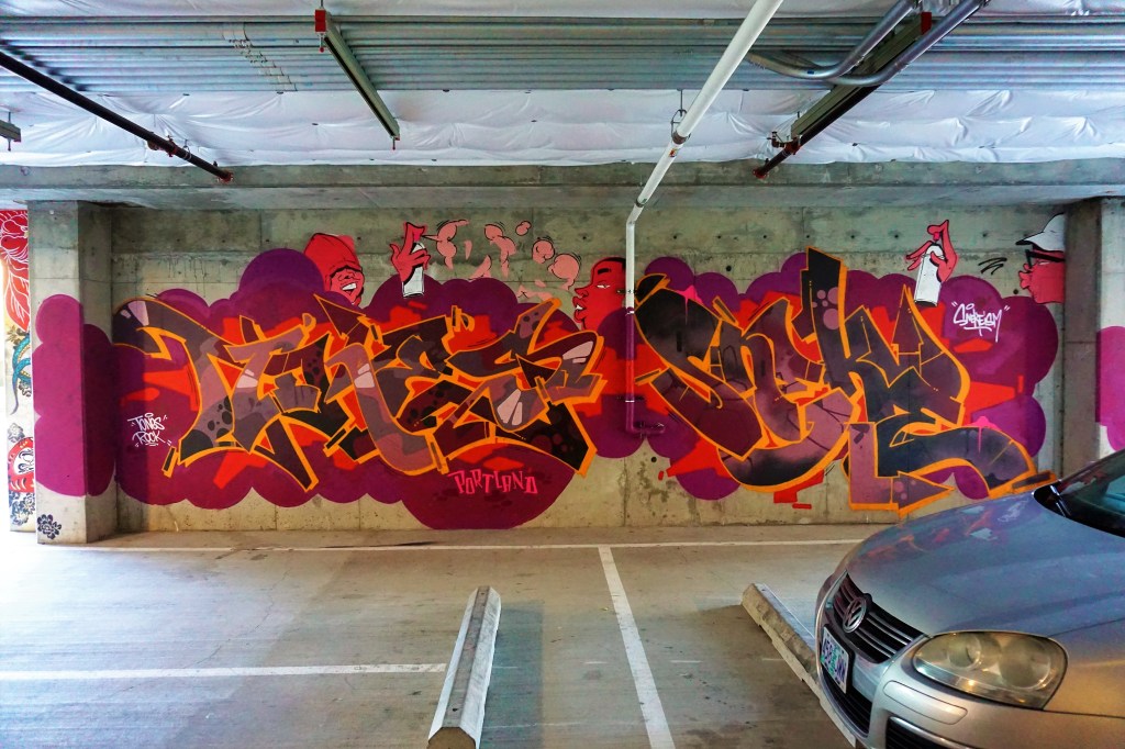
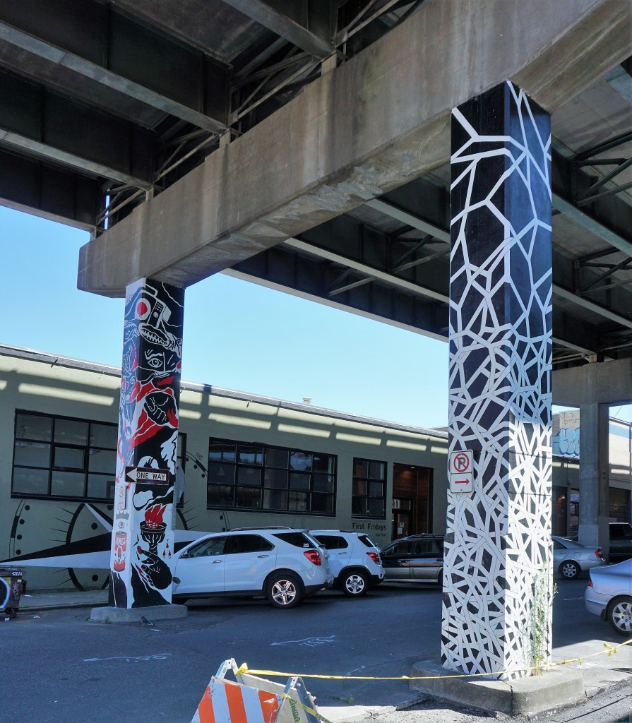
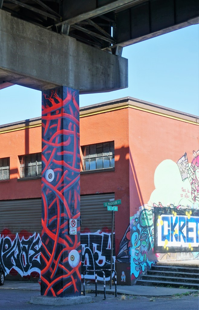
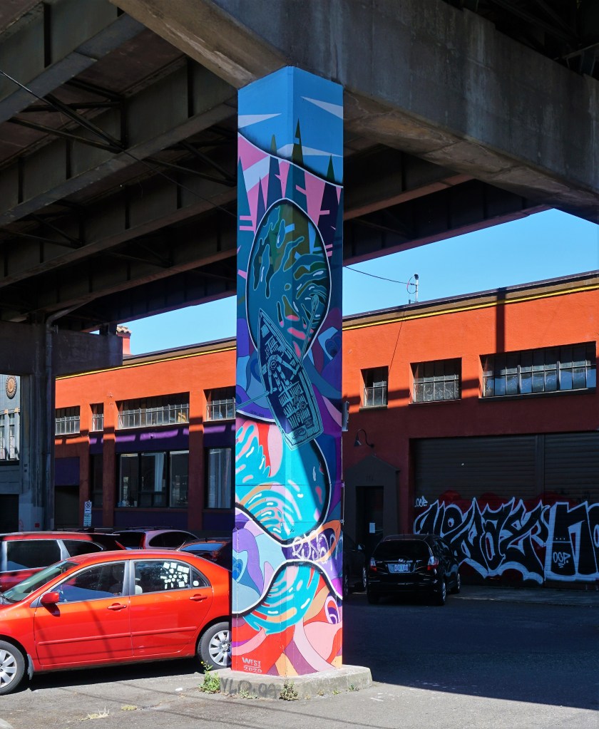
About a mile or so from this last piece we stumbled across outdoor and indoor parking lots in service to a single office building. The richness of the artists’ work was astounding; a fabulous find in this urban setting.
Interpretation?Yup – A Homeless Encampment In The ForegroundThis Building Is Brian’s FavoriteInterpretation?
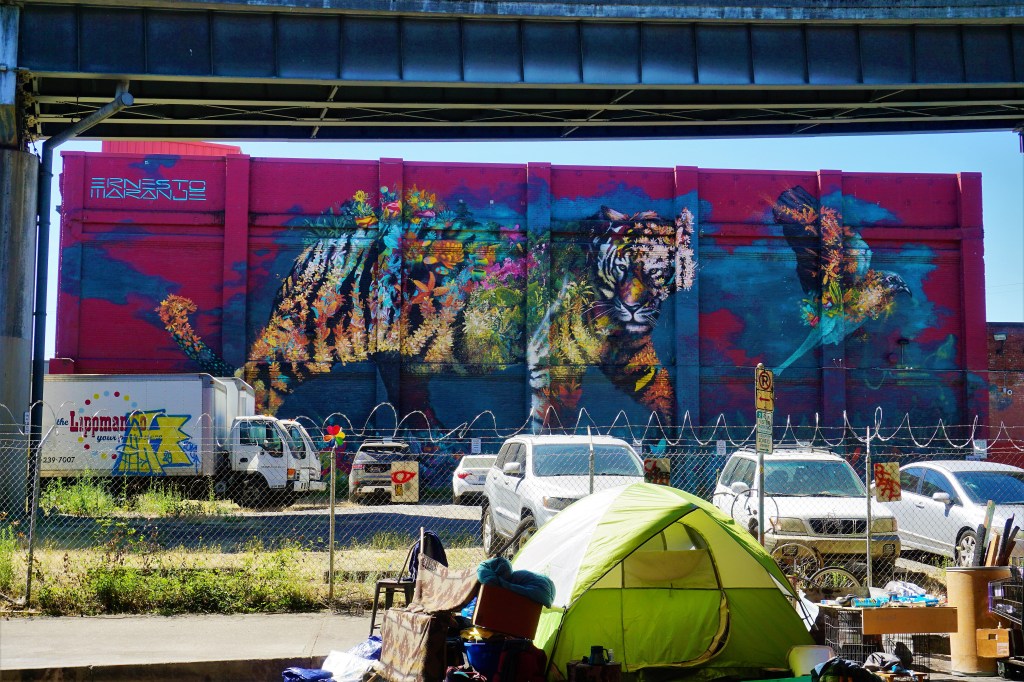
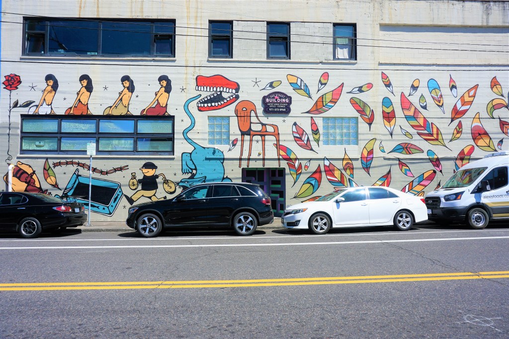
Riding our bikes in pursuit of artistic creations gave us a chance to experience and (perhaps) absorb the energy of the neighborhoods – upscale blending into a warehouse district blending into the edge of a “tent town” of the homeless blends into retail blends into apartments and houses and condos.
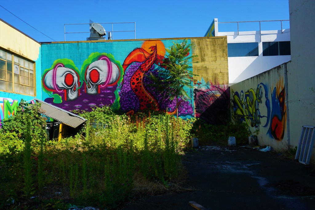
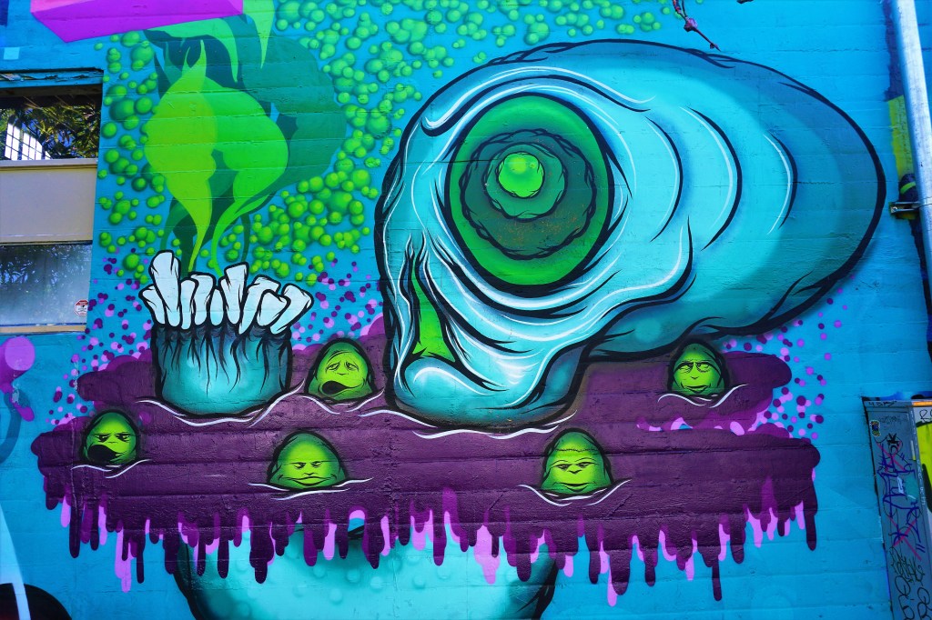
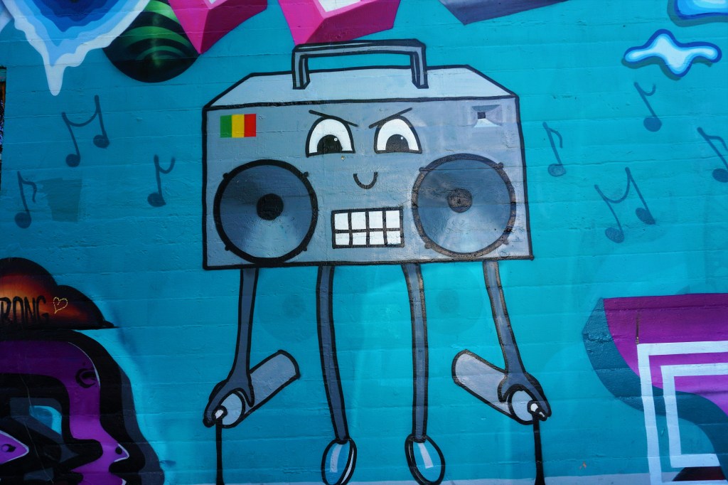
Imagine a dozen or so neighborhoods contributing to Portland’s outdoor museum of street art, murals, and graffiti, and realize that Barbara and Brian touched only 1. Downtown seems to be eclectic enough – vibrant colors, creatures formed by the imagination and fantasy, a world of cartoons, a hint of protest and a little whimsy, and a good smattering of reality.
Just what one would expect to see on a sunny day in a typical city. Got a favorite?
Barbara and Brian
“It’s not what you look at that matters, it’s what you see.“ – Henry David Thoreau
We had the chance to spend time visiting some of the treasures found in Portland – Voodoo Donuts, Hippo Hardware and Powell’s Book Store. But these sights were teasers thought up by our buddies at Atlas Obscura and The McGibbon Tour Guide Company…they failed to tell us that the weird side of Portland was a treasure in and of itself that would keep giving and giving and giving. And they failed to mention too that there were yet some beautiful locations to explore.
Andy and Bax “opened it’s doors in 1945 just after the end of World War II under the original name of “Grand – Hawthorne Surplus” selling wartime surplus, guns, ammo, tarps, rubber life rafts and just about anything one could think of. “In 1956 they began converting old military rubber rafts into white water boats, and during the seventies and eighties helped build the white water rafting scene in the Pacific Northwest.” Today Andy and Bax continues to bring new and used military, white water rafting and camping gear to the greater Portland area (and so tastefully displayed as well!).
Guess a quick donut stop was necessary! Delicious Donuts were indeed delicious, but Voodoo Donut remained a consensus #1 in our hearts and minds and in our bellies. The owner of Delicious Donuts has had a brilliant idea taking left-over day-old donuts and making donut bread pudding – Brian certainly thought it was a great product and most tasty.
Portland is home to Mill Ends Park, which at 452 square inches is thought to be the world’s smallest park and is rumored to be home to Portland’s leprechaun clan. Our search for The Park was for nought – it had been removed for road repairs – certainly most disappointing. However, on 01/22/2022 Mill Ends Park was re-dedicated. This picture was taken by Mick Hangland-Skill/Portland Parks & Recreation at the re-dedication.
Made by Oregonian sculptor Keith Jellum the whimsical statue of an 11-foot salmon swimming through a seafood restaurant can be ironically found on – you guessed it Salmon Street!
Matt Groening is one of Portland’s most famous citizens, and a short distance from Salmon Street he had etched a likeness of Bart Simpson into the concrete near one of the City’s high schools. Due to the construction of a new high school across the street, the etching has been “permanently” removed to a place unknown. Cowabunga!
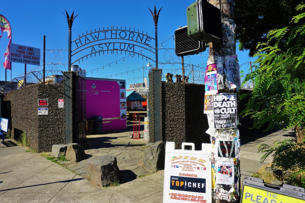
Like Austin, Texas, Portland abounds with food trucks.
Now Home To A Courtyard Of 20 Food Trucks, Hawthorne Asylum Functioned As A Hospital For The Insane From 1862-1881
Annually over 3.5 million people visit the City’s 410-acre Washington Park. It is home to the Oregon Zoo, World Forestry Center, Portland Children’s Museum, Hoyt Arboretum, International Rose Test Garden, and the Portland Japanese Garden. We had the good fortune to visit when the Rose Test Garden was in full bloom. The variety and depth of color was astounding…
Fuchsia
The McGibbon Tour Guide Company has a special (familial) connection to the Japanese outdoor supplier Snow Peak… their son, Jason, is a vice-president with the company so a visit to his “home” Portland store was a must. Founded in 1958, Snow Peak is a company engaged in the development, manufacture and sale of outdoor-style goods, mainly providing high-end camping supplies and climbing gear, as well as apparel and urban outdoor products, such as garden furniture. All of their outdoor products carry a life-time guarantee!
The Freakybuttrue Peculiarium and Museum is an oddities museum, art gallery, ice cream parlor and gift shop all rolled into one awesome destination. They pride themselves on helping to keep Portland weird.
Vampire Hunting KitCome Visit Soon!
Leaving the City for the time-being we headed east and found a short hike to the top of Beacon Rock that afforded another view of the spectacular Columbia River Gorge.
Did you know how much Barbara likes apple butter? Nah-neither did Brian until we ran across The Apple Valley Country Store and walked away with a couple of jars of the stuff. Not sure the first jar of apple butter lasted a week. Yeah- it was that good.
And as long as we were in the neighborhood, and of course it was happy hour somewhere, it seemed that a stop at the Wy’east Vineyard was necessary. If you’re ever in the neighborhood or bump into the vineyard’s label pick up a bottle or 2 or 3 of a very fine syrah.
The Dalles is 80 miles or so east of the metropolitan area, and is the largest city along the Oregon side of the Columbia River outside of Portland. The population is near about 16,000 souls, but the downtown maintains that small town feel.,,
Molly Hatchet? Canned Heat?
But why were we in The Dalles? The National Neon Sign Museum! It is found inside a restored Elks Lodge in downtown The Dalles, and presents a comprehensive history of light and signs. The project is headed up byDavid Benko, Rocket City Neon, Camas, WA, who has collected more than 10,000 neon signs and related items including catalogs, books, photos, salesman samples and neon-making equipment.
The upstairs floating ballroom is surrounded by a recreated mid-century setup of a downtown area complete with storefronts, historical signage, and window displays.
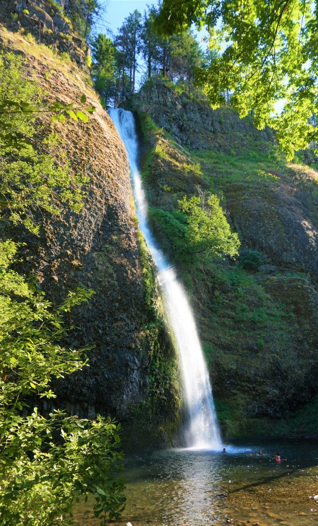
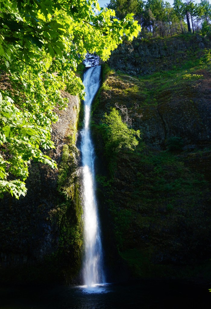
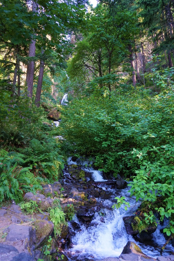
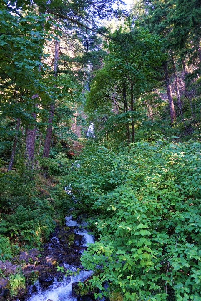
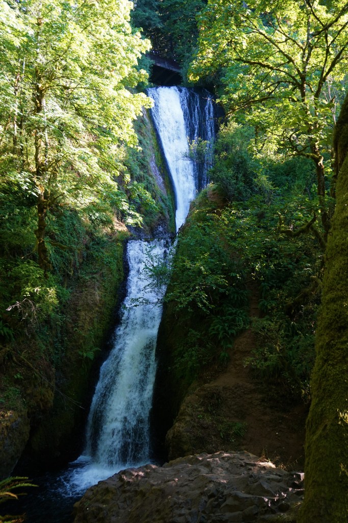
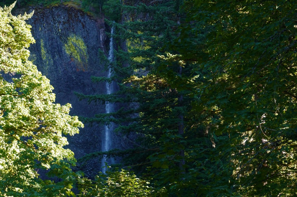
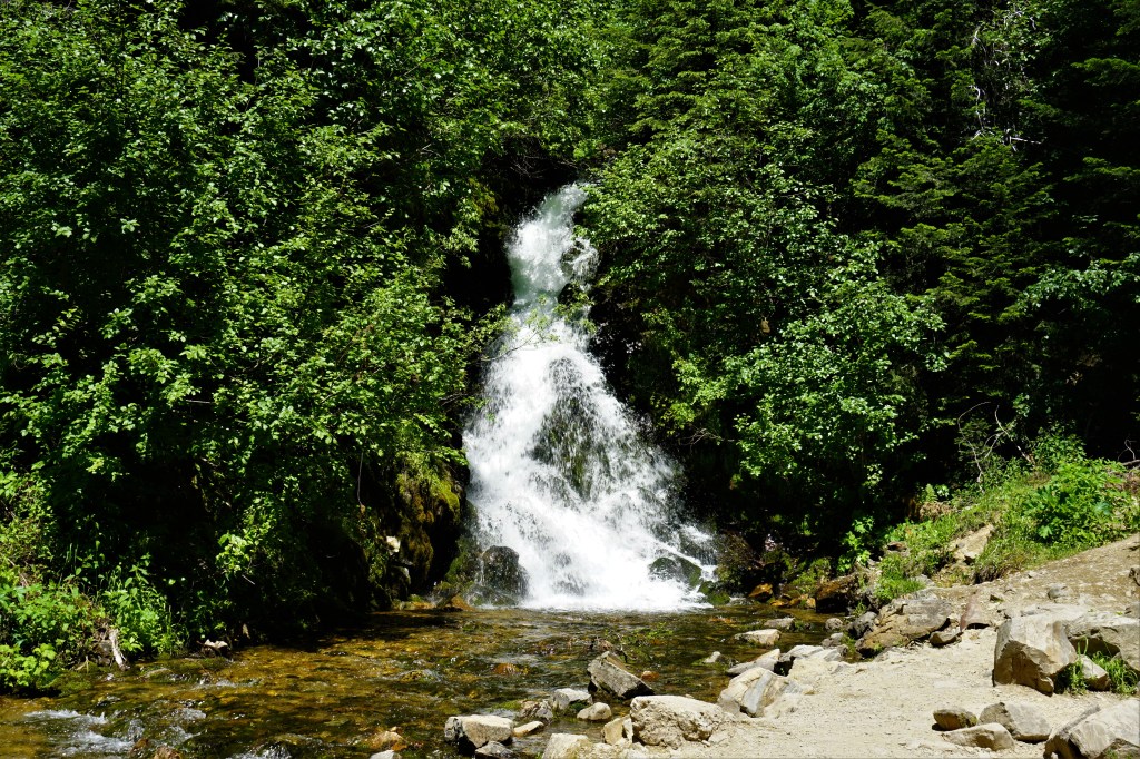
Barbara had done extensive homework about the number and location of Oregon’s waterfalls. She warned Brian that he might just get tired of the (with apologies to Chris Berman) stumbling, bumbling, tumbling cascading water. On a westbound trip along the Columbia River Highway, and on the way back from The Dalles there are 5 waterfalls easily visited. We had already spent time at Multnomah Falls…
A little of this, a little of that, unusual spots and beautiful scenery. The Portland area and Columbia River Gorge are generous in offering a seemingly unlimited amount of perfectly wonderful adventures. Sure, there may be a major problem with a 6-8 month (really!) rainy season that begins during the fall and ceases its daily watering of city and countryside alike sometime in June or so, but here we are in July and have fallen in serious like with this part of the world.
More to come!
Barbara and Brian
“It’s not what you look at that matters, it’s what you see.“ – Henry David Thoreau
We’ve had a few necessary repairs along this journey started so long ago. Some repairs were caused by human error, some the need to replace a gasket or filter or worn water line, and some repairs necessary due to the simple fact that bumping along down the road over so many miles will occasionally cause something to become loose.
We returned from our first marvelous adventure in the Columbia River Gorge to no electricity coming into Aimee. Making a long story short, the transfer switch had tripped. A transfer switch acts as a super circuit breaker; for example, should there be a power surge that blows through our surge protector or should the temperature of a component exceed a safe level the transfer switch “trips” and stops the electrical current from entering our home and causing electrical damage to various essential components internal to Aimee and/or causing an electrical fire. A circuit breaker can be reset; a transfer switch has to be replaced. The recommended repair guy came out, replaced the transfer switch, and when the electrical system was tested or “stressed” by turning on the air conditioners it tripped again! By the way, it’s the hottest summer on record in the Portland area and it’s Friday. Can’t stay comfortably in the rig and the repair shop would close for the weekend…so…we drove Aimee to the repair guy’s shop, parked it for the weekend, grabbed clothes and toiletries for a few days and checked ourselves into a Hampton Inn close to our Troutdale campground. Come Monday the technician discovered that a heat sensor on the front air conditioner had come loose (bumping down the road, no doubt), and every time the unit turned on it registered extreme heat tripping the transfer switch. Once the sensor was secured back in its proper place and the transfer switch replaced, we were good to go.
Mount Hood is Oregon’s highest peak at 11,240 feet and is home to 12 named glaciers and snowfields. Although the last eruption was more than 1500 years ago, Mount Hood is considered a “potentially” active volcano – we’re not sure but that phrase probably means that Mount Hood is a dormant volcano, but “just in case” all bases are covered.
The “McGibbon Tour Guide Company” recommended a trip to Trillium Lake for a nice hike with spectacular views of Mount Hood…
Rosebay Willow or FireweedCheck Out The Shadow On The LeafBeautifulMeadow Cat’s Tail or Timothy Grass
Followed by a hike ON Mount Hood.
The Snowfields Permit Year ‘Round Skiing And Snowboarding
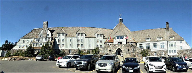
Timberline Lodge at Mount Hood has been serving vacationers, skiers and snowboarders since being built by the Works Progress Administration in 1931. There may also be something familiar about the Lodge to fans of the movie adaption of Stephen King’s “The Shining,” as many of the exterior scenes in the movie were shot right here!
Timberline Lodge At Mount Hood
Larch Mountain is an extinct volcano. There are 3 ways to ascend Larch Mountain in order to spend some time at the overlook known as Serrard Point. For the extremely fit hiker up to the challenge, there’s a 13.1 mile out and back trail that climbs 4396 feet (0.83mile) and passes through old-growth forest and past several waterfalls. The hike is considered very difficult and may take in excess of 8 hours. There is also a moderate hike of 3.7miles; the trailhead is found at Bridal Veil Falls and the change in elevation is 971 feet. Or, and oh so much simpler, the roadway permits a motor vehicle to ascend in a fraction of the time. Guess which we chose?
But why bother with Serrad Point at all?
From Serrad Point there are unrestricted views of Mount Hood, Mount Adams, Mount Jefferson, Mount Baker and Mount Saint Helens! Now, it’s quite some distance from here to there, but being able to have a sight line to most of the volcanos in the Cascade Volcanic Arc can only be done from Serrad Point.
Mount Saint Helens And Mount HoodMount Saint Helens, Mount Hood And Mount JeffersonMount BakerGotta Love This Little Visitor To Serrad PointLooking WestMount Saint Helens
Remember the 1985 movie The Goonies? Many of the neighborhood scenes in the movie were filmed in and around Astoria, Oregon. We never made it to that locale…actually the present owners of the properties are not very welcoming to tourists. But we did make it out to Canon Beach, home of the “famous” Haystack Rock. At the end of the movie “One-eyed Willie’s pirate ship The Inferno” sails by Haystack Rock on its way out to sea.
Canon Beach – Haystack Rock
Not too much to see in the tide pools around Haystack Rock. However, bird watchers with very powerful binoculars or cameras equipped with a strong telephoto lens claimed to see puffins on the Rock. The sea birds were not evident to the naked eye or with the telephoto lens on Brian’s camera.
Moseying on south to Hug Point gave us landlubbers quite a thrill. The tide pools provided wonderful sights of sea anemones and sea stars, and the skies offered up Brian’s favorite – pelicans in flight.
Dig The Reflection!Abundance Of Life Above And Below The Water Line Looking South Along The Oregon Coast
Hug Point provided some pretty nice sea caves and rock formations, too.
When roads were first built for the “horseless carriages” in the early 20th Century the roadway often left the solid foundation of rock, and drivers found themselves trying to skedaddle across the sand…far too often resulting in the vehicle sinking into the soft surface and needing a “tow.”
The Original Pacific Coast Highway – Leading Right Into The Sand!
“Damn Right!” Brian exclaimed when The “McGibbon Tour Guide Company” guide asked if he enjoyed corn dogs. Barbara’s not that much of a fan, but she’s been known to choke down a corn dog or 2 on occasion. Pronto Pup considers itself the original corn dog; however, their dogs are dipped in a pancake-like (rather than corn bread) batter mix as invented in Rockaway Beach, Oregon, and then fried. Was there a question that a stop at Pronto Pup was next on the agenda? Alas and alack the restaurant was closed…drat!
Just a little bit further south along the coast is Tilamook, home to the dairy co-op that manufactures cheese and ice cream, sour cream and yogurt, and which has expanded its products to include jerky and meat sticks. Following a factory tour which included samples of medium cheddar and cheddar flavored with black pepper (winner, winner, chicken dinner!), an ice cream cone was requisite. YUM!
Irony Is Everywhere – Note RV Sales And Service Sign
So much to see and do in this part of Oregon, and we’re just scratching the beginning of the possibilities. Or is it that we’re rookies in this part of the US, and we appreciate everything we experience? We hope you agree with us that it doesn’t matter much – there’s so much more to come!
Barbara and Brian
“It’s not what you look at that matters, it’s what you see.“ – Henry David Thoreau
Far more than once Barbara and Brian, on their journey started so long ago, have found or perhaps stumbled upon a place that is just simply a jewel; someplace that takes the breath away; someplace that impresses viscerally; someplace one wishes, amongst all the other places in our world, we could come back to again and again to further discover every nuance and be bedazzled over and over. Oregon’s Columbia River Gorge, Canon Beach and Hug Point, Mt Hood, amd Portland itself hit every note for us.
But unfortunately, the Oregon wildfires during the summer of 2021 affected our time in Eugene and stops further south negatively, and even made a visit to Crater Lake different than the usual and customary spectacular OMG experience.
Leaving Sequim we had a repeat white-knuckle journey south on Highway 101 along the eastern Olympic Peninsula connecting with Interstate 5 for a little more than 100 miles before entering Oregon and turning east on Interstate 84. We eagerly anticipated our time staying in Troutdale at the Sandy River RV Park – the Park all of 10 miles east of downtown Portland.
Jack and Chris McGibbon are friends we made at VDO 2 seasons ago, and we had stayed in touch since going our separate ways in January 2020. We had been planning on reconnecting in Troutdale last summer, but our cancelled trip pushed the time together to this year. They had lived in the Portland area for quite a number of years, and while now full-time RVers a good part of their summer has been spent at this park the last 4 summers since they have family nearby. We truly had quite a reunion, and we felt very fortunate that the “McGibbon Tour Guide Company” gave so much of themselves in order to make our stay so very special. Oh, the wonders we experienced during our 3-week stay! We are so eternally grateful to our dear friends.
Let’s get started…
The Columbia River Gorge is a canyon of the Columbia River. Glacial floods thousands of years ago carved this 1,200-mile-long river, which is the only sea-level passage to cross the Cascade Mountains. With cliffs rising as high as 4,000 feet, the Gorge acts as a funnel for North America’s fourth largest river, whose tributaries include the mighty Snake River. The canyon itself stretches for over eighty miles as the river winds westward through the Cascade Range, forming the boundary between the state of Washington to the north and Oregon to the south.
Vista House is a museum at Crown Point in Multnomah County, Oregon that serves as a memorial to Oregon pioneers and as a comfort station for travelers on the Historic Columbia River Highway. The site, situated on a rocky promontory, is 733 feet above the Columbia River on the south side of the Columbia River Gorge.
There are about a dozen waterfalls accessible from the Historic Columbia River Highway, and the 620-foot cascading Multnomah Falls is the first to greet visitors traveling from the west.
The Oregon Department of Fish and Wildlife built a first-class, fish-friendly sturgeon holding facility at Bonneville Hatchery next to the Columbia River near Cascade Locks that is now known as the Sturgeon Viewing and Interpretive Center. The Sturgeon Center is situated under a forest canopy and has a continuous flow of cool, fresh water. A paved path partway around the pond provides easy access to a viewing platform where people can get a bird’s eye view of this prehistoric creature that is believed to be unchanged from its development during the Jurassic Period 100-200 million years ago.
Hydrangea
Jack and Chris made sure we visited Hood River, a small town along “The Gorge”, 60 miles or so east of Portland where we found out that in this neck-of-the-woods, surfers looked to ideal wind conditions, not the height of the ocean’s waves to be able to “hang ten.” Not sure “hang ten” is a term applied to wind surfers but watching these athletes skim across the water standing on their board while holding onto what looked like a big kite was indeed thrilling. And yeah, the wind was strong and incessant.
We crossed over the Columbia River at Cascade Locks using the Bridge of the Gods, a cantilever bridge. Cantilevers are structures with horizontal spans that are supported at one end with a vertical structure. The bridge’s name comes from a Native American legend: “millennia ago ‘the gods’ caused a boulder to fall into the river creating a natural bridge that permitted people to cross over the waters.”
Bonneville DamColumbia River – Washington Side, Looking East
Guess we must have worked up an appetite for donuts chasing along the Historic Columbia River Highway. No visit to Portland is complete without a trip to experience Voodoo Doughnut, at least to Brian. As Barbara was putting together the list of “must do’s,” and there is a lot yet to come, Brian kept insisting a visit to this iconic donut shop was essential. So, here we are.
Featured on the Food Network for its unusual donut creations, couples can purchase a wedding package at any of their 11 locations. The wedding package which starts at $300 includes a ceremony, doughnuts, and coffee. The bride and groom can have doughnuts decorated to order, and a shower of sprinkles rather than confetti to congratulate the newlyweds once they’re officially married. There is even a giant heart-shaped doughnut, engraved to order with frosting, which is pretty much a must for any ceremony.
The maple bacon bars and pastry cream filled voodoo doll donut are truly wonderful, and don’t you dare count calories!
Flagship Location
This may get repeated several times across several blogs about our time in the Portland area, but one of the advantages of hanging out with “locals” is that they know more unusual places than have been reported by Atlas Obscura. The “McGibbon Tour Guide Company” never fails. We give you Hippo Hardware…
Hippo Hardware was officially established in 1976 after the founders Steven Miller and Stephen Oppenheim “decided to turn a life of swashbuckling adventures into a second life of swashbuckling adventures.” Fortunately, Steven Miller was at the store during our walk about. He is a fast-talking, quick-witted, conservative supporter of social organizations, gun carrying Viet Nam vet who told us that the store was named in honor of a female friend from high school who was the only person at the airport to greet Steven on his return from ‘Nam. She may have been a larger woman, but that simple act of love and friendship (when Vets returning from service during that era were shunned, insulted and ridiculed) earned her a forever place in Portland’s history.
Hippo Hardware has three glorious floors and 30,000 sq feet of building salvage to explore. It is an eclectic place specializing in hardware, lighting, architecture and plumbing from 1860-1960. They offer “assorted collectibles, trinkets, whatnots, and whoziwhatsits depending on what is brought in.” If you’re looking for the straightforward and/or esoteric in hardware and building supplies, there’s a good chance Hippo Hardware can fill your order. For example: “if you want to replace your doorbell with a Victorian model that works with a crank, or stop your sink with a 100-year-old industrial drain basket, or light your room with iron sconces pulled from a Pullman sleeping car” it’s no problem – the question is how many you’d like!
Hippo Hardware provides employment for the homeless. Hippo Hardware provides food for the homeless, who are also welcome to use its bathrooms. And 10 to 15 people sleep each night on a covered area of sidewalk outside the store.
Quite impressive overall…
Powell’s Bookstore claims to be the largest independent new and used bookstore in the world and occupies a full city block in downtown Portland – over 68,000 square feet – and about 1.6 acres of retail floor space. CNN rates it one of the “coolest” bookstores in the world.
Nice start, no? So, sit back and enjoy the next several blogs, presented in chronological order, all about our time in and around the parts of Oregon we fell in love with – a part of the country unique in its diversity, generosity of spirit, wonderous in its sights from mountains to rivers and oceans, and (when not raining) perhaps should be kept a bit of a secret since we wouldn’t want to have such a good thing spoiled!
Barbara and Brian
“It’s not what you look at that matters, it’s what you see.“ – Henry David Thoreau
We had several other planned adventures from our home in Sequim, the primary of which was an all-day whale watch cruise to Friday Harbor in the San Juan Islands.
Along the way some unplanned stops made for fine adventures…
Traveling back to Sequim from visiting the Hoh Rain Forest we stumbled through the small town of Forks, Washington. Curiously enough, parts of the Twilight movie franchise were filmed here. Brian probably should have taken a couple of photographs of the cabins and surrounding woods, but there is the novelty of discovering the unexpected after all.
The Treaty Between Vampires And Werewolves
Port Angeles is just about 20 miles west of Sequim, and we passed through a few times when heading up to Hurricane Ridge, out to the beaches and over to the Hoh Rain Forest. Heading home after one of our journeys, we stopped for a cup of coffee only to find that the city was reopening (after the covid shutdown) and celebrating the return of live music to its amphitheater.
Sculpture – Port Angeles, Washington
We took a seat with a hundred or so of our “new closest friends” and gave a listen to the tunes of Ant Bath. The band calls it’s musical genre underground garage surf. Not sure what that means, but it’s sorta kinda like combining acid jazz with arcane rock while on ‘ludes. Clear?
Bainbridge Island is a city of 23,000 on the Puget Sound and from there it’s a short ferry ride to Seattle. The Island is home to amazing boutiques and restaurants, a wonderful harbor, a decent walking trail and some amazing flowers.
Rose Campion or Bloody William or Dusty MillerAmazing Growth Of FernsHydrangeaPainting Or Photograph? Garden Dahlia
A floating bridge is made of concrete and steel that is “built on a sheltered water-crossing where it is not considered economically feasible to suspend a bridge from anchored piers. Such bridges can require a section that is elevated, or can be raised or removed, to allow waterborne traffic to pass.” There are 5 floating bridges 4 of which connect Seattle to various points west and across Lake Washington. The 5th floating bridge connects Bainbridge Island to the Olympic Peninsula.
The San Juan Islands are an archipelago between the US State of Washington and Vancouver Island, Bristish Columbia, Canada. The archipelago is made up of hundreds of islands, some no bigger than a rowboat and many that disappear if the tide gets too high. Many of the small and medium-sized islands are privately owned.
San Juan, Orcas, and Lopez Island are the most popular locations for tourists; campgrounds are available on these islands for the more adventurous visitors. San Juan Island is considered to be the jewel of the archipelago, and the City of Friday Harbor is the destination for many of the day cruises from Port Townsend as well as other coast cities within reach such as Fidalgo Island and the town of Anacortes. Our cruise to and from Port Townsend would cover 62.8 nautical miles.
Remember Carl Sandberg? One of his most famous poems goes like this: “the fog comes on little cat feet. It sits looking over harbor and city on silent haunches and then moves on.” The fog was dense and covering harbor and city as we were prepping for and at the beginning our cruise.
Once we were out of the Port Townsend harbor would the fog surround us? Probably! We began early in the day, and the fog in the morning is as ubiquitous as moss in a rain forest. Would the fog burn off for the afternoon cruise back to port? Definitely! Would we see sea lions and seals during our cruise? Absolutely! Would we see whales during our cruise? Maybe! Would we see bald eagles during the cruise? Bald Eagles out in the Pacific Ocean?
Leaving The Safety Of Port Townsend – This Is A Favorite Photograph Of Brian’sBald Eagle Standing Guard!Check Out The Sea Plane LandingFox Glove
It was a wonderful trip to Friday Harbor, San Juan Island. The fog remained with us for about two-thirds of the outbound trip, the sound of our foghorn adding to the mystery of the vast, dark, deep, and dangerous ocean. The fog burned off and the temperatures warmed as we approached Friday Harbor. An easy walk and we found ourselves checking out the boutiques along main street. After purchasing some sandalwood soap, we ate a quick lunch at a restaurant overlooking the harbor and made our way back to our boat for our return voyage.
Little did we expect that about a half hour out of port we would find a pod of 4 orca feeding. The naturalist on board explained that the size of the dorsal fin and its particular white marking was the best way to identify individual orca.
See The Spray or “The Blow” Over Two Dorsal Fins?
And what a joy to once again see Mount Rainier during our journey across the Strait of Juan de Fuca back to Port Townsend.
We got out on the water and finally got to see some sea life! On land we found a couple of pretty cool places to explore. Thinking about these as well as our adventures in Olympic National Park and what we found was someplace that would take a lifetime to really truly explore.
It’s a short 84 miles from Shelton to Sequim, but the RV GPS figures that by using the most direct route it’ll take two and a half hours. Two and a half hours? Well, the route is along the coast and follows the Hood Canal northward on US Highway 101 for 70 miles or so before the roadway takes a gradual sweeping semi-circular turn to the west for the remainder of the trip. But two and a half hours? The roadway north is a white-knuckle forested, twisty, narrow jaunt with no shoulders, substantial drop offs, blind turns, pull-outs for slower vehicles (Aimee perhaps?), and occasional small towns all of which slowed the speed in our motorhome down to a reasonable crawl. Once we could turn westward, we were able to travel at a decent 55 miles per hour or so. Well yeah, two and a half hours was just about right.
Roosevelt Elk Welcome Here!
Sequim (the e is silent) is a town of 7,500 in the northern-most part of the Olympic Peninsula. Sequim Bay is to the east of town and is part of the larger Strait of Juan de Fuca which separates the US and Canada. The town’s notoriety is tow-fold: acres and acres of lilac fields abound, and a herd of 100 Roosevelt Elk roam the area freely. The elk have been tagged with a transmitter that “sets-off” a series of red lights on Highway 101 in warning of the herd approaching the roadway. There were no elk sightings during our stay, but the lavender was intoxicating.
One Of Sequim’s Lavendar FieldsSequim Bay “Yacht” ClubBeautiful Sequim Bay
There are many campgrounds all along the northern-most part of the Olympic Peninsula which stretches 160 miles from Port Townsend on the east to Neah Bay on the west and then 160 miles south to Aberdeen along the west coast. Some part of Olympic National Park is easily accessible from any campground along this route.
However, it takes a bit of time to get from here to there.
So why did we stay in Sequim? It’s 30 – 45 minutes to the larger cities of Port Townsend or Port Angeles. When visiting Olympic National Park it’s a little more than an hour to Lake Crescent or Marymere Falls, an hour and forty minutes to Hurricane Ridge, an hour and fifty minutes to the beaches, and two and a half hours to the Hoh Rain Forest. Perhaps it was not quite a centrally located home base from which to complete our plan for experiencing The Park, but then again perhaps it was just perfect…
Olympic National Park is the 4th most visited of our National Parks with over 4 million visitors annually. The Park encompasses 1442 square miles, 95% of which is designated as wilderness, and within The Park there are over 3,000 miles of rivers and streams fed by over 60 named glaciers. Mount Olympus at nearly 8,000 feet is its highest peak. The Hoh Rain Forest receives between 12 to 14 FEET of precipitation each year and is the only temperate rain forest in the contiguous Unites States. The coastline features 65 miles of beaches, sea stacks, and rocks. We found ourselves wanting to explore each of the 4 regions found within Olympic National Park – pacific coastal, forest, rain forest, and mountains – as well as the Park’s 3 ecosystems: subalpine forest and wildflower meadow, temperate forest, and the rugged pacific coast. We’re pretty sure that nowhere else in our country could we find such variety of Mother Natures’ creations in one place and all of it ready for endless exploring.
As with so many of the places we have visited we mapped out our first experiences highlighting the “not to be missed” attractions. For Olympic National Park those included Hurricane Ridge, Lake Crescent and Marymere Falls; Ruby, Rialto and Third Beach, and the Hoh Rain Forest.
Even though we had visited the Pacific Coast during our stay in Shelton, there was still hope that we could view migrating whales and resident orcas, puffins, and sea otters- from Ruby, Rialto and/or Third Beach, the National Park’s more famous beaches. We were disappointed that we did not view any sea life, but we did have a wonderful hike through the coastal forest and great views of sea stacks and the Pacific Ocean. And the bonus of differing weather conditions made for some wonderful pictures.
From Ruby BeachRialto Beach ViewsHike To Third Beach Macro Photograph – Top Of A Fallen LogThird Beach
We also stopped by Pacific State Park in the hopes of catching a view of sea life…at least the gulls and a lone pelican were willing to pose for a picture.
Lake Crescent is a stunning 624-feet deep glacier-carved lake outlined by rolling hills and a forested mountain range…amazingly blue waters – beautiful!
It was an easy hike through the rainforest to Marymere Falls at Lake Crescent…
Moss-Covered Trees – Ubiquitous Sight In The Olympic National ForestMarymere Falls
Carving its way from Mount Olympus towards the Pacific Coast Beaches, the Hoh River winds its way through the temperate rain forest that bears its name. The Hoh Rain Forest has a lush, green canopy of both coniferous and deciduous tree species including Sitka Spruce, Red Cedar, Big Leaf Maple and Douglas Fir; mosses and ferns blanket its surfaces. The rain forest averages 140 inches (3.55 meters; just under 12 feet) of precipitation each year; most of it falling from late fall through early spring. Hiking trails are well marked, the shortest of which is 0.8 miles, the longest a 34-mile multi-day round trip. The Hall of Mosses trail afforded us a terrific introduction to the uniqueness of The Hoh Rain Forest.
Macro Photograph – Top Of A Fallen LogSomehow Seeing A Banana Slug In A Rain Forest Was Not A Surprise
Climbing from 65 feet above sea level upwards to 5,242 feet Hurricane Ridge affords the most spectacular views in Olympic National Park. The roadway winds its way from the Port Angeles Visitors Center to the Visitors Center at the Summit – turn-outs and parking lots along the way gave us ever more awesome views.
From the Visitors Center several hiking trails are available. Head out in one direction and you can see across the Strait of Juan de Fuca onto the shores of Victoria, Vancouver Island, British Columbia, Canada.
Pink Mountain HeathCow Parsnip
But the most stunning vistas were from the higher elevation vantage points facing east and southeast…we easily imagined ourselves in the Swiss Alps.
We Made Some New Friends Along The WayGettin’ The Razzberries From Bambi!Mount Olympus – The Tallest and Most Prominent Mountain in the Olympic MountainsLook At All Those Glaciers!
What a magnificent place in our Country! Barbara fell in love with the mountain views from Hurrican Ridge, and Brian was blown away by Mother Nature on display in Olympic National Park.
Barbara and Brian
“It’s not what you look at that matters, it’s what you see.“ – Henry David Thoreau
We’ve been able to view the majesty of Mount Ranier for the past couple of days. A clear view of the summit has been our companion since we traveled over Snoqualmie Pass, and all the way into Seattle. It has stayed with us during our journey south through Olympia and ultimately north into Shelton. We could see the mountain’s faint image from Seattle’s waterfront. It was time to spend a day “up close and personal.”
Mount Rainier is the traditional land of the Cowlitz, Muckleshoot, Nisqually, Puyallup, Squaxin Island, and Yakama tribes, and until 1792 remained exclusively inhabited by Native Americans. Captain George Vancouver of the British Royal Navy was the first European to observe and explore the mountain and surrounding lands declaring eminent domain for Her Majesty the Queen. He decided to name the mountain after his friend, Rear Admiral Peter Rainier.
Ascending to 14,410 feet above sea level, Mount Rainier is an active volcano, and home to 25 glaciers – the most glaciated peak in the contiguous U.S.A. Run-off from the glaciers feeds major rivers and their tributaries, including the Puyallup, White, Carbon, Cowlitz and Nisqually Rivers. Subalpine wildflower meadows ring the icy volcano while ancient forests cloak the lower slopes.
In 1899 Mount Rainier became our Nation’s fifth national park, and the first to be established after the Forest Reserve Act of 1891 that created the U.S. Forest Service.
There are 4 entrances to Mount Rainer National Park, each of which is quite a long distance from any other.
We passed through the Nisqually Entrance and drove to one of the Park’s major areas/attractions – Longmire. Mount Rainier National Park’s first visitor center and park entrance station, Longmire has been welcoming visitors since the 1880s. Located in the southwest corner of the Park in magnificent old-growth forest along the Nisqually River, Longmire was founded by intrepid Northwest emigrant James Longmire in 1883. Longmire’s home had become the Park’s headquarters, and with the construction of a new administration building is now a museum dedicated to telling the story of the early days of Mount Ranier National Park.
A short distance from Longmire is another of the Park’s major areas/attractions – Paradise. Paradise is home to Mount Ranier National Park’s largest Visitors Center, and is a popular stop for hiking, and is known for its amazing vistas.
Located in the southeast corner of the park is the Ohanapecosh Entrance and Visitors Center. Situated among Douglas firs, western red cedars, and western hemlocks, visitors to Ohanapecosh can experience the beauty and complexity of an old-growth forest.
Sunrise Entrance and Visitors Center is at the far reaches of the northeast part of the Park. At an elevation of 6,400 feet, Sunrise is the highest point that can be reached by vehicle within the Park.
Named for coal deposits found in the area, Carbon River Entrance and Visitors Center is located in the park’s northwest corner. This part of Mount Rainier National Park receives consistently high amounts of rainfall so the climate and plant communities found here resemble that of a temperate rainforest. Here too is Mowich Lake, the largest and deepest lake in Mount Rainier National Park.
Simply, pictures are truly worth a thousand words…
Not Just A Snow Covered Peak – Mount Ranier Is Home To 25 GlaciersSnow In July!Narada FallsParadise RiverBear-GrassWhite Avalanche Or Glacier LilySnow Packed Hike Up To Panorama Point – 6800 Feet Above Sea LevelSteller’s JayReflection Lakes
Early on during our visit Barbara had to stop and catch her breath as the astounding beauty of the Park brought a tear to her eyes.
We spent the best part of a day in Mount Ranier National Park, and were barely able to experience all that one section of the Park’s 236,381 acres (369.3 square miles) had to offer. Let’s face it – Mount Ranier National Park is a gem that left us wanting more.
Brian and Barbara
“It’s not what you look at that matters, it’s what you see.“ – Henry David Thoreau
Excitedly we left all the wonderfulness we had found in Cle Elum, and were on our way (finally – a year later!) to the Olympic Peninsula. We had hoped to travel to our campground in Sequim, located along the northern coast of the peninsula, but because of the July 4th holiday we had to wait for the long weekend to be over before becoming fully immersed in Olympic National Park. All of that meant one more stop-over.
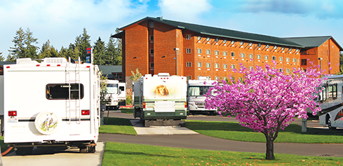
From Cle Elum we headed west on Interstate 90 easily over Snoqualmie Pass (nothing like pulling Vantage Hill!!) into Seattle and then south on Interstate 5 through Tacoma and Olympia before picking up US Highway 101 north to our 3-day stop-over at the Squaxin Island Tribe’s Little Creek Casino and Resort where we found a level concrete pad, full hook-ups, good wifi and nice bathhouse, with 24/7 security, a motorhome friendly gas station on premises, and, if desired a casino/resort/hotel with full amenities. The campground was just off of the Highway. This would be the first time we had ever stayed in a casino campground, and it was really quite nice.
Barbara was excited to see the Pacific Ocean and our first adventure took us on an adventure to explore Ruby Beach, a favorite Washington Coast viewing location for whale and orcas, puffins, and sea otters. Ruby Beach is located in Olympic National Park (!), and at the southern end of the Park’s 65 miles of Pacific Ocean shoreline. When most of us think of a beach we’re picturing (some shade of) white silicon-based sand; however, the Pacific beaches in Northern Washington are not what most of us would call sandy. The shoreline is rocky and dark gravel; the gravel from rock that has been crushed by the ocean.
We had expected sunny and warm, but what we got was overcast and windy. And, while we didn’t find the sea life we had hoped to see we did find a terrifically photogenic landscape that drew us into the visceral experience of the Washington Pacific coast.
Ruby Beach CampgroundGuess Which Way The Wind Blows?FoxgloveBrian’s Favorite Ruby Beach Photograph
We have been to Seattle before, and Brian and Graham had had a chance to visit during their west coast summer baseball trip some 20 years ago. The touristy sites including Pike Place Market, the top of the Space Needle and the Experience Music Project had been thoroughly enjoyed. This time around we found an additional 7 “not to be missed when in Seattle” sites of which we had interest. Unfortunately, 1 of those sites, the Official Bad Art Museum of Art (or OBAMA(!)), had been permanently closed. Guess that left us 6…
Trip Advisor calls North Seattle’s Fremont Neighborhood a quirky, fun-filled bohemian neighborhood. In addition to its many street fairs, coffee shops (it is Seattle after all!), restaurants and nightclubs, colorful storefronts, outdoor concerts and galleries, the neighborhood is a haven for all. As a matter of fact, we were about 2 weeks late for “The Solstice Parade” – an annual outdoor festival on the weekend closest to the summer solstice. which is ushered in by the appearance of 100’s of naked cyclists.
Ever since the Fremont Neighborhood’s Aurora Bridge was erected in 1932 there have been reports of troll sightings underneath. But it wasn’t until 1989 when the city asked the Fremont Arts Council to launch an art competition to rehabilitate the area under the bridge that the Freemont Troll was born.
Steve Badanes “Fremont Troll”
According to Atlas Obscura: “Since no one can absolutely prove that it is not, a group of scientists in a bar reasoned in 1991 that the Fremont Neighborhood is as good a Center of the Universe as any. A guidepost was put up that year to indicate as much…”
Center Of The Universe? Why Not?
Quick – name Seattle’s most famous person? We thought of Bill Gates, Paul Allen, Rainn Wilson, Judy Collins, Macklemore, Ryan Stiles, Carol Channing, Adam West, Gypsy Rose-Lee, and Barbara came up with Sir Mix-A-Lot (from her hip hop days in the early 90’s). Well, to be honest it probably is Bill Gates, but the City’s second most famous person?
Jimi Hendrix is buried at Greenwood Memorial Park.
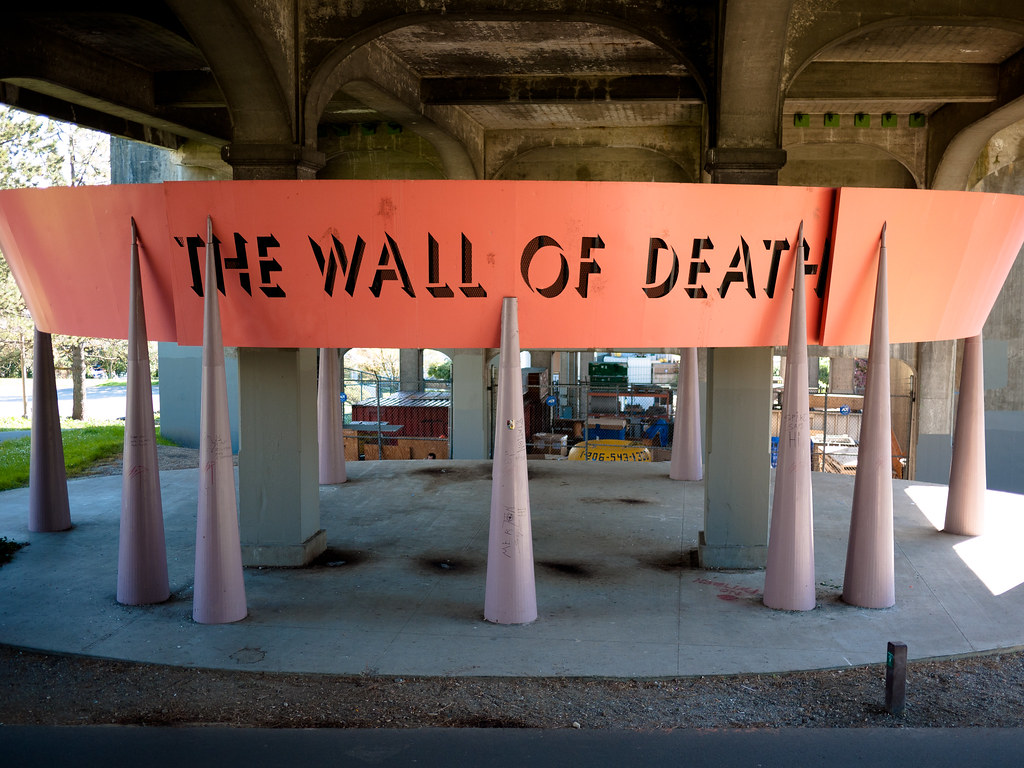
Since1933 “The Wall of Death” has greeted pedestrians, joggers and cyclists using the Fremont Neighborhood’s Burke-Gilman Trail while passing under the University Bridge. It was named by a father-son artist team because of the resemblance to the structure used in the high-risk motordrome sport that was popular at carnivals and sideshows in the early 20th century. Riders on motorbikes or miniature automobiles zoomed around inside a cylindrical track at high speeds, defying the laws of gravity. The structure was known as “The Wall of Death.”
Seattle is the only place we know of where you can get a “bag of dicks.” A true 1950’s style drive-in motif greets diners at any one of the area’s 7 Dick’s Drive-Ins. For the past 37 years this family-owned and run business has been serving burgers, fries, sodas and shakes…only. The product is actually pretty good.
AND, the ownership operates with a genuine practice of treating employees as family – $19/hour starting wage, health care benefits, paid childcare, and tuition assistance are a few of the perks for being an employee.
Seattle’s original farmersmarket and the center of locally sourced, artisan and specialty foods, a whole bunch of restaurants, street performers, a beautiful view of Puget Sound, and home to the Pike Place Fish Market known for its fishmongers’ skill at throwing fish over the customers heads is the Pike Place Market.
Seattle IconMt. Rainer In The Background
But we weren’t in search of flying fish of any variety or for any reason. We were in pursuit of the infamous gum wall! Started in the 1990s when local patrons in line for an improv show at Post Alley’s Market Theater stuck their used gum on the wall, the Gum Wall has grown piece by piece to cover an enormous expanse of brick wall and continues to expand. It’s not easy to find the wall – we received 3 different sets of direction…but just look for and then descend the staircase behind Rachel the Pig.
Rachel
A young woman offered her extra piece of hubba bubba to Brian…his DNA is now merged with the 10’s of hundreds of thousands of other pieces of gum adorning the alley.
Shelton turned out to be a great anchor location for some fun exploration and an introduction to our time in the Pacific Northwest. We had one more planned adventure before we headed on up to Sequim – we just couldn’t miss a day in Mount Rainier National Park.
Barbara and Brian
“It’s not what you look at that matters, it’s what you see.“ – Henry David Thoreau
The extremely high temperatures in the Pacific Northwest have finally somewhat broken. Coeur d’Alene and Spokane will continue to experience record-breaking summer heat, but for the next several days highs will only reach the mid-90s – it was around 72 by 8am the morning we continued our journey west. The high temperatures across the farmland and plains of eastern Washington would follow the pattern expected in Coeur d’Alene and Spokane, but once reaching the foothills of the Cascade Range there’d be a 10-15 degree drop. Positively chilly!
We’re on our way from Coeur d’Alene, or rather Post Falls, Idaho, to the Olympic Peninsula. We’ll have 2 stops before settling in at our campground in Sequim, Washington; one preferred stop in Cle Elum and the other, because of the July 4th weekend in Shelton, our campground in Sequim was fully booked (and we tried to make the reservation in January!) until after the holiday weekend.
It’s roughly 220 miles from the Idaho/Washington border to Cle Elum; 150 miles of which are the aforementioned farmland and plains. BUT 60 miles east of our destination Vantage Hill awaits. The unwary westbound traveler is faced with an unrelenting uphill 10.9 miles with a 0.40 mile elevation change from Vantage, Washington to the Ryegrass Rest Stop at the summit. Although there are brief stretches that flatten out somewhat, stopping unless absolutely necessary would destroy any momentum the vehicle has in pulling up the hill, making it almost impossible to reach the summit. RV Diesel Pushers and Gassers alike struggle up the western grade. Even the Washington Department of Transportation recognizes the long pull of Vantage Hill recommending a stop to allow your vehicle to cool down once you make it to the rest stop. We have to admit that Aimee was tormented during the climb and ran between 10-15 mph at 4500-5000 rpm for quite a bit of the ascent. Brian was afraid of the transmission breaking apart or throwing a piston, but Aimee came through as the champ she is – no harm/no foul!
Cle Elum is a city in Kittitas County, Washington on the upper Yakima River, about 83 miles east of Seattle. For centuries, the land was inhabited by the Kittitas band of the Yakama Tribe, who used the word Tle-el-Lum, meaning swift water, for the nearby Cle Elum River. The first non-Indian settlers arrived in 1883 developing industry – working the coal mines and logging the vast forests. Unfortunately these industries had faded by the early 1960s, but due to Cle Elum’s location along Interstate 90 in the foothills of the Cascade Range, tourism and recreation (skiing) became mainstays in support of the town.
We had hoped to be able to camp in Cle Elum and drive to North Cascades National Park, but our heat-delayed departure from Post Falls caused postponement of visiting the Park – oh well, another time.
Our Mesa friends, Jack and Chris, know Cle Elum well. Jack had gone to college close by, they had lived in Yakima (60 miles south southeast) for quite some time, and had camped throughout the region with their children. Jack had a strong recommendation for pizza in nearby Roslyn (more about that later), and both agreed that the Cle Elum bakery and Owen’s Meats were 2 must stops in town.
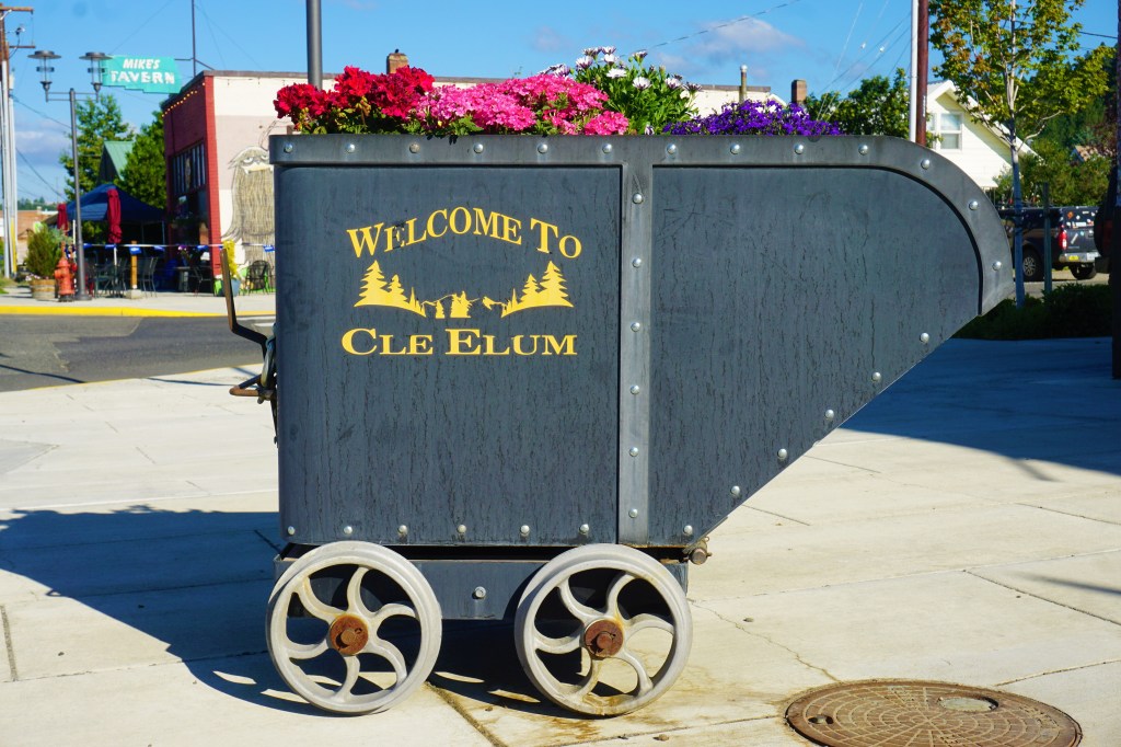
The population of Cle Elum as of the 2018 census was 2004, and as with other small towns we had spent time in, the downtown was busy and thriving. Cle Elum and South Cle Elum are separated by the (you guessed it) Cle Elum River, a tributary of the Yakima River. Main Street is lined with small businesses; residential dwellings begin around each and every corner.
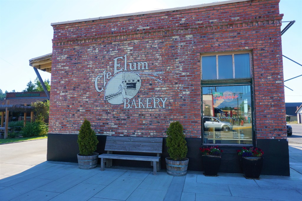
Opened in 1906, owned and operated by 3 generations of the same family, this is a traditional bakery offering “homemade” breads, deserts, breakfast sandwiches, coffee and (!) donuts. Jack and Chris thought the donuts were excellent so we just had to order up a half dozen, and somehow a loaf of French bread found its way into our purchase as well. The bakery goods were fresh, and the bread wonderful. Given the build-up there was some disappointment as we felt the donuts were just ok – nothing to get too excited about.
“The Candy Store For The Carnivore.”
On the other hand should you be in the area or near one of their meat machines (!), Owens Meats is worth going out of your way to find. Sure they will butcher your freshly dressed game…but that’s for the locals and visiting hunters.
Opened in 1887, 2 years before Washington became a state, Owens Meats is a purveyor of some of the best looking cuts of meat I’ve seen in a long time – well marbled beef and leaner less expensive cuts, well trimmed pork and lamb, choice looking chicken and fresh homemade polish/bratwurst/Italian/smoked/cheddarwurst/apple link sausage; smoked and/or marinated meats, jerky, meat sticks and pepperoni (sold by the foot) as well as mustards, marinades and seasoning mixes were all on display and just wanting to follow us home. I’d love to report that we spent our children’s inheritance at Owen’s Meats, but our freezer in Aimee is just too small. We did settle on a foot of jalapeno smoked pepperoni, and a half pound of their “good stuff” – a delicious blend of the various varieties of jerky, pepperoni and meat sticks tossed together with cheddar and pepper jack cheese. Yum!
How about that aforementioned Meat Machine? Owens Meats has placed their meat machines at 18 locations in Yakima, Cle Elum, Seattle and Tacoma. The machines vend processed meat products…their jerky, pepperoni, meat sticks, and bags of the “good stuff.” Enjoy meat? These machines provide a fix for the carnivore in each of us.
We checked out Atlas Obscura, and identified 4 pretty cool places to visit: Leavenworth Bavarian Village, Dick and Jane’s Spot, the Statute of Washoe the Chimpanzee, and Stephen Ristine’s Wheelbarrow Tree.
Ellensburg is 25 miles east of Cle Elum on Interstate 90.
Washoe the Chimpanzee lived in Ellensburg on the campus of Central Washington University with four other chimpanzees. She and her companions were subjects in an animal research experiment on animal language acquisition at The University and were the first non-humans to learn to communicate using American Sign Language (ASL), learning approximately 350 signs. The chimpanzees came to use ASL to actively communicate with each other as well as with humans. Washoe is special as she was the first chimpanzee to engage as a teacher, and taught sign language to other chimpanzees as well as her offspring. She passed away in 2007.
Washoe Signing “Friend”
Leavenworth, Washington is 52 miles north of Cle Elum, and was a mountain town through which rails were laid in support of a thriving timber industry. But within a half-a-century the railroad found alternative more lucrative routes and the Leavenworth line was abandoned – the timber industry and its jobs followed. Leavenworth teetered on the brink of failure for decades as people left and the streets emptied. In the 1960s, in a rather remarkable example of communal effort, the town decided to become a seasonal tourist destination. The snowcapped mountains and miles of natural beauty reminded locals of the Bavarian Alps, and a risky development involving the total reconstruction of the town into an Alpine Mountain Town was undertaken: innkeepers and shop owners on main street redesigned buildings from head to toe, inside and out, in the style of the Bavarian Villages “of old.” Using themes related to Bavarian history and marketing the uniqueness of its festivals the novelty of the town caught on. Quite simply the plan worked.
Even Micky D’s Tried To Fit In
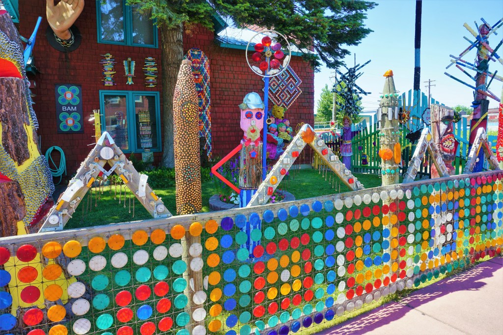
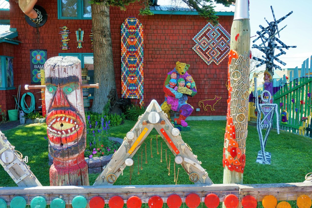
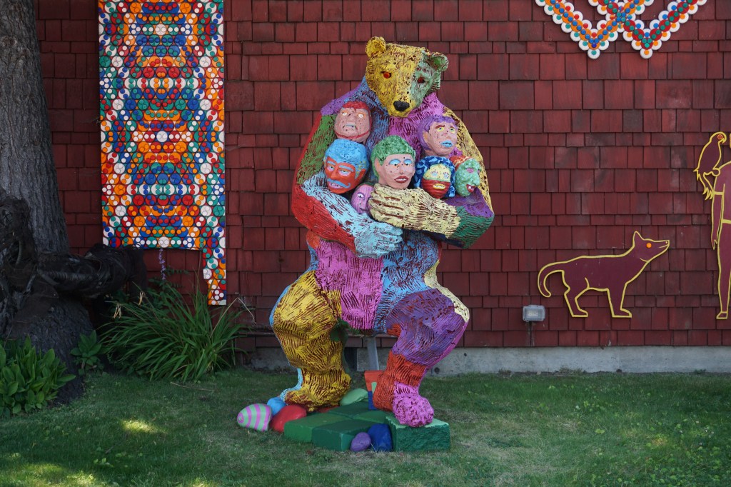
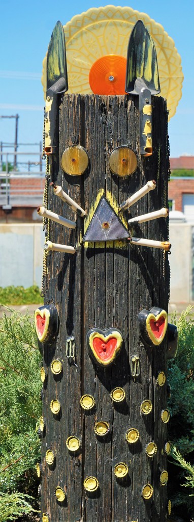
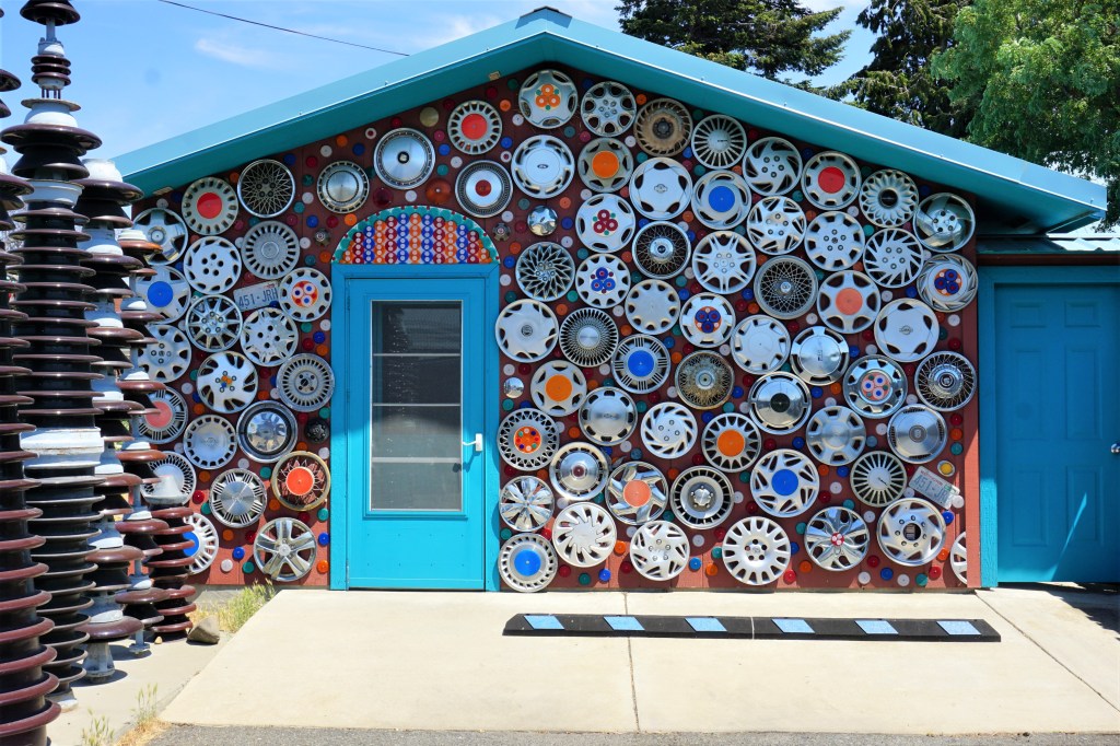
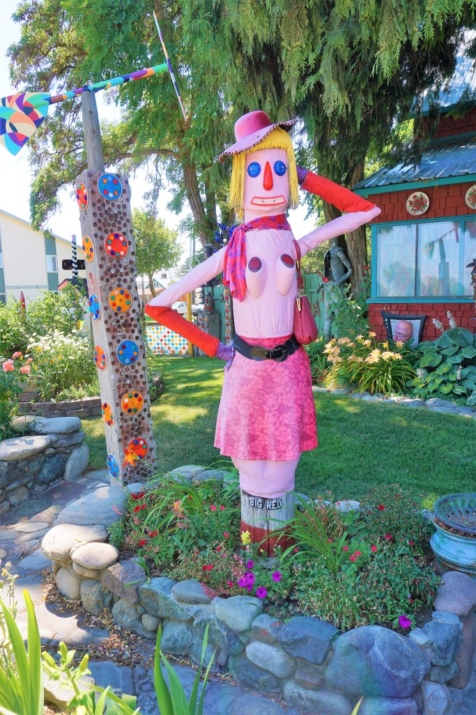
In 1978 Dick Elliot and Jane Orleman bought a home in Ellensburg and, as artists, began decorating their yard with a colorful collection representative of their work. Dick and Jane as well as other “outdoor” folk artists throughout the Pacific Northwest contributed to their outdoor art “garden.” Paintings, sculptures, bottle trees, geometric abstractions and recognizable patterns using reflectors are on unobstructed display for visitors to enjoy.
One statue is a source of controversy though – seeming to greet the town’s officers of the law with her gregarious smile and suggestive pose, “Big Red” is a topless statue that directly faces the Elensburg Police Department building!
Big RedLocal Politicians? Off With Their Heads!The Tin ManUltimate Tourist?Hello Boys!
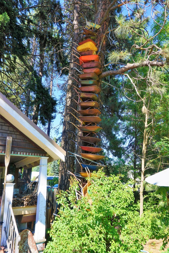
Stephen Ristine’s Wheelbarrow Tree, or more properly, Stephen and MaryJane’s Home is a crazy accumulation of found stuff (no other words will do!) tossed together inside and out of a basic cabin that had been used by the US Forestry Service Superintendent, had been bought for $1 by Stephen and MaryJane from the federal government, and has been their home for the past 30 years or more. Stephen is a handyman and contractor who restores/flips the small (we’re talking 500 square feet or less) single-family homes that can be found all over this region of the Country. Whatever he finds he saves. Out of respect for their privacy Brian didn’t take pictures inside the house, but as you enter there are 3 female mannequins dressed in military uniforms holding loaded rifles; the kitchen boasts a wood-burning cookstove, an industrial floor scale and clock that could be used on a city hall building, and the basement is 2+ stories tall and houses an amazing amount of tools (including over 100 hammers, 50 or so logging axes and saws), enough hardware to compete with Lowes or Home Depot, a weapons room, and an emergency escape door. By the way, the only reason Brian was able to see the basement was that he asked how Stephen and MaryJane stayed cool during the recent extreme heat wave – “come look” says Stephen. The basement was damp, but at least 25-30 degrees cooler than topside. We had come to see the Wheelbarrow Tree, but Stephen and MaryJane were outside and since we were asking to be on their property we felt it proper to ask permission – a conversation was struck up and the tour commenced.
Stephen let us know that the “Tree” was started on a whim – his family had an accumulation of wheelbarrows that were just laying around rusting. Once the “Tree” was begun people started dropping off wheelbarrows in his yard. The project “took off,” and is now in its second and third generations. For a more thorough look at the Wheelbarrow Tree check out the YouTube video “starring” Stephen by googling Wheel Barrow Tower of Cle Elum.
We found so much more than a Wheelbarrow Tree. Thank you again Atlas Obscura!
Old Fashioned Bear TrapNext Generation’s Wheelbarrow Tree In The Works
3.5 miles northwest of Cle Elum is Roslyn, Washington. Remember our mentioning Jack, who went to school at Central Washington University? He told us that we needed to visit Roslyn for 3 reasons: the opening and many scenes from the TV series Northern Exposure was filmed there; Village Pizza was top notch (and Jack is a foodie), and back in the day, 1973, a friend of his “streaked” The Brick Saloon and cracked the bar by jumping up onto it. By the way, The Brick Saloon claims to be Washington’s oldest continuously operating bar.
We Asked About The Broken Bar…No One Working Was Alive In 1973 When The Incident Allegedly Took PlaceExcellent Pizza! A Novelty Note: The Restaurant Provides Honey On The Tables As A Dip For The Crust.
On Barbara’s bucket list was a trip to Snoqualmie Falls – 55 miles west of Cle Elum and right off of Interstate 90. Mother Nature sure cooperated with us while we were on our way to The Falls
o
It is considered the most famous waterfall in Washington, and year after year is the most visited. Snoqualmie Falls is 268-feet high with the width ranging from 50-to-150 feet, depending on water levels. There’s an upper observation area which does give a nice view of the falls. There’s a short hike down to the river and then an easy walk to the end of a boardwalk that affords a chance to enjoy the forest and a different view of Snoqualmie Falls.
From the upper observation deck…
…and along the trail…
Orange Day LilySpecies Of BlackberryJapanese Meadowsweet
…from the lower observation deck…
We had figured on Cle Elum to be a quiet stop-over before we excitedly made our long-awaited journey into the Olympic Peninsula. Boy, how WRONG we were!
Barbara and Brian
“It’s not what you look at that matters, it’s what you see.“ – Henry David Thoreau
If 2020 had been untainted by the pandemic we would have started out in the spring making our way in early summer to Coeur d’Alene before turning westward towards the Olympic Peninsula.
Coeur d’Alene was to be summer 2021’s third anchor stop; grandkids, Voyageurs National Park and then Coeur d’Alene – dig? But we almost had to change our plans. The Coeur d’Alene triathlon was scheduled for part of the time we wanted to be in town – finding a decently rated campground was tough – our first choice had been booked for almost a year! But John and Cheryl Williams had made plans to be in town, and we wouldn’t miss a time to reunite, catch-up and spend time with BFF’s from last winter in Mesa. Fortunately 12 miles to the west we found the perfect campground in Post Falls, Idaho.
June temperatures in Coeur d’Alene average a high of 75 degrees Fahrenheit and low of 48; in July it becomes a bit warmer averaging 85/53. When we arrived the forecast for the next couple of days called for unusually hot temperatures with highs nearing 100 degrees and overnight lows into the low 80s/high 70s. And then the potential for unknown high temperatures was very, very possible. We had planned to see the sights, visit Spokane and bicycle a rails to trails ride on the Idaho/Montana border – we couldn’t allow a little heat to slow us down.
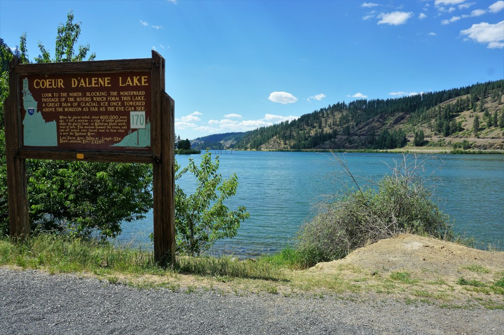
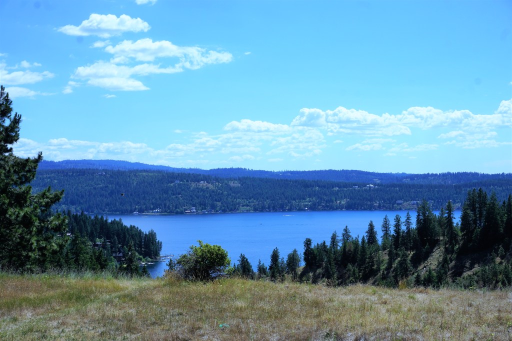
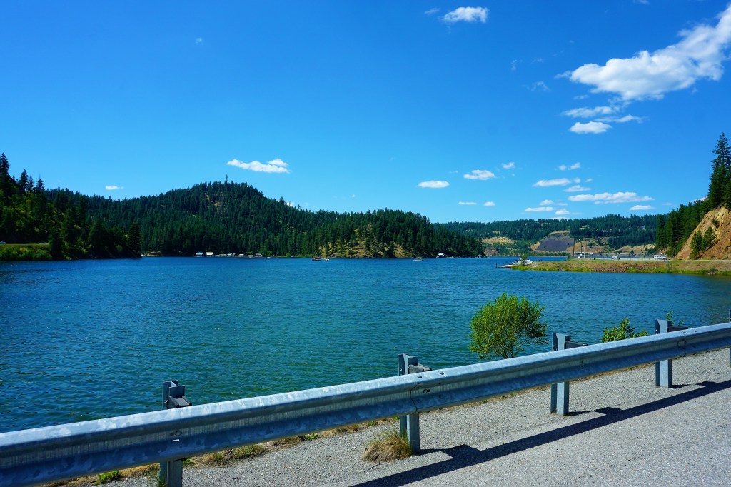
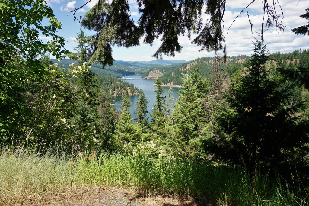
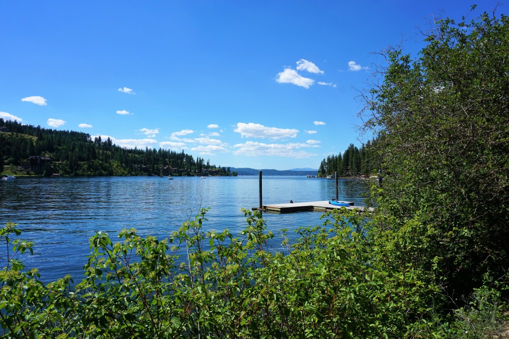
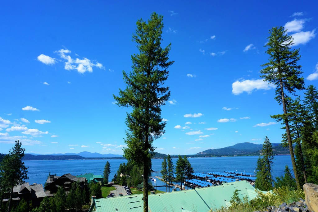
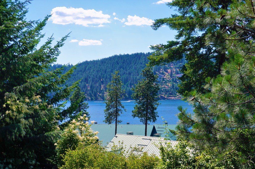
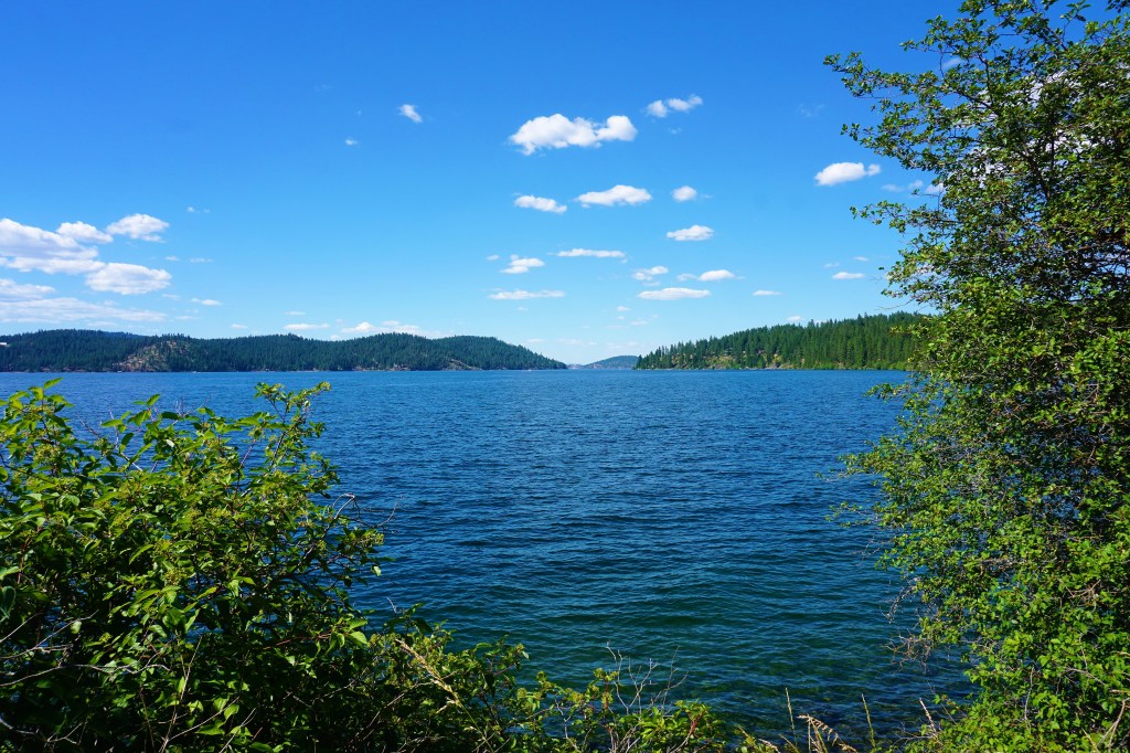
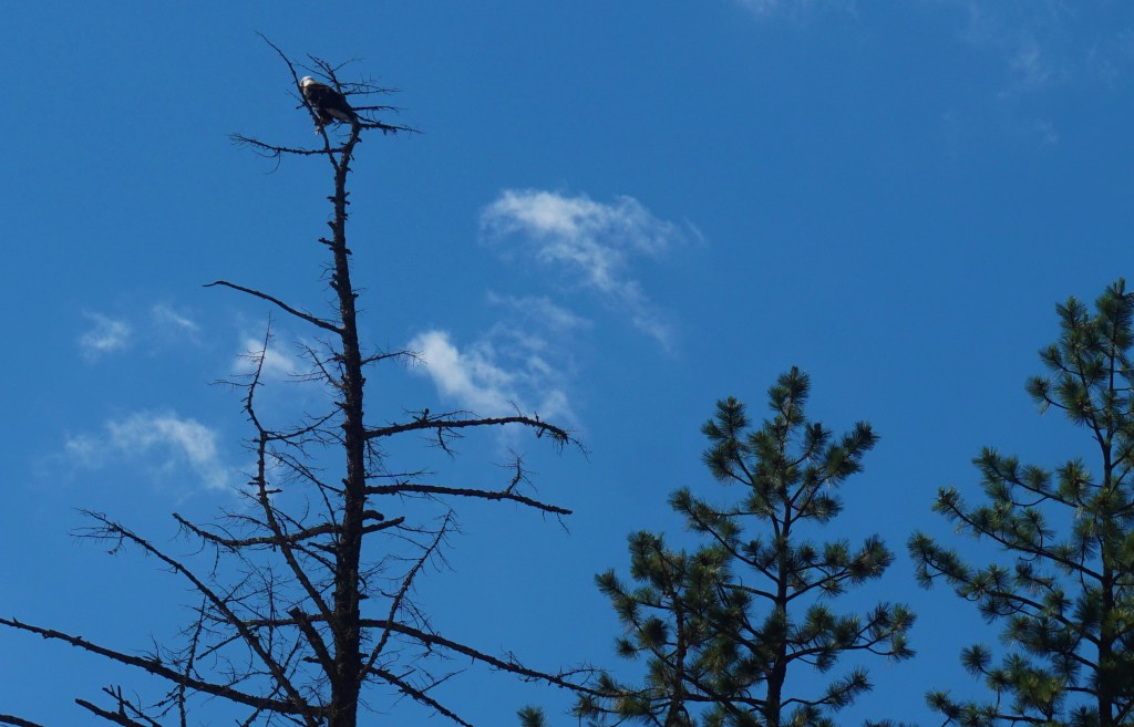
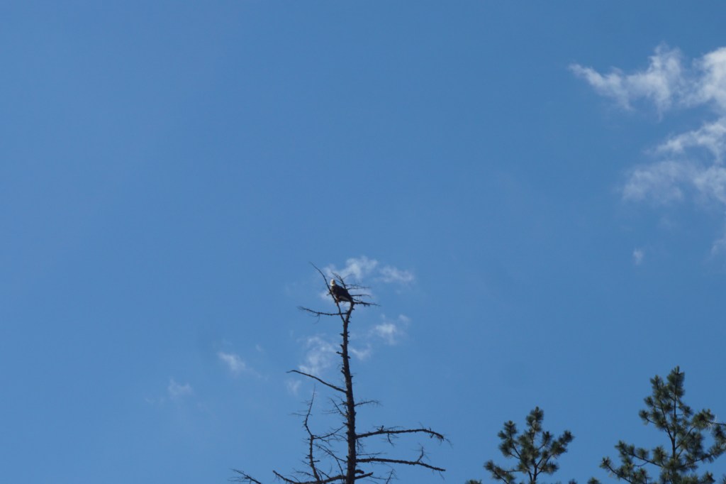
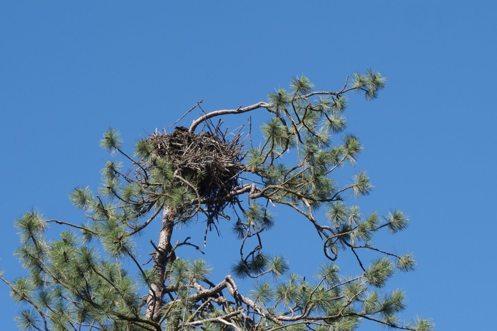
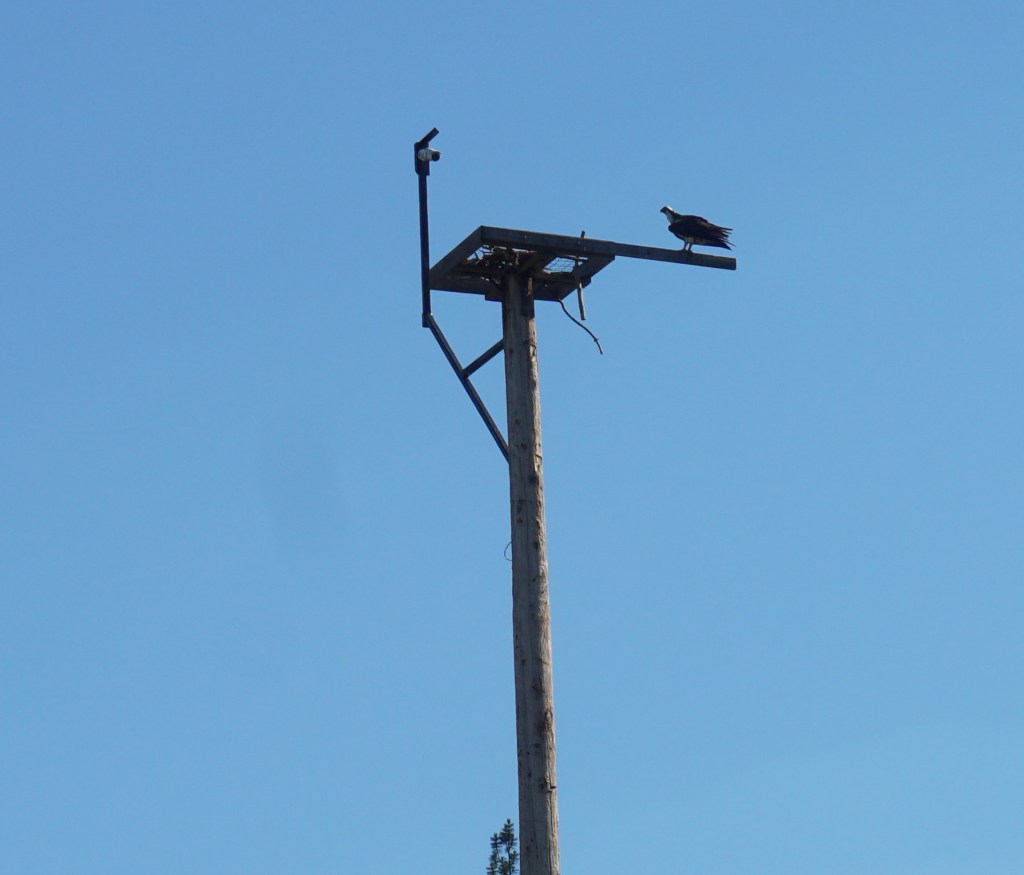
We discovered during a long trip along the Lake Coeur d’Alene scenic by-pass that the Lake is a water lover’s paradise with beautiful scenery, many, many boat slips, and 109 miles of shoreline. The Lake is 25 miles at its longest and averages 1-3 miles wide. The area is an Osprey hatchery in spring and early summer, and as an annual stop for the winter’s bald eagle migration.
Field GarlicField GarlicA Little Late for The Bald Eagle Migration – This One Must Be A ResidentOsprey NestCoeur d’Alene Is Home To The Largest Number Of Mating Osprey Pairs In The US
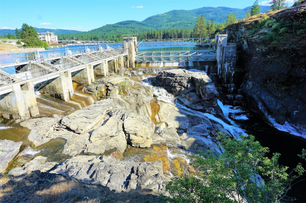
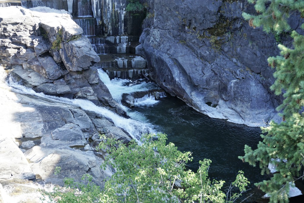
We took a very nice walk through one of Post Falls city parks – Falls Park. What we found was a delightful family- friendly city park with placards describing the early history of the city, and the importance of its founder’s lumber mill business to the growth of the town.
What we didn’t expect was how much the Western US drought affected the Spokane River.
Post Falls FallsFlume’s Are Open…Drought Has Substantially Reduced The Water Flow
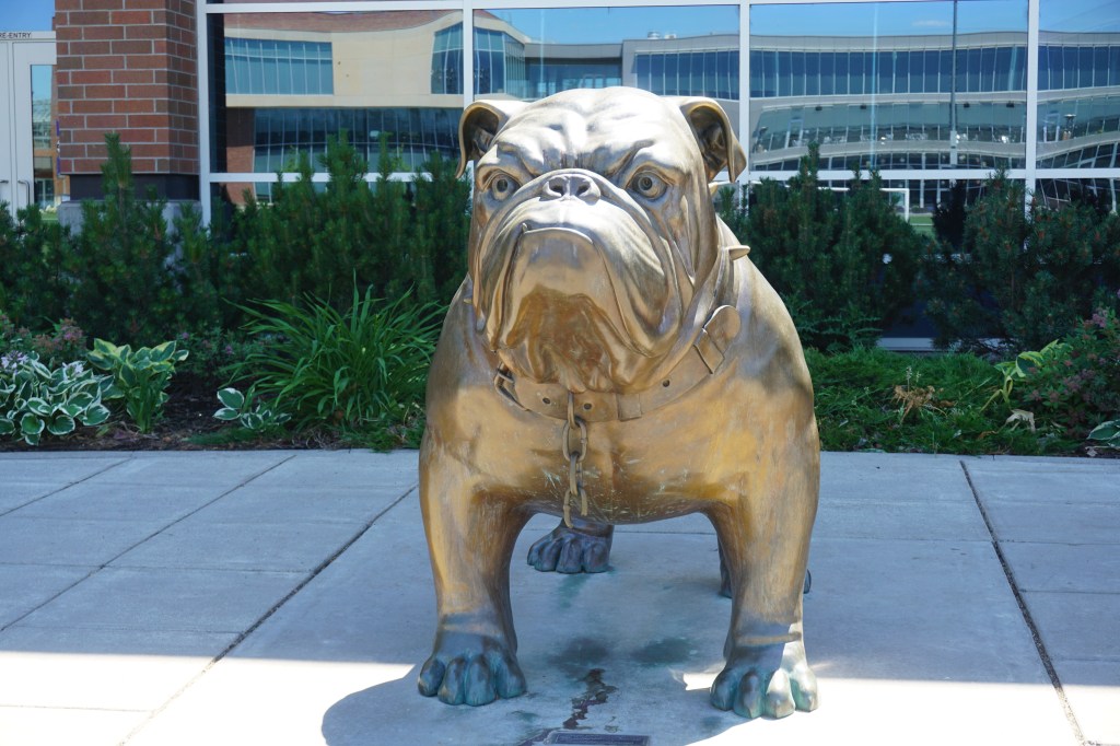
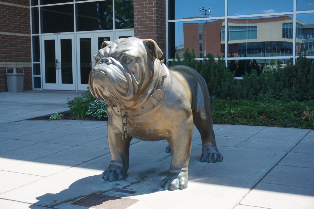
Barbara’s best friend earned her undergraduate degree from Gonzaga University in Spokane – which is approximately 20 miles west of Post Falls. We visited campus, wanting to surprise Susan with a picture of the school’s mascot, The Bulldog, in order to also let her know we were there, and, of course, thinking of her.
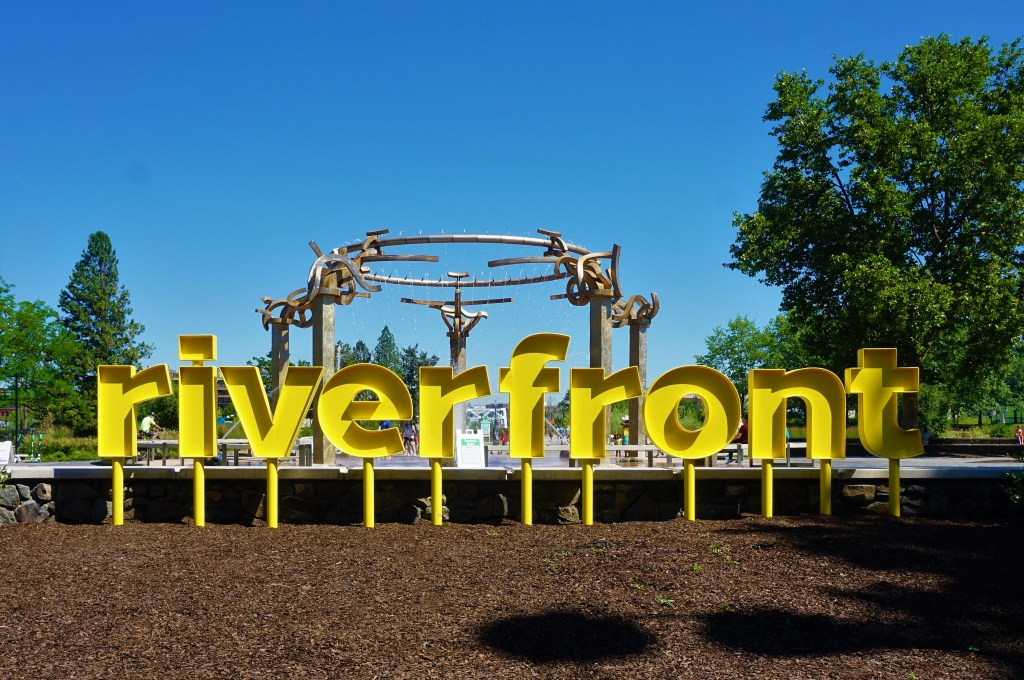
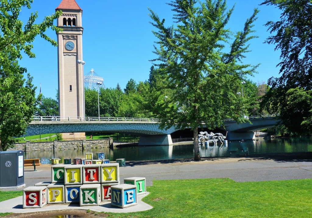
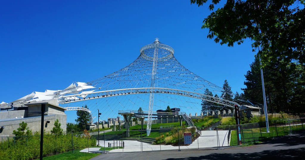
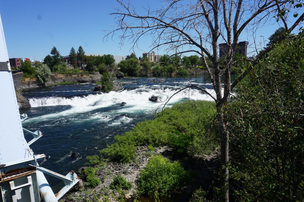
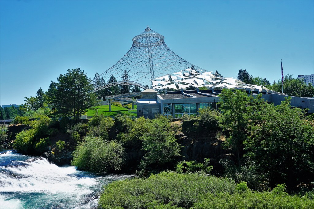
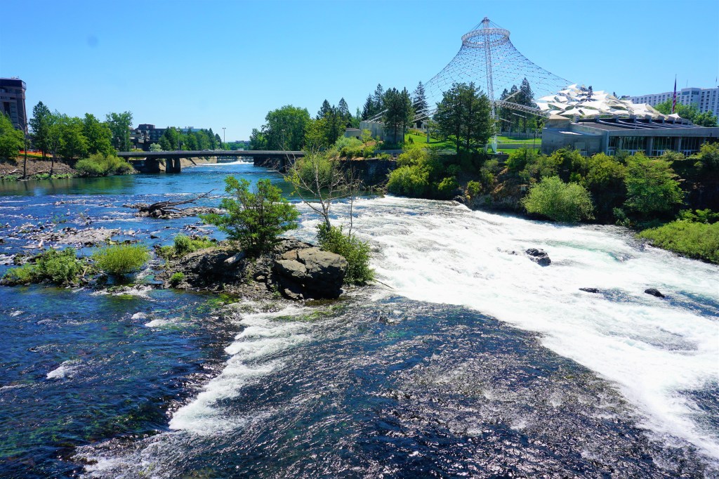
We had done our homework and found a number of places in Spokane worth a stop. First up on the list was Riverfront Park.
Splash Pad In The Background
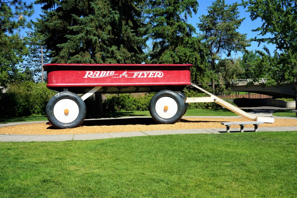
When we entered the park from the north (?) what greeted us is a slide made to look like a little red wagon. How cool is that?
Centennial Trail is the common name given to the walkways in Riverside Park. Throughout the Park the views were exceptional…
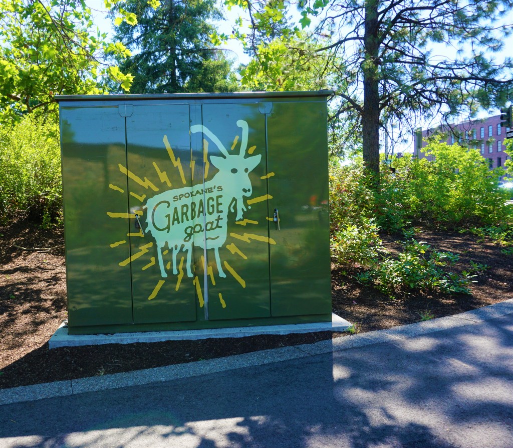
Atlas Obscura recommended finding Spokane’s Garbage Eating Goat in Riverside Park. A favorite of kids and families the mechanical goat does indeed grab trash from the beholder’s hand and makes a bit of a munching sound before coming back to rest.
An Atlas Obscura Spokane FavoriteFeed Me!
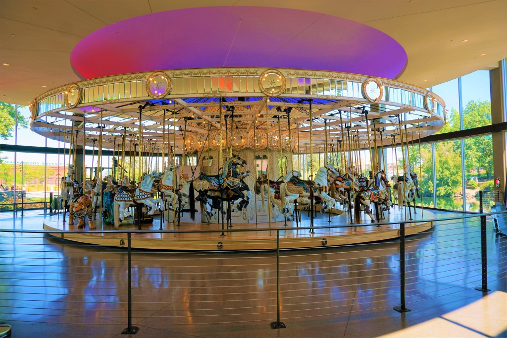
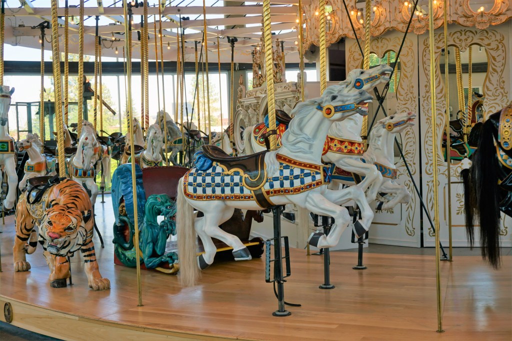
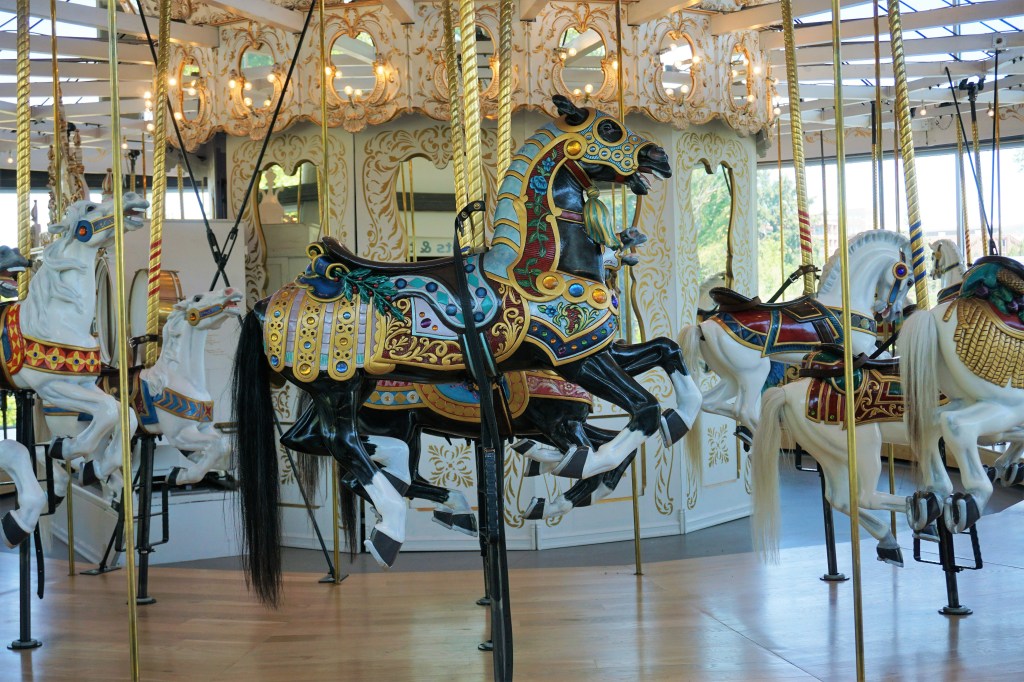
For kids of all ages there is the chance to ride on the beautifully re-constructed 1909 Looff Carousel…
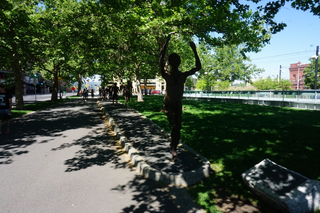
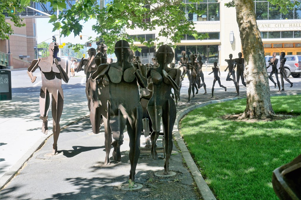
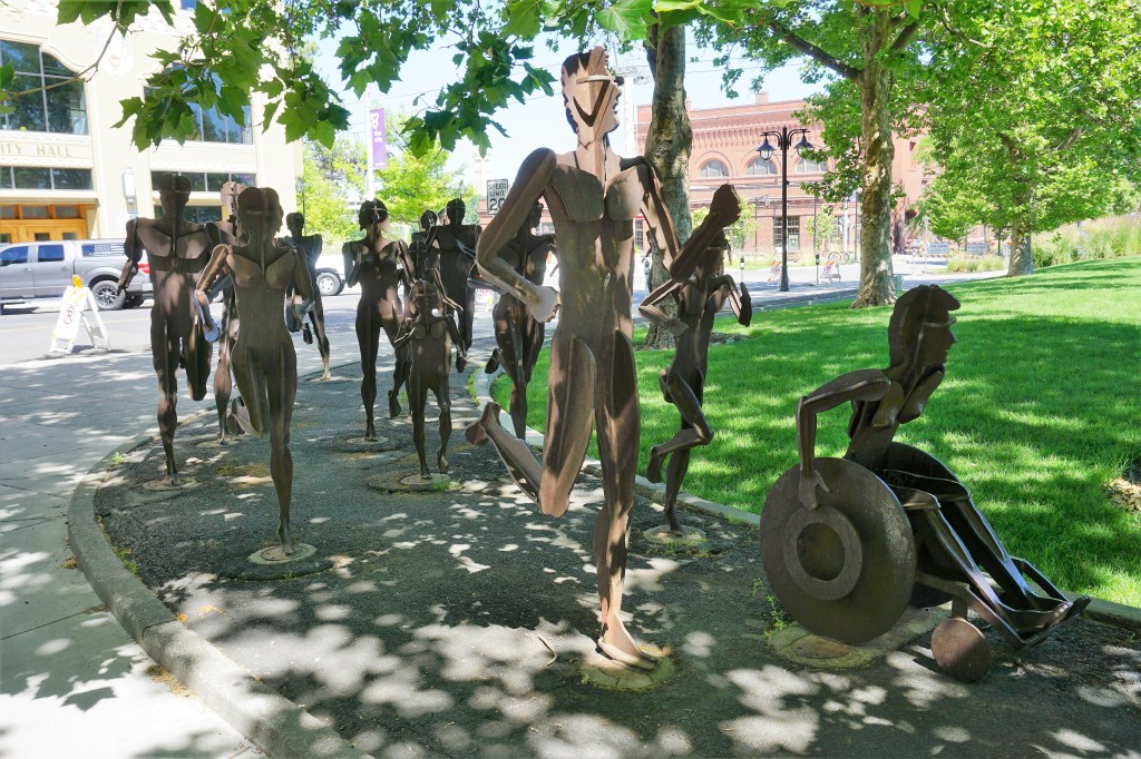
Commemorating the Spokane tradition of Bloomsday a corten steel sculpture depicts runners of all kinds. Bloomsday claims to be the largest timed road running race in the world.
By the way, we had no idea what Bloomsday is or why it is celebrated. From google: “Bloomsday is a commemoration and celebration of the life of Irish writer James Joyce, observed annually in Dublin and elsewhere on 16 June, the day his 1922 novel Ulysses was published, and the date of his first outing with his wife-to-be, Nora Barnacle, and named after its protagonist Leopold Bloom.” So there you have it – Bloomsday!?
This is drought affected 9 Mile Falls…
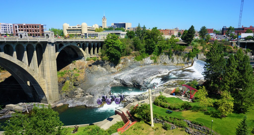
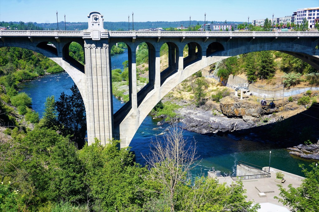
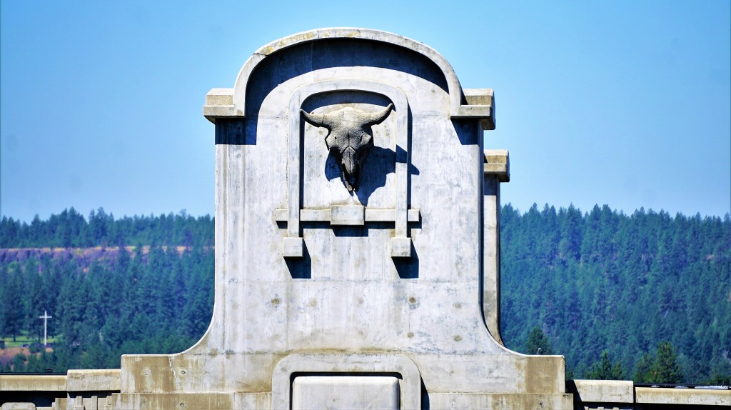
Another Atlas Obscura must see is the the bison head guardians mounted on the pedestrian pavilions of the Monroe Street Bridge. The pale, unconventional ornaments peer out over both the people crossing the overpass and the river “rushing” below.
Originally built as the U.S. Federal Pavilion for Expo ’74, the Pavilion was a gift to Spokane from the United States government. Since then the Pavilion has been turned into a flexible use event space able to host everything from the Hoopfest Nike Court game and the Bloomsday Award Ceremony to a summer concert series and an outdoor giant screen film festival. During the summer months there are scheduled evening light shows.
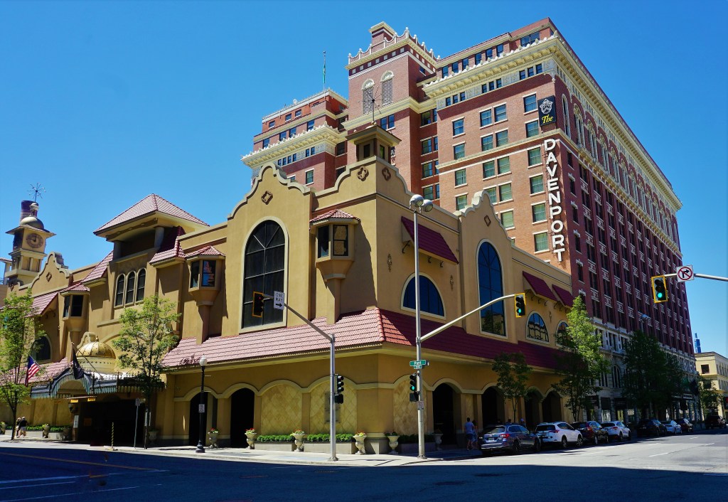
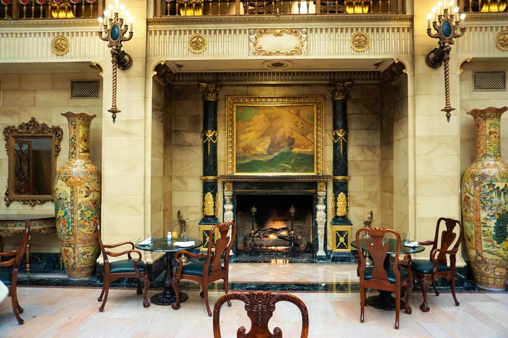
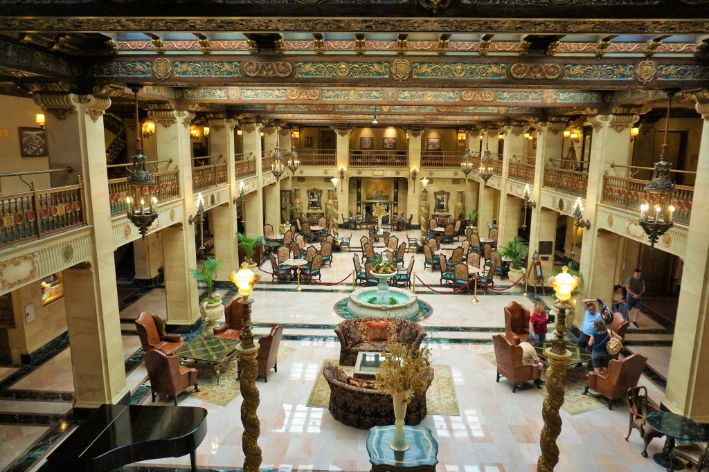
Within walking distance of Riverside Park is the Historic Davenport Hotel. When it opened in 1914, The Davenport Hotel, was the “most modern hostelry” in the United States. It was the first hotel with air conditioning, a pipe organ, a central vacuum system, housekeeping carts and accordion ballroom doors. Unfortunately, by 1985 it was in disrepair and had been shut down. Local entrepreneurs Walt and Karen Worthy bought the hotel in 2000 and set about making it grand again. During the renovation, the hand-painted frescoes, ornate woodwork and European-inspired marble were all meticulously restored, including the genuine gold leaf around the lobby hearth and the year-round lit fireplace – both hallmarks of Davenport hospitality since the hotel opened its doors more than a century ago. Grand rooms like the Spanish Renaissance lobby or the Hall of Doges, Spokane’s oldest and most exquisite ballroom, draw tourists and architectural aficionados alike. Such extraordinary features have helped The Historic Davenport Hotel earn a prized spot on the National Register of Historic Places. The Hotel generously provides a booklet to assist in visitors’ self-guided tours.
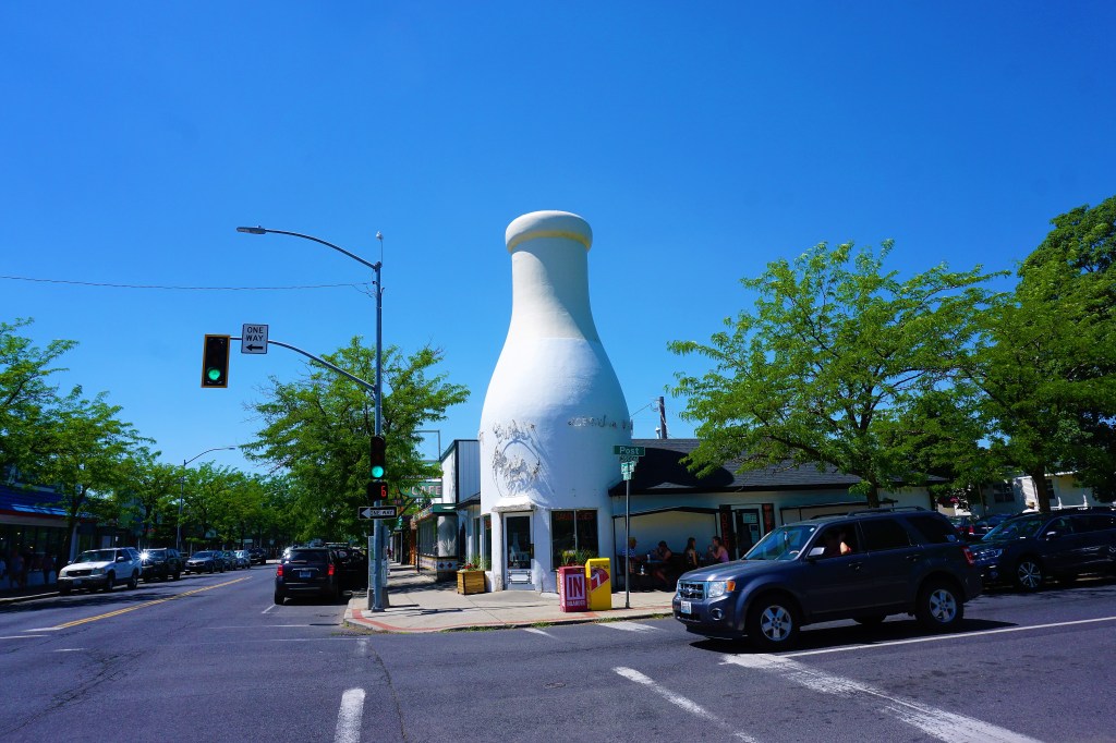
When the Benewah Creamery opened a store on West Garland Avenue and North Post Street in Spokane in 1935, it used a rather fitting beacon for dairy lovers: a giant milk bottle. The creamery was originally one of several retail outlets owned by dairy merchant Paul Newport. Using local farmers’ raw milk to make products such as cheese and ice cream, the Newport family sold their wares at the store until it went out of business in 1974. By that point, the unusual building had become a Spokane landmark. Even when new owners transformed it into a store selling second-hand furniture and knickknacks, the milk bottle remained. The looming white structure almost disappeared for good when a fire tore into the building in 2011. The milk bottle was restored, and today it graces a diner—Mary Lou’s Milk Bottle—that sells burgers, sandwiches, and, naturally, highly praised milkshakes and ice creams. Had to stop in for a most delicious lunch, and even Barbara, the empress of ice cream, found the milk shakes to be the real deal – first class!
Penn State University shares something in common with Washington State University. Both universities offer various agricultural majors; the Knott Dairy Center at WSU and the Penn State Creamery are focused on teaching and research associated with the dairy industry and dairy products. While Penn State may be most widely recognized for its ice cream, WSU is known for a sharp white cheddar cheese: Cougar Gold. FYI-it’s the Washington State University Cougars.
We listened to our friends the McGibbons and the Williams rave about Cougar Gold, and thought it would be a nice surprise, as long as we were in the neighborhood, to pick some up for them.
In doing our research we found out that WSU’s dairy store on the main campus in Pullman was the only location guaranteed to stock Cougar Gold for sale, but the store was closed the days we could have made the trip. Next best locations according to the internet would be at either of the WSU Cougar stores in Spokane. Yeah? One store had been closed and not reopened due to the covid pandemic, and, well, we just couldn’t find the other store. So maybe, the internet suggested, Trader Joe’s might just perchance maybe conceivably perhaps have a supply in stock – no such luck. Undaunted, we asked the store manager at Trader Joe’s and she directed us to Ferrante S Marketplace Cafe, an Italian Restaurant located in Spokane’s South Hill. A quick call confirmed that a supply was available, and 25 minutes later 2 cans (only sold in 30 ounce cans) of the delicious aged curds were in our possession.
For the record, it is pretty damn good cheese. Of course it would have to be after our hunt for Cougar Gold!
We were able to share a can of Cougar Gold with John and Cheryl Williams – they pulled into Coeur d’Alene the next day. We had a superb reunion, played a mess of cribbage, and just flat out enjoyed our time together.
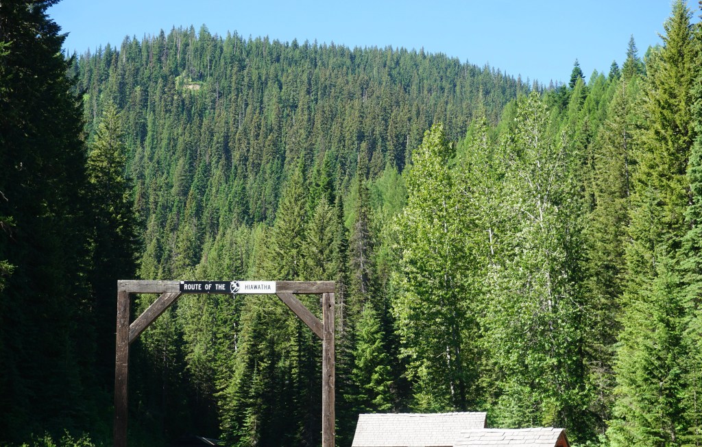
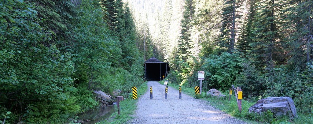
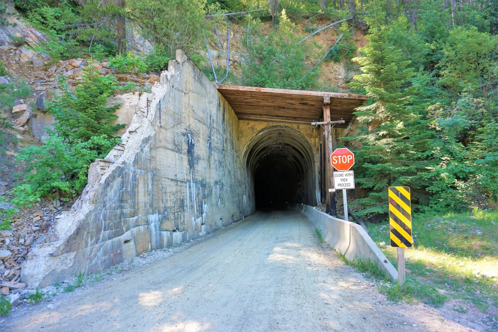
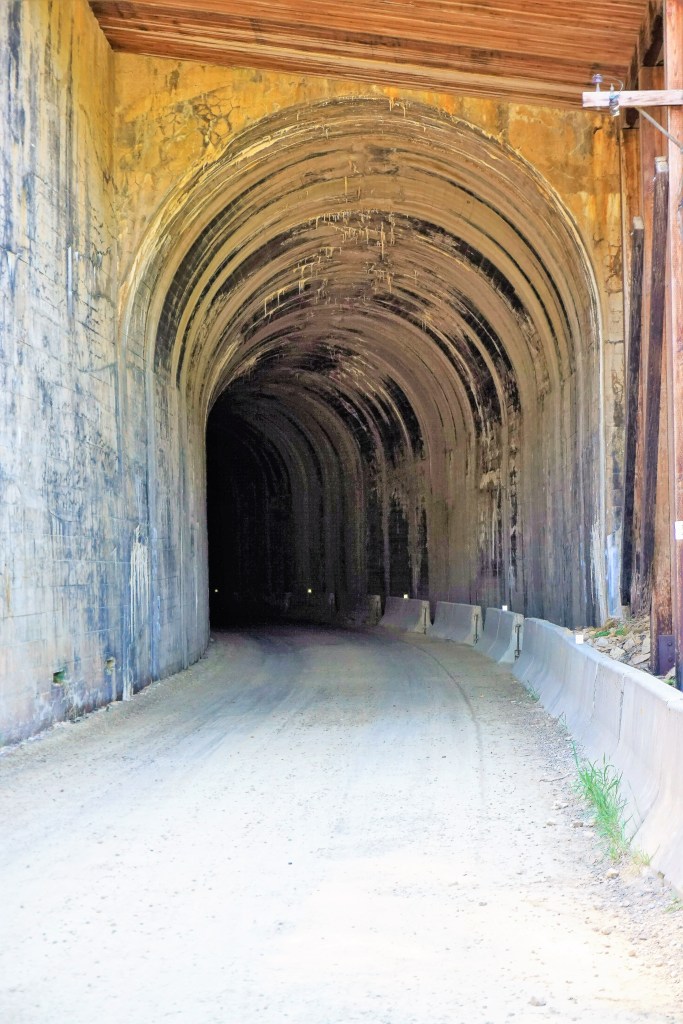
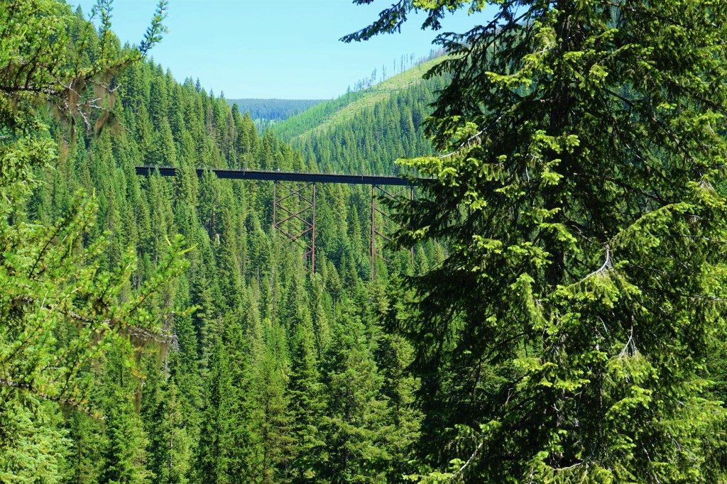
Part of our plan while staying in Coeur d’Alene was to spend time with Mesa friends Jerry and Barb Beck who have a home 7 miles north in Hayden, Idaho. But during the time we were in town a 100th birthday party for Barb’s mother some 200 miles away had already been scheduled. Unfortunate. However, Barb suggested that we not miss The Hiawatha, a rails to trails bicycle ride located on the border of Montana and Idaho.
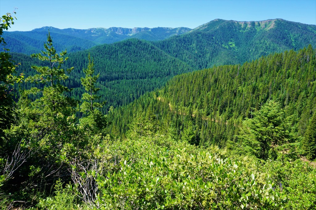
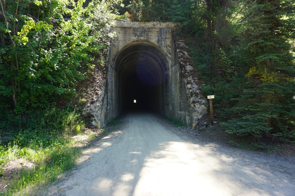
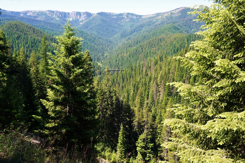
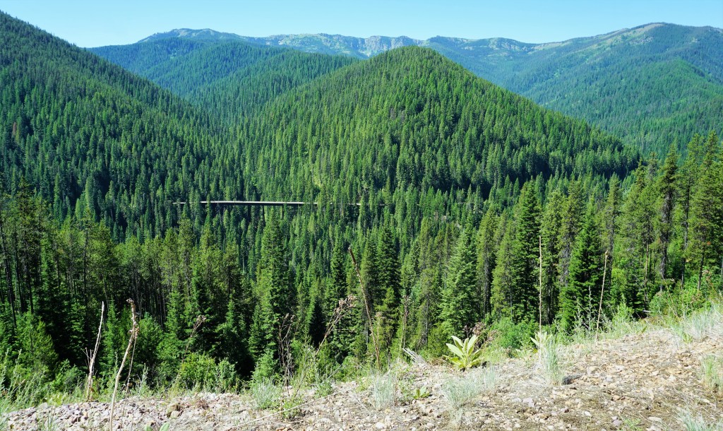
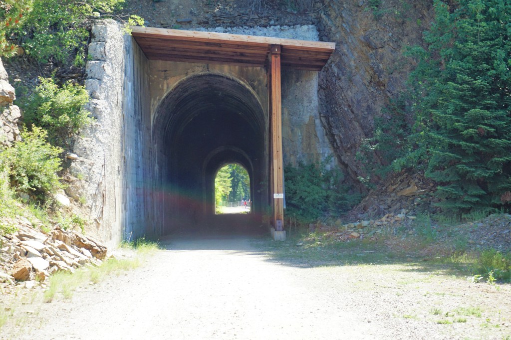
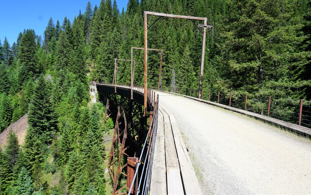
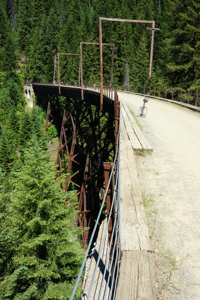
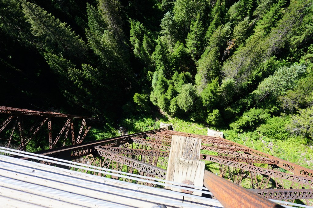
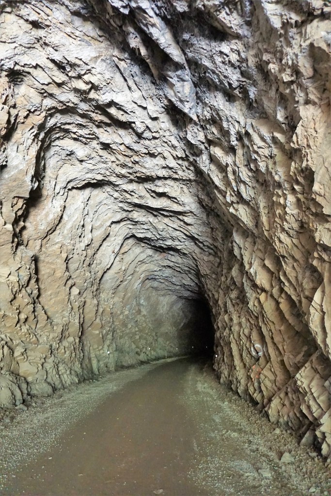
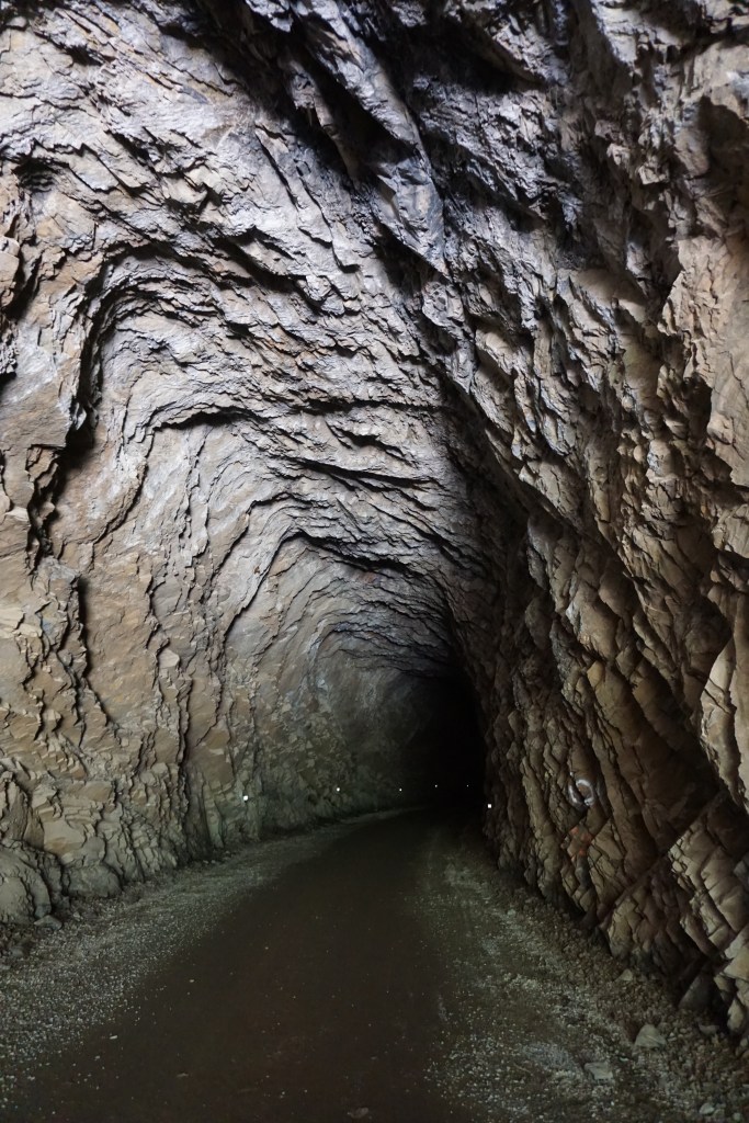
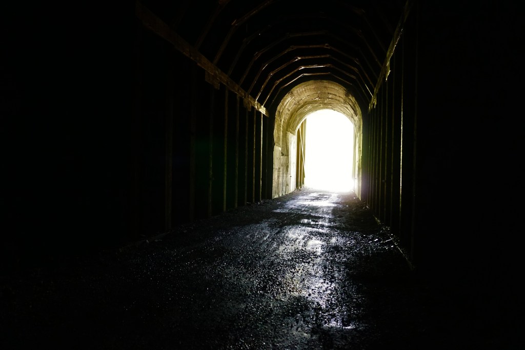
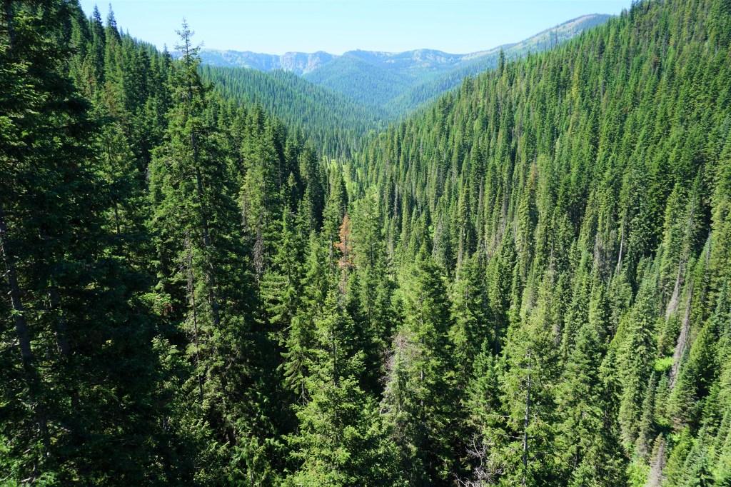
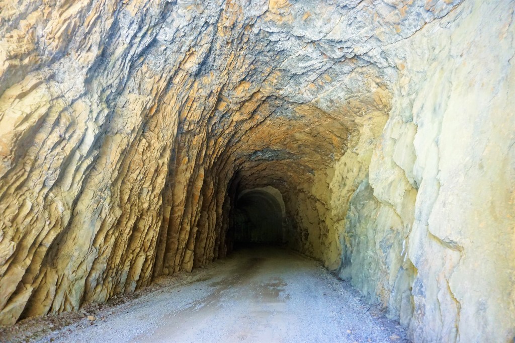
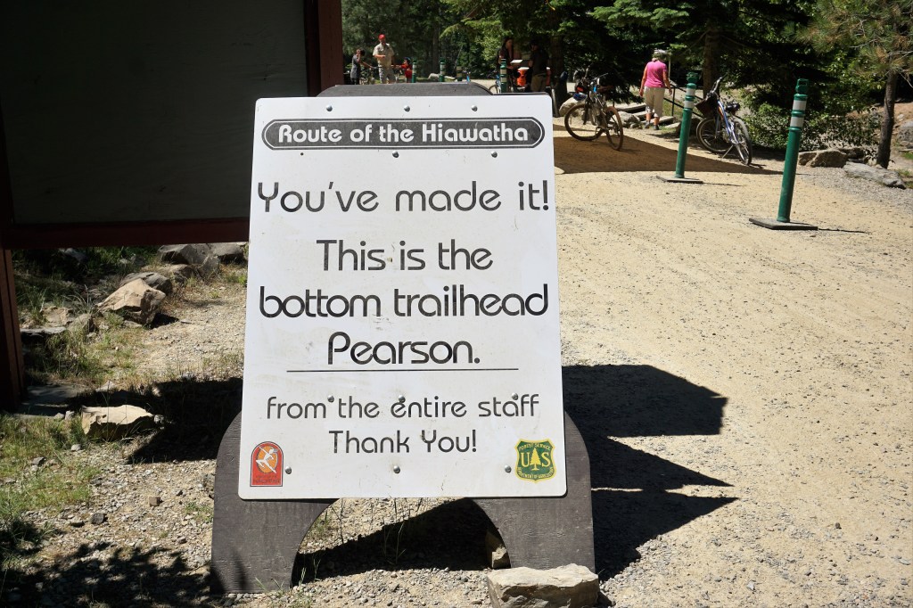
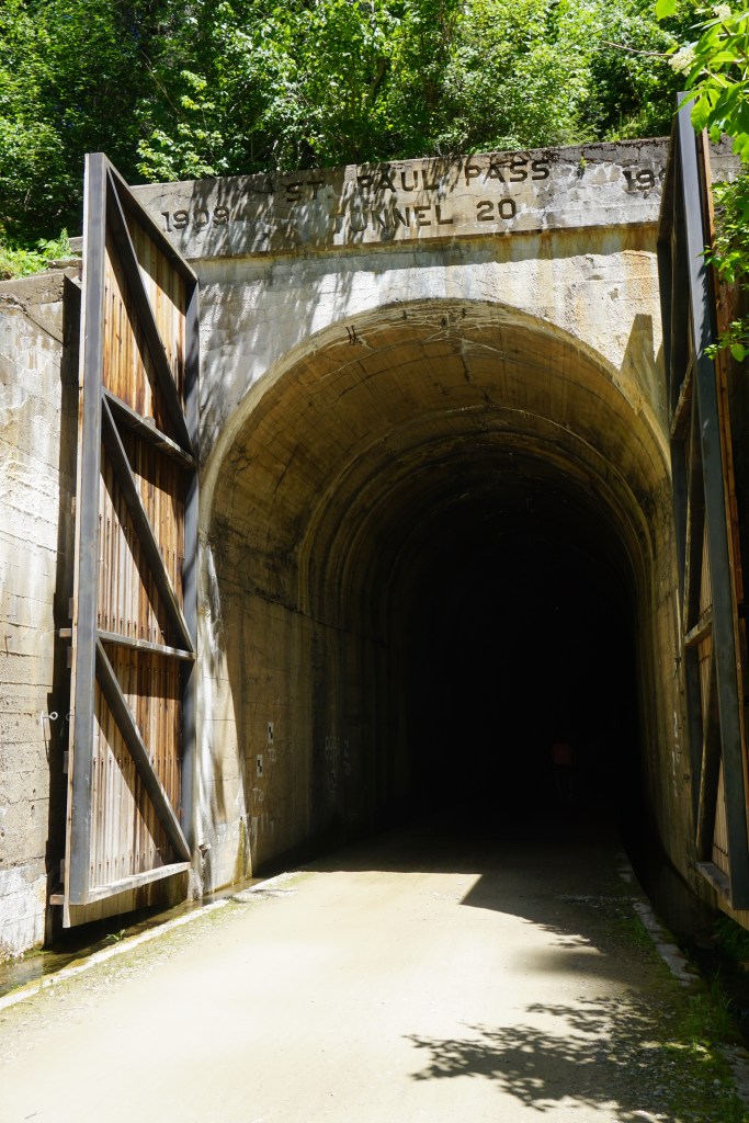
The Hiawatha is a 15 mile 1.5 degree downhill bicycle ride that goes through 10 tunnels and over 7 trestles along the way. The longest tunnel is 1.67 miles of pitch darkness, which also starts and finishes the ride; a shuttle returns riders from the bottom to just short of the tunnel which then must be ridden through to return to the parking lot. We made our reservations. Tickets for the trail and the return shuttle are picked up at a location a few miles from the trailhead. Saddle up, helmet on, make sure your flashlight is working and off we went. It is an easy fun ride for all ages and the views are magnificent.
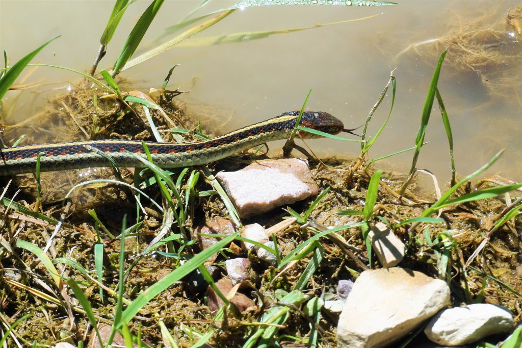
Starting PointApproaching The 1.67 Mile TunnelEntrance To The 1.67 Mile TunnelNotice The Trestle We Would Cross?Notice Another Trestle We Would Cross?We Encountered This Little Fella Along The Way
What no one expected was that the summer of 2021 would include “satanic” heat of biblical proportions exactly when we would be in town. We’re talking an atmospheric inversion/heat dome bringing record high temperatures and shattering heat records stretching from Montana to the Pacific coast…117 degrees Fahrenheit in Portland; multiple days in Coeur d’Alene around 109. Brutal.
Heading west from Coeur d’Alene our next stop would be Cle Elum, Washington. The route from here to there would have us travel across the middle of the state through the eastern part of Washington. It’s high desert and farm country, flat and not much in the way of cover from what was now unrelenting sun and heat. We spent 2 additional days in Post Falls waiting for the day temperature to dip below triple digits and morning temperatures to fall into the 70s before hitting the road. It just wasn’t safe to stress the drive train or tires at such extreme temperatures.
Spokane is cool. Coeur d’Alene is beautiful. The Hiawatha was a truly fun bicycle ride. Being with good friends is simply the best!
Barbara and Brian
“It’s not what you look at that matters, it’s what you see.“ – Henry David Thoreau


:quality(70)/cloudfront-us-east-1.images.arcpublishing.com/wweek/IZRYRPWPV5FJZNXDOGU5OESBFE.jpg)