GREAT BASIN NATIONAL PARK

July, 2020

We had no idea what we were getting ourselves into when we decided to take a much-needed break from our daily routine in Williams, Arizona to head north to visit Great Basin National Park in Baker, NV.  Yes, we did our homework and read all about the place in our National Geographic Guide to National Parks.  The guide described the features of the park: the South Snake Mountain Range, flat basins where precipitation collects in playas (or lake beds), ancient Bristlecone pines (!), the Lehman Caves (!), and an Ice Age “cirque” in the only glacier (!) in Nevada.

First of all, what is The Great Basin?  Well, it covers over 90% of Nevada, is a desert biome, and just misses the inclusion of Las Vegas, Reno and Carson City in its turf. 30 million years ago when tectonic plates stretched the Earth’s crust and created the uplift that resulted in the formation of 160 mountain ranges throughout North America, The Great Basin was formed. Think miles and miles and miles of flat with mountain ranges contiguously on either side.

Within Nevada’s borders there are hundreds of mountain ranges, and we were surprised to learn that it is considered to be the most mountainous State in the country (take that Colorado)! 

The Great Basin includes nearly all of Nevada, much of Oregon and half of Utah as well as portions of California, Idaho, and Wyoming.  The name is rather misleading.  Streams and rivers in this part of the world have no outlet to the sea, rivers or other large bodies of water, and many “small basins” result.  “Drains” like the Great Salt Lake, Pyramid Lake, the Colorado Watershed, portions of the great salt pan that forms part of the floor of Death Valley, and Humbodt Sink are considered marshes and mud flats (!) and are all part of the Great Basin. After all, the mountain run off has to go somewhere.

From outer space the basin looks like a giant bowling alley, only the sides are higher than the bottom.

A flat and colorful landscape, crisscrossed with pastel stripes we presumed were roads that seemed to be going in straight lines to nowhere.  We saw evidence of the playas and what looked like ranches or farms but couldn’t imagine what would grow in these small agricultural oases in what was otherwise surrounded by desert.

Our travels took us thru Ely (pronounced EE-lee), a former mining town (copper) and stage coach station along the Pony Express and Central Overland route, and an important cog in the intercontinental railroad. In town there are remnants of railroading’s golden era to view, as well as a museum dedicated to its memory.  We stopped to get groceries on our way to Baker.  Ely is the largest city along US 50 in Nevada with a population of around 4,000. 

See the source image

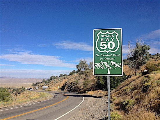
Nevada Highway 50/US Highway 50 stretches for 287 miles from Carson City to Fernley, Nevada, and passes nine towns, two abandoned mining camps, a few gas stations and, according to AAA, “the occasional coyote.” Back in the day, AAA told their membership that it was “totally empty; there are no points of interest,” and motorists were advised ” to not to drive there unless they’re confident of their survival skills.  We don’t recommend it”. In 1986 Life Magazine gave it the title of the “Loneliest Road in America.”

Why in the world would we ignore these warnings?  Why have we committed to the RV lifestyle if not for an occasional risk and the experience to see something totally different?  We are driven to be more than mere tourists and to fully experience the places we venture to see.  The National Parks have been our beacon and guide, and Great Basin National Park was calling us.  We tell everyone that the journey is just as important as the destination. 

See the source image

We arrived in Baker about 2:00.  Just so you know, Baker’s population is 68.  That said, we drove into the parking lot at the Stargazer Motel, and we wondered if we had made a colossal mistake.  The office for the Motel was squished into a small space just off the road, and lodging was not evident.  Given the current COVID-19 advisories, only two people were allowed inside the pint-sized office at one time.  However, behind the mask, co-owner Jake was very warm and welcoming, and gave us the key to room 10. Where was room 10?  We were directed to drive down the street a quarter mile or so just past the unattended, open-24-hours gas station to a small building with a green roof.  The lot behind the old attendant’s building had several campers and other vehicles parked in assigned sites, and we began to wonder what we had set ourselves up for.

Room 10 Right There On The End!

So into Room 10 we went, and we were incredibly surprised!  The room was spotless and we felt like we were in our own little cabin complete with a comfy bed, table and two chairs, small refrigerator, microwave, and actual china dishes and flatware.  The enterprising owners had thoughtfully supplied “green” dish soap, bath wash and shampoo, and a coffee maker and coffee. We felt right at home. 

After unloading the car and some minor unpacking we decided to head up the Wheeler Peak Scenic Drive to the trailhead at 9600 feet. Wheeler Peak, at 12,600 feet is the tallest peak in the Snake Range. About a quarter mile west of town we turned north and began the 7 mile stretch of road that would bring us to the turn off for the Wheeler Peak Scenic Drive or, if we wished, we could continue straight just a bit further into the parking lot for the Lehman Cave Visitors Center and cave itself.

Along the roadway and to the east were private homes whose owners must have a wicked sense of humor and whimsy – they have created “Fence Art” and other artistic treasures for the enjoyment of travelers visiting Great Basin National Park.

Barbara’s Favorite
The Sign Reads “Too Tall Tony”

Driving up Wheeler Peak Scenic Drive was glorious! Every turn in the long and winding, two-lane, 12-mile road, past sagebrush, piñon-juniper and aspen forests, manzanita and mahogany, rewarded us with spectacular views, stretching to the horizon and beyond. It’s rumored that golden eagles enjoy the thermals. 

Mather Overlook was our first stop and we took time to reflect on the contributions of Stephen Mather realizing that there is at a minimum a plaque in his honor in some location in every National Park. Mather was an industrialist and conservationist who, in the early 20th century led a campaign to promote the creation of a unified federal agency to oversee our National Parks. In 1916 Congress directed the Department of the Interior to establish the National Park Service, and in 1917 Mather was asked by President Woodrow Wilson to lead the new agency. He served until 1929, during which time Mather created a professional civil service organization, increased the numbers of parks and national monuments, and established systematic criteria for adding new properties to the federal system. We have been neglectful in not recognizing Stephen Mather before now.

The views from Mather Overlook were incredible.  We ventured on to Wheeler View and we were excited to see the Great Basin glacier, Jeff Davis and Wheeler Peaks.  Amazing!  Back in the car to continue our scenic drive to the parking lot where the Wheeler Peak trailhead begins; the hike to the top a mere 8-mile trek ascending 3,000 feet.  At the parking lot, we were turned back by a Park Ranger who was evacuating the area because of a reported fire.  Disappointed but looking forward to our return the next day we headed back to our motel room.  We stopped at the Great Basin Visitors Center for hiking recommendations before we called it a day.

From Wheeler Overlook
From Mather Overlook
Mountain Monardella
Glacier!

While in Ely we had picked up food for breakfast and lunch, but had not included dinner plans in our shopping. So where does one eat in a town of 68 souls? We had decided to try Kerouac’s Restaurant for dinner, after all it was billed as “an homage to life on the American road.”  The restaurant is the brain child of the motel co-owners Jake and Kate, and conveniently “attached” to the motel itself. It is only open Thursday-Sunday from 4:00pm to 8:00pm, and due to the virus, service was limited to takeout and self-seating.  They offer a complete full bar and the menu selection is limited to pizza, salads and burgers; Barbara was delighted to find roasted brussels sprouts as an option.  The first night we had a bolognese pizza, a large Caesar salad, and brussels sprouts, of course.  We were not disappointed – the food was fresh, from scratch, well-prepared and tasty. We enjoyed dinner on our patio with a glass or 2 of a delightful sangria.

See the source image

We had planned to spend the evening looking at the stars in this incredible dark sky land, but the cloud coverage made it impossible.  Oh, well.  Time for a great sunset and good book before bed.

Up the next morning we had our coffee and breakfast, packed our lunch, and headed up Scenic Drive around 9:00 after determining that the fire from the day before was extinguished and hiking trails were open.  We parked at the Wheeler Peak Campground and found three options:  Sky Islands (the easiest 0.4-mile and wheelchair accessible trail); Alpine Lakes (a 1.5-mile loop through Englemann Spruce and Limber Pine); and Bristlecone Trail (a 2.7-mile alpine trail).  We decided to combine the Forest Trail and the Bristlecone Trail into a 5-mile hike. 

Despite starting our hike at 9,500 feet and ascending to 11,000 feet, the Alpine Lakes Trail was an easy walk. We were in the shadows of some of best forest coverage we have hiked to date. 

The highlight of this Trail was the chance to see two exquisite glacier lakes: Stella Lake and Teresa Lake.  It’s been a long dry Spring and Summer for the region, and the shoreline for each of the lakes was much larger than expected. We imagined that with the snow runoff in early Spring they had been much fuller. Regardless, the waters were crystal clear, the scenery beautiful.

Stella Lake
Barbara Believes This Fellow To Be Part Of The Jay Family. Brian Thinks the Color And Beak Is Just Wrong To Be A Jay. Any Ornithologists Out There?
Alpine Butterfly!
Baby Primrose
Teresa Lake

After a 5-10 minute rest it was time to tackle the Bristlecone Trail.  A ranger we encountered along the way told us that the grove of Bristlecones was not to be missed, but to be forewarned – the trail was a challenging uphill 0.8 of a mile hike. Not to be daunted by this challenge, off we went.  The last quarter-mile over a very rocky and steep path was the most difficult part of he hike – we are happy to report that we got to the top (and back down) in one piece! 

What Could Be Better Than Butterflies Marking Our Path!
Views Along The Hike

According to our National Geographic Guide to National Parks it’s not the Redwoods in California that are amongst the oldest living organisms on the earth – it’s the Bristlecone Pines! These ancient trees thrive where other trees can’t; their contorted limbs have survived thousands of years of damaging storms and timberline conditions – “wind-driven ice, freezing temperatures, and rocky soil.”  One investigator concluded, “adversity begets longevity.” These magnificent trees have dense insect-resistant wood with high resin content that prevents rot.  Bristlecones grow slowly, one branch at a time; their needles living up to 40 years.  Great Basin National Park is home to a magnificent grove of ancient Bristlecone Pines, many over 3000 years old. Some of the trees have even earned names:  Adversity (born 100 b.c.; died 1400 a.d.) and Reluctance to Die, a 3000-year-old tree.  Brian said that the Bristlecones reminded him of larger versions of bonsai trees. It was truly humbling to be walking amongst these beauties.

We hiked back to the parking lot and enjoyed a well-earned lunch before heading back to our room. What a glorious day in the woods of Great Basin National Park! 

Back to Kerouac’s for supper – we shared a burger and some fries and some more of those tasty brussels sprouts as we waited patiently for the night sky to appear. 

And did it ever!  We were dazzled by the Milky Way which Barbara doesn’t remember seeing since she was a child in Colorado.

A Little Too Much Light. Those Dots Are Stars, With A Slight View Of The Milky Way
Milky Way!
Nice Shot Of The Milky Way

We had some nagging light pollution from the gas station so we hopped into the Jeep and headed out to the Baker Archeological site, about a mile out of town and a half-mile down a dirt road.  Millions and millions of stars!  We were wishing we owned a telescope because we were sure we were seeing planets as well.  We weren’t able to locate a comet that we were told was visible in the sky (find the North Star and look downward?).  It didn’t take away from our truly incredible dark night sky experience one little bit.

Big Dipper
Milky Way

Friday morning was checkout. We had breakfast and stopped but a minute at the Lehman Caves Visitors Center and took a short walk to the Caves’ entrance. Guided tours are required for visiting the Caves, but due to the congregant nature of the tours none are being offered in this time of the corona virus.

Entrance To Lehman Caves

So off we went and parked at the trailhead for the Baker Creek trails.  We had three trails to choose from:  Baker Creek to Baker Lake; South Fork Baker Creek loop; or Timber Creek. 

The Park Ranger had recommended the fairly easy “through the forest” South Fork Baker Creek Loop.  We mistakenly took the Baker Creek to Baker Lake Trail despite seeing a posted warning to avoid the trail because a hawk had attacked a hiker the day before.

We were prepared (???) to face an aggressive protective nesting hawk, but not the literally breath-robbing and exhausting uphill 3-mile trek starting at an elevation of 2,600 feet, and ending at nearly 8,000 feet!  We turned back after about an hour, realizing our mistake and exhaustedly headed back to the car for a final farewell to Great Basin National Park.  Barbara finished the day with a good feet-soaking in frigid Baker Creek.

Columbian Monkshood
Streambank Wild Hollyhock
Dwarf Checkerbloom

Driving south on highway 93 and heading back to Williams, we marveled at the incredible beauty along this stretch of endless straight-as-an-arrow highway where mountains seem to just rise up out of the desert floor.

Miles and miles of unoccupied land stretch to endless horizons.  The sweeping vistas and full complement of colors ranging from purple to pink and orange are breathtaking on this forever highway. 

We were driving along the Great Basin!  We’d travel it all over again in a heartbeat!

Barbara and Brian

BETTER THE 2nd TIME AROUND?

May-July, 2020

Last July we had the opportunity to visit the Petrified Forest National Park and the Painted Desert. Last August we spent time at Sunset Crater Volcano and Wupatki National Monuments, and explored in depth, from the North, South, East and West, Grand Canyon National Park. These are all within fairly easy reach of our 2020 summer home due to the coronavirus in Williams. If we loved ’em the first time how could we pass up, at least, one “next” visit?

Wonder what we’ll see and how we’ll feel about these attractions without the “oh wow” factor of the first time around?

See the source image
Underappreciated!

“It is the middle ground between light and shadow, between science and superstition, and it lies between the pit of man’s fears and the summit of his knowledge.  This is the dimension of imagination.  It is an area which we call the Twilight Zone.” 

Imagine if you will, what it might be like to be blindfolded and driven to a landscape that defies anything you have ever seen.  That’s what it’s like every time you set eyes on the Petrified Forest National Park in northeastern Arizona.  The park covers nearly 230 square miles of desert shrub steppe as well as the highly eroded and colorful badlands called the Painted Desert (by the way – why isn’t the Painted Desert a National Park in its own right?).

See the source image

We decided to experience this amazing and beautiful National Park on a hot, dry June day. As we pulled into the Park we noticed that the temperature was approaching 100 degrees Fahrenheit, so we decided to limit our hikes to loops, like the Crystal Forest, that were less than a mile.  There is no merciful shade from exposure to the sun once on any of the trails.

The Visitors Center was closed but the Park Ranger at the gate gave us a handy travel guide.  It’s hard to imagine that there are more than 400 species of plants on this dry and arid landscape.

Invasion Of The Body Snatchers?

And it’s unthinkable that anything like pronghorns, coyotes and bobcats make their home in this unforgiving climate.  We did spot an occasional lizard, but snakes and other reptiles were cooling their jets waiting for the temperatures to fall to something more reasonable – they only come out at night?

How did these trees become the remarkable beauties we see today?  What we learned was that when the trees died, they fell over and were rapidly buried in a river channel or floodplain under layers of mud, sand and gravel. Over time the fossilization process completed, creating petrified wood. While the logs may still resemble trees, their internal structure has changed due to water saturation of the tree’s fibrous tissue and a lack of oxygen from being buried. Without oxygen the trees don’t deteriorate.  The soil in the Park is mostly volcanic ash and when mixed with water becomes silicic acid, which eventually enters waterlogged trees and interacts chemically with the wood. Silicic acid becomes silica and replaces the original fibrous tissue; over time you end up with a silica replica of the tree. Traces of other elements like iron oxide combine with the silica to create the incredible array of colors in the petrified wood.   According to the Park’s paleontologist, the process actually happens over “a few 10,000’s of years” – fairly quickly geologically speaking.  Over time and with the pressure exerted on the silica replica by being buried, the petrified wood becomes solid quartz. 

The gigantic petrified trees that had been buried over time were unearthed by tectonic forces, erosion, water and the endless winds.

What were the original trees that we now know as the Petrified Forest?  Archeologists believe much of the park’s wood is from an extinct conifer tree (Woodworthia) while other trees found in the northern part of the park represent at least nine species of fossil trees which are all extinct.  This park is a paleontologist’s dream; over 600 archeological sites have revealed an unbelievable treasure trove of ancient plants, giant reptiles, early dinosaurs, and petroglyphs.

The petrified trees appear to have been sliced into segments by the Park Service.  Not true. The park ranger we met on our hike said it happens naturally over very long periods of time.   It has to do with how these trees got to their present location.  The forces of geology started the uplift of the Colorado Plateau, and the park went from deeply buried to being raised more than one mile.  At its high point continuous erosion exposed old rocks and their fossils: the petrified logs.  The movement of the land caused the logs to break.  And the inner surfaces where they have broken are flat because quartz doesn’t break neatly across its crystal faces.  Instead the quartz snaps across the log’s shortest area.  Cutting these logs would be a pretty arduous task requiring a diamond saw and plenty of time. 

The Painted Desert we can view may have been absorbed into the Petrified Forest National Park, but it is really a broad region of rocky badlands encompassing more than 93,500 acres – stretching to the southeast from (just about) the eastern edge of the Grand Canyon to the small section we visited today. Some say its like being transported into a painting.

Millenniums, the uplift of the Colorado Plateau, earthquakes, tectonic plates in motion, the effect of the mighty Colorado River carving its way through an ever-deepening canyon, and volcanic activity defined the geography we see today in Northern Arizona. Grand Canyon National Park may be (?) the most dramatic and picturesque of the area’s attractions, but Sunset Crater Volcano and Wupatki National Monuments have a unique place in history for 2 reasons. Sunset Crater Volcano is a dormant volcano whose last eruption was in 1085. Those eruptions created an expansive and impressive array of lava fields that rival Craters of the Moon National Monument in Idaho. Secondly, there are the ruins of 5 Wupatki pueblos in this (now) desolate barren land. How the Wupatki peoples survived, and then why they left are still questions being answered.

The wonderful scenery starts soon after entering the Sunset Crater Volcano National Monument property.

Views Of The San Francisco Peaks

Sunset Crater Volcano may be the “big daddy” inside the Monument, but it is not the only volcano that helped shape the region.

Across the street from the A’a Lava Field is the Lenox Crater Trail, a moderate 1.6-mile loop trail that ascends through ponderosa pine forest before reaching a summit that overlooks the Lenox Lava Field and has a spectacular view of the San Francisco Peaks.

See the source image
Lenox Lava Field
San Francisco Peaks In View
Apache Plume

Following our descent from the Lennox Crater Trail it was a brief walk to hike the short Bonito Vista and Lava Flow Trails.

Mexican Hens (Echeveria)
Sparassidaceae
Sunset Crater Volcano From The Lava Flow Trail
Silverleaf Nightshade

We stopped for lunch at the Visitors Center and a bluejay was hanging around probably looking for a quick bite to eat – perfect for a picture. But the rascal was teasing me all the while and all he’d give me was a profile in the shadows of a tree.

Doesn’t Quite Look Real – Does It?

We felt as if we had done a good job exploring the Wupatki pueblos, but there was one hike of interest in the National Monument…the Doney Mountain Crater Trail – hiking on another dormant volcano!

Vista View- The Clouds Made The Picture

What more can be said about the beauty of the Grand Canyon? We have stood in astonishment of the canyon, hiked a portion of the Kaibab and Bright Angel Trails, been at the South Rim for sunup and sunset, and marveled at the grandeur of Mother Nature’s handiwork.

As is said: “a picture is worth a thousand words.”

This Little Guy Welcomed Us To Our Next Visit At The Grand Canyon
Sometimes The Light Is Just Right!
See The Colorado River?
Duck Rock
Apache Plume
Desert View Tower Stands At The East Entrance To Grand Canyon National Park
The Mighty Colorado River

So to answer the original question way back so many pictures ago, we’ll use what Barbara calls Brian’s way of answering a question – with other questions! Does anyone ever forget their first love? Does anyone ever forget the birth of their first child or grandchild? Does anyone ever forget the address or phone number of their childhood home? Not to diminish one iota what may follow – the places you live, the loves of your life, children and grandchildren – but, well, there was a first time and it will always hold a special place in our memory and heart.

We had a chance to spend more time at Petrified Forest National Park and Painted Desert, as well as Sunset Crater and Wupatki National Monuments than the first time around. In Brian’s opinion the light was better and there was no hazy interference from fires at the North Rim for pictures of our visits to the South Rim of Grand Canyon National Park.

Better this time around can’t really be answered. We both still had “ain’t-this-amazing-awe-inspired- stop-and-stare-soak-it-in” moments just like our first visits. Becoming students of and appreciating more fully these incredible treasures might be a better way of encapsulating our experience.

Barbara and Brian

CAR SHOW

June, 2020

Are you tired of reading about our hikes, usual and unusual places we visit, and the things we do on this adventure of ours? Tired of landscapes, beautiful vistas, endless skies, hiking trails, lizards, snakes, and flowers? Well hold on to your hat…it’s time for the

See the source image

Hosted by American Legion Cordova Post 13, the weekend of June 12-13 hundreds of vintage cars cruised town and lined the street. Barbara and I enjoyed walking around town seeing the beautifully and lovingly restored, modified and mint classic cars, and talking with the owners about their vehicles. Later on Saturday there was a “slow burn” cavalcade through town up and down Main Street, the old Route 66. Many of the cars we saw earlier in the day drove by, there were more than a few burn outs, and the socially-distanced crowd was entertained with a nice spectacle.

For you vintage car fans we hope you enjoy the pictures, and maybe they’ll bring back some memories?

Little Duce Coupe?
Ford Edsel era 1958-1960
I Don’t Believe Lime Green Was A Stock Color
1928 Model A
Is This A Tank Or A Chopped And Channeled Olds?
Studebaker
Rolls Royce?
1941 Willys Coupe
Oh What Stories That Back Seat Could Tell!
Brian Owned A ’67 Chevelle SS – Green With The Racing Strips
Great Line-Up Of Classics
Dig That Paint Job!

Barbara and Brian

SEDONA REDUX

See the source image

May – JuLY, 2020

There are so many incredible places to experience in Arizona, it’s difficult to say that one place is our favorite.  Not that anyone needs to single out one particular place, but here in North Central Arizona we are drawn repeatedly to the beauty that is uniquely Sedona.  With great anticipation, we looked forward to the many opportunities to hike the trails and explore the incredible red rocks that are the geography of this remarkable place. Some jaded individuals might say “well, if you’ve seen one red rock, you’ve seen them all.”  We challenge those who express this somewhat pejorative view to visit Sedona, and if still not convinced perhaps they ought to try Sedona at sunrise or sunset.  The expansive array and diversity of colors, patterns, shadows and shapes are astounding.  The ever-changing red sandstone dazzles the eye with every imaginable shade of color so famously captured in paintings by famous southwest artists like Georgia O’Keefe.  When Ms. Okeefe’s paintings were first shown in museums, people who had never been west of the Mississippi were startled by the purples, blues, reds and oranges that predominated her landscapes.  The uninitiated refused to believe that these colors really exist in nature, and said she had a fanciful imagination because no place really looks like that.  But it does.

Bell Rock
Century Plant – A Species Of Agave
Bell Rock
Courthouse Rock

We have hiked many trails in Sedona, and our favorite is the popular West Fork Trail in Oak Creek Canyon – several miles north of town. We had tried to hike this trail during March, 2019; however, the spring snow melt run-off had the water in the Creek too high and running too fast to make even the initial crossing doable.  

A handful of parking places this visit meant fewer hikers to share the trail with, and it allowed us to have a leisurely afternoon zigzagging back and forth across Oak Creek – there are 13 crossings in total. We explored this incredible canyon with its sheer cliffs, remarkable overhangs and dense forest.  It’s a place for the senses:  to breathe deeply and enjoy the earthy smells of evergreens and all the wildflowers; the crunch underfoot of pine needles as you travel, and the voices of children and families playing in the creek; the warmth of the sun and the bluest of skies.  We were surprised to find Columbine flowers that were three feet tall.  They didn’t look like others we had seen in Colorado and New Mexico.  We heard the songs of bluejays.  We hiked for nearly two hours and decided to get back to our car before dusk.  We vowed to return to explore another trail in Oak Creek Canyon another day. 

Golden Columbine
Red Veined Darter

Rated as one of the best in and around Sedona, Devils Bridge Trail is a “moderate” 4.6 mile out and back hike with an elevation change of 650 feet. There are 2 things that are not mentioned when googling the trail: 1 – the trailhead for Devils Bridge is 1.5 miles from the parking lot, and the trail to the summit is 0.8 miles. That first 1.5 miles is an easy hike with mostly sand underfoot, but there is exposure to the strong rays of the sun; i.e., there is no shade. 2 – while the trail itself winds its way up in a mostly easy ascent, the last 200 yards or so are severely steep scrambles up slickrock; the first 100 yards brought us to a mesa overlooking the red rocks to the north and west, and the next 100-yard climb reaches the summit.

Our descent was much more difficult than the ascent – simply, the sun’s rays and heat took it out of us. Imagine too that slickrock is not very forgiving, and, Brian’s leg was not quite ready to bend as needed to make his way down without jeopardy. But something curious happened in this age of the corona virus – men and women of various ethnic and racial backgrounds extended a helping hand to the old man and the descent became doable.

By the time we reached the trailhead exhaustion had started to settle in and we had another 1.5 miles with 100% exposure ahead of us before returning to our Jeep. 2 young men we had met on the trail had driven to the trailhead in a high clearance 4-wheel drive pickup, and were heading out just after we started on our arduous journey. We asked for and were given a ride back to the parking lot, learning that one of the young men had graduated from NAU a year ago and was waiting to take the fireman’s qualifying test in a few months and that the other had just graduated himself and was uncertain what his future held.

We are most grateful to those that gave us help and encouragement. What’s that phrase? We’ll get through this thing together – never more cogent than our hike to Devils Bridge.

Nature’s Resting Place Before The Last “Killer” 200 Yards Up
Devils Bridge

There’s a choice of 2 hikes Brian says to Barbara: “one that’s shorter but much more challenging, and one that’s longer but more beautiful.” Which would you prefer he asks? Without needing more than a second or 2 to respond she says: “let’s put ourselves to the test today and give Cathedral Rock a go.”

Cathedral Rock Trail is a 2 mile out and back hike that is relatively easy for the first 3/4 mile to the base of Cathedral Rock, and it ends with a 450-foot elevation climb up and over slick rock for the last quarter mile.

Cathedral Rock
Working On His Tan?
See The Hikers?

We got to a point along the trail and realized that the last ascent up slick rock was more challenging than anticipated. Brian choose to stay behind, but Barbara saw Cathedral Rock as something to be conquered and made her way to the top!

The Chapel of the Holy Cross sits high atop the red rocks of Sedona, Arizona. A local rancher and sculptor Marguerite Brunswig Staude was so inspired after seeing the Empire State Building that she personally designed the Chapel and commissioned its construction. Brian remarked that he’d love to ask her about her inspiration. The Chapel was completed in 1956, and is a beautiful landmark befitting this glorious region.

View of Cathedral Rock From The Chapel
See the source image
Courthouse and Bell Rock From The Chapel
Cane Cholla In Bloom
Tree Cholla Blossom
Cathedral Rock

Remember Barbara choosing a shorter more challenging hike on the Cathedral Rock trail over a longer but more beautiful trail? Brian couldn’t leave out that longer hike…the Fay Canyon trail, a  2.6 mile out and back pretty much level trail that, All Trails claimed, featured a waterfall, an arch, and a summit climb/scramble at the end of the trail. This should have been a nice easy stroll, but the temperature was well into the 90’s, and even with tree cover and shade it became a tougher hike than expected. Don’t get us wrong it was not nearly as exhausting as Devils Bridge Trail.

We couldn’t find the tributary trails for either the arch nor the waterfall, and asked for help from hikers along the way. The cut off for the arch was near the beginning of the hike everyone said, but it wasn’t marked and after a bit of a search we gave up. Curiously no one could confirm that there was ever a waterfall along this trail…oh well, a peasant enough hike on a hot day.

Love That Lone Tree On Top Of The Rock
Butterfly Weed
Does That Look Like A Face To You?
Arizona Thistle
You Wanna Scramble Up There?

Arriving at the trailhead for the Broken Arrow Trail we found out that there are actually two trails called Broken Arrow that run more or less parallel to each other: a narrow path for hikers and mountain bikers and a wide unimproved “road” for off-road and 4-wheel drive, high clearance vehicles. While we were hiking to the end of “our” Broken Arrow Trail we saw several of the local Jeep Tours giving their passengers a most interesting ride. Oh yeah – Broken Arrow Trail ends at Chicken Point.

See the source image

The Broken Arrow Trail is a moderate 3.4 mile hike through shaded pine forest, past a sink hole known for its bat colony during the late spring/summer/early fall months, and features easy scrambles over slick rock, and some of the best views in Sedona.

See the source image
Dakota Mock Vervain or Prairie Verbena
Submarine Rock
View From Chicken Point

We might have forgotten to mention that Barbara’s sisters, Joy and Meg, came for a visit and showing off the beauty of Sedona seemed to be the right thing to do…or maybe not!

Sedona Beauty

Sedona is a hiker’s paradise, and we have been fortunate to be able to explore some of the more “shouldn’t be missed” trails. Many consider Sedona a town for vacationers and tourists, but that whole scene is not central to enjoying the outdoor beauty ever associated with the area. If visiting, please come into the area by taking exit 298 off of Interstate 17 and heading North on Red Rock Scenic Byway – AZ Route 179 towards Sedona. The trip will take your breath away – it’s even better at sunrise or sunset.

Barbara and Brian

TRAILING ABOUT FLAGSTAFF

See the source image

April – June, 2020

Flagstaff is 35 miles east of Williams along Interstate 40, and is home to the Northern Arizona University Lumberjacks, the Lowell Observatory (its been around since 1894 and from there in 1930 Clyde Thombaugh was the first to see Pluto!), the Arizona Snowbowl (learn to ski AZ!) and, at 12,633 feet, the State’s highest point, Humphreys Peak. As of 2019, the City’s estimated population was 75,038 with a metropolitan area estimated at 139,09 lives. Being so close to Williams, Flagstaff feels like an extension of our summer of 2020 campground.

See the source image
I’m A Lumberjack And I’m OK

Flagstaff is within and surrounded by the Coconino National Forest. Hiking trails are easy to find and range from an easy loop walkabout with little elevation change to several hikes not for the fainthearted – 20 miles out and back with an elevation gain of more than 3,300 feet. Some hikes are part of the City Park and Recreation Department, some maintained by the National Park Service, and some in the Kachina Wilderness are still rustic. Hiking trails traverse Ponderosa Pine and Aspen forest, volcanic rock and/or redstone.

After a volcanic explosion, a hollowed out crater or caldera usually forms at the apex of the volcano’s cone. Occasionally though the side of the cone, rather than the top, blows out. Scientists estimate that Red Mountain last erupted about 740,000 years ago, when a good portion of the side of the cone was blown out. North of Flagstaff along AZ Highway 180 is the Red Mountain Trail.

Red Mountain

The Red Mountain Trail is a 2.7 mile out and back hike with little elevation gain. Glorious views of the San Francisco Peaks accompanied us for the first mile or so on an easy walk passing through prairie and then pine forest before the trail became very interesting as we entered into towering red rock formations and volcanic rock. There’s a ladder to climb before entering into a pocket canyon that gives access to hiking amongst the red rock . After exploring for a while we stopped under an old, old tree for a great picnic lunch.

In The Distance And Still Snow Covered – The San Francisco Peaks – Named In Honor Of St. Francis of Assisi By The Spanish Friars That Settled The Area In The 1620s
The Western Sky Continues To Be Amazing!
Forget-Me-Not
Barbara Loved This Cloud Formation

The Mount Elden hiking area is a little northeast of town, and from the trailhead there are 5 trails to consider completing.

The Elden Lookout, Heart, Sunset and Pipeline trails are for the more experienced hiker, each with elevation gains of 1,500 feet or more and length in excess of 5-8 miles with steep grades and switchbacks. Fatmans Loop Trail is the 5th trail, and is rated as a moderate out and back 2.4 mile hike suited for most hikers; i.e., us old folks.

Fatmans Loop Trail starts out benign enough with an easy walk through Pine and Oak Forest, but at about 3/4 mile into the hike things take a turn. From that point until the summit, oh, in about a half mile, it is a scramble up a rocky path and at times up and over small boulders. Since we had chosen the counter clockwise route (who knew?) the first half mile of our descent became very steep and on loose rock and sand. Not much of a problem for Barbara, but with Brian still rehabbing his bum right quad tendon he had to figure out a different way down. Ever heard of the sit and slide hiking technique?

Ask Barbara About The Pinecones
Do We Have to Practice Social Distancing Too?
Take A Good look – This Is One Great Tree

Other than Brian’s dirty britches and calves we made our descent without incident. Heading back to the trailhead a family that had passed us earlier in the hike was just hanging out on the trail and staring into the brush. They reported that a snake had just crossed their path. We just had to take a look and found a rather handsome red/orange, white and black banded snake sliding along (sorry Elyssa).

I Gotta Get Out Of Here!
Maybe I Can Hide Around The Corner?
Damn – Found Me

Now we didn’t know what kind of reptile we were encountering, which simply means whether or not it would bite and if so was it poisonous? As Brian kept getting closer and closer to take pictures we tried to remember how to tell a venomous coral snake from a benign milk snake – both have bright colorful rings. Isn’t there a rhyme about it? Oh yeah…”Red touch black, safe for Jack. Red touches yellow, kills a fellow.” Or at least we thought that was correct, and figured since there was no yellow banding we were safe.

We Forgot Snakes Can Climb

And then just before getting back to our Jeep this fellow crossed our path. We were sure it was to wish us bon voyage from Fatmans Loop Trail…

Hope You Had A Nice Hike – Hissing You Already!

The Northern Sinaugua peoples occupied this region over 1000 years ago and in the Picture Canyon Natural and Cultural Reserve the evidence of their residency can be found in the nearly 800 petroglyphs etched onto the Canyon walls and nearby boulders.  The canyon is a unique geologic find as well, because it was formed by the gap between two lava flows along the Rio de Flag (Flagstaff River) east of the City. How strange is it that the lava flows didn’t merge?

Because of the archeology associated with the Northern Sinaugua peoples and its geological uniqueness Picture Canyon was added to the National Register of Historic Places in 2008.

The hike is a fairly easy ramble through wetlands and forest. There are 2 well maintained hiking paths, one that takes the hiker to the base of a small waterfall, well into the canyon and past the majority of petroglyphs, and a 2-3 mile loop trail we chose.

Banana Yucca
Check Out The Ears On This Cutie – We Think This Is Albert’s Squirrel

We happened to stop while crossing a short wooden bridge to admire the view down river, and, well, this fella just happened to be hanging out in the water!

Not Sure Why The Blue Aura Around The Snake And The Rock – Thoughts?

Then a little further on Brian almost stepped on a milk snake, which coiled up as if to strike. He must have really startled the snake – milk snakes are not known to be very aggressive at all.

“…Red Touches black…”

And to cap the day off, a rather long (we believe it to be) gopher snake was making its way through the brush, and just off of our path.

Flagstaff has any number of very nice urban parks, hiking paths and bike trails.

Buffalo Park is a 2.2 mile loop trail. The path is gravel, and if hiking the trail in a clockwise fashion the first half mile is of moderate difficulty beginning with a rather steep drop in elevation followed by a challenging incline – the remainder of the trail is flat. Cutting through the Park and a half mile long is part of the Arizona and Lower Oldham Trails, which if followed will take the hiker to the trailhead of several more hikes in the Northern Arizona wilderness.

Bet You Can’t See Me
Short Tailed Lizard?
Believe It Or Not, Those Tater Tot Looking Things Will Form A Pine Cone For This Pitch Pine Tree
Another Pine Cone In The Making
Coastal Prickly Pear Cactus Bloom
Not Sure What This Fellow Is – Any Ornithologists Out There?

Sandys Canyon Trail starts out by skirting the rim of Walnut Canyon, a scenic rift in the same layers of rock that form the upper cliffs of the Grand Canyon.

The trail heads north from the trailhead following the Walnut Canyon Rim for a short distance before it drops down Sandys Canyon into the main gorge. Sandys Canyon Trail then continues along the Walnut Canyon floor on an old jeep track to an intersection with the Arizona Trail (guess we could have gotten here from Buffalo Park?). During our 3-mile hike we stopped for a picnic lunch amongst the deep red hues of petrified Permian Age sand dunes.

Drop Into The Canyon
Petrified Sand Dune?

At 12,635 feet (2.39 miles above sea level!) Humphreys Peak is the highest point in Arizona. From its trailhead at 9292 feet (1.76 miles above sea level!) there’s a 10 mile trail with an elevation change of 3,343 feet (just about 2/3 of a mile!) that will take you to the top, which, of course, means a steep 10 mile descent back to the trailhead. The trailhead is at the base of Arizona’s best ski area (Arizona, ski area? go figure) – Snowbowl (of course that’s its name).

See the source image

About 9 miles west of downtown Flagstaff we found a great drive through the pine and aspen forest of the San Francisco Peaks up the mountainside 3,000 feet to Snowbowl. Turning left at the entrance we found Humphreys Peak trailhead. The view from there west is pretty nice.

So How Far Can You See?

We didn’t, and probably couldn’t while Brian’s in rehab, hike ourselves to the top of Humphreys Peak. It certainly would be fun to give it a try down the road.

After checking out the Humphreys Peak trail from its base we found a parking lot just across the road, which lead us to the trailhead for the Kachina Peaks Trail. Most hikes in the San Francisco Peaks region head to a summit, but not the Kachina Peaks Trail. This trail winds its way 10.2 miles through beautiful Aspen, Pine and Fern Forest, and for the most part is a great hike for anyone -families included. Hike as much or as little of the trail as you want. This is one of Barbara’s all-time favorite hikes – just beautiful.

Golden Alexander
Prairie Fleabane
You All Come Back Now, Hear?

It seems that the more we hike, the more we find to enjoy in nature and the more we find ourselves appreciative of this time in our lives. The days we spend discovering new trails, the sights we see along the way, and the feeling of accomplishment in meeting nature’s challenges (and knowing our limits) brings us a tired smile at the end of the day. Turns out we found Flagstaff is one of those places not to be missed for some great hiking adventures.

Barbara and Brian

ARIZONA CURIOSITIES

April – May, 2020

Williams, Arizona was the last city along the Mother Road to be by-passed as Interstate 40 headed west on its way to the City of Angels. Many of the oddities that were once diversions and rest stops for the weary traveling from “Chicago to LA” became ghost towns, signage fronting empty patches of dirt and decaying buildings or too far off of the highway to any longer be of interest to the travelers of today. Some of those oddities remain, and for us to seek them out made for great adventure.

Image result for burma shave signs pictures

Burma-Shave was an American brand of brushless shaving cream, and famous for its advertising gimmick of posting humorous rhyming poems on highway roadside signs. Six consecutive small signs would be posted sequentially along the edge of the highway, and spaced for reading by passing motorists. The last sign was always the name of the product. The company was sold in 1963, and the use of the roadside signs formally ended; however, and if you stay on Route 66 between Seligman and Hackberry, some folks with a sense of keeping history alive have posted signs in keeping the spirit of the Burma Shave signs alive.

Burma Shave Roadside Signs For Sale

As we headed westbound along the Mother Road our first planned stop was Seligman, Arizona to have lunch at Delgadillo’s Snow Cap. Perhaps nothing more than a root beer stand in the glory days of Route 66 this drive-in has now become a must stop and icon along the route. Delgadillo’s is a homage to what hungry travelers wanting to feed a family would expect to find while motoring west along Route 66. Sure, there is a screened-in porch for indoor seating as well as a few tables in the “graveyard ’round back,” but taking a good look around we could just imagine that in its day car hops were busy taking orders and delivering food. We’re sure that “snow cap” refers to ice cream creations. Delgadillo’s menu includes the usual burger and fries, onion rings and various takes on a hot dog as well as a dose of whimsy and their their famous cheeseburger with cheese! Somehow though we wanted to shy away from dead chicken – whatever it is and however it is prepared!

A quick walk around while we waited for our food and we came to appreciate the owners’ dedication to commemorating the history of what has been, their welcoming nature and sense of humor, and the preservation of…well they do say that a picture is worth a thousand words.

Isn’t Root Beer Always Supposed To Be Creamy?
Yup – The Sign Does Say “Sorry We’re Open!” How About “Sorry We’re Drinking?”
“Dead Chicken?”
Anything Remind You Of Rotary International?

2 absolutely first-class green chili cheeseburgers with cheese, onion rings and sweet potato fries, and a chocolate malt later, with our bellies full and a smile we were on our way to our next stop. By the way, if in the neighborhood we’d stop again and just may have to try the dead chicken!

The longest continuous stretch of the Old Route 66 that still remains today is 86 miles long and runs from Seligman to Kingman, Arizona. 60 miles west of Seligman is what is described as one of the kitschiest stops on the Mother Road. The Hackberry General Store is located in the former mining town of Hackberry, Arizona (right?), and is bypassed by many Route 66 travelers, oftentimes because they simply blink and miss it. There is no signage and the store is isolated in the middle of the desert. We were looking for it and, but for a hard hit on the brakes, almost scooted on by.

At one time a lifeblood for the miners who came to the area to look for silver that had been found in the surrounding hills, the store is really all that remains of the community – it’s now a ghost town. Self proclaimed the “Mother Lode of Mother Road Memorabilia,” the Hackberry General Store is packed wall to wall with historic signs and artifacts, and the exterior of the general store is just as quirky. Historic Pegasus gas pumps, rusted-over Model A’s from the early 20th century, and a small vehicle boneyard are scattered across the store’s façade.

The owner was quick to engage us and was eager to know where we were from, and noted that his prices were the best in the area and that we should buy our souvenirs from him. His conversation quickly deteriorated into extreme right-wing conspiracy theory rhetoric, and when we didn’t agree the friendliness disappeared. Honestly, the place reminded Brian of the pawn shop in “Pulp Fiction.” We beat feet asap.

We had a hard time believing that in the middle of the Mohave Desert, about 30 miles north of Kingman and on the way to Las Vegas on Arizona Highway 93 someone built a place called Santa’s Land, and actually incorporated the area as Santa Claus, Arizona. It does occasionally snow in Kingman, but the city averages over 290 days of sunshine annually, and the last 2 substantial snowfalls (that paralyzed the area) occurred in February, 2019, and 1932! So why Santa’s Land?

Nina Talbot and her husband considered themselves the “best of the best” real estate brokers, moved from California and founded Santa Claus, Arizona, in 1937 in an attempt to attract buyers to the desert location. Santa’s Land featured Christmas-themed buildings, and visiting children could meet Santa Claus at any day of the year. The town’s post office became very popular in December as children and parents could receive mail postmarked with the town’s name. The town did in fact become a popular tourist destination, however no one ever bought land there, and the only people living there were the ones working in the town. Failing to see how she would make her real estate business profitable, and with the town in decline, Talbot sold Santa Claus in 1949, having failed in her attempt to convince people to move to the desert. While popularity of the restaurant (Duncan Hines (!) loved the place), a published story by Robert Heinlein of Mrs. Claus’ gourmet meals, and movie actress Jane Russel hosting a dinner party there in the 1970’s kept the location “alive” for a while thereafter, the site is now a ghost town best-suited for the rattlesnakes that have found a home in the remains of dilapidated buildings.

Santa’s Land Circa 2020

But then turn around and sometimes beauty is just waiting…

Looking East From Santa’s Land

We were pretty disappointed to have come all this way to find even less than Atlas Obscura had described. But as we were heading back towards Kingman and ultimately to our campground in Williams, Barbara was fooling around with her phone and discovered that a short ride from Santa Claus was the ghost town of Chloride. Chloride was at one time another of the thriving mining communities within the region with 75 mines and 5,000 residents (yeah – there was silver, gold, and turquoise in them thar hills!). By 1940 the mines had closed and the town had been mostly abandoned. Today there are only 20 occupied homes; some host a wonderfully bizarre collection of junk art, and for the adventuresome willing to take a short ride on unimproved dirt paths into the hills, there is the reward of a display of giant murals painted on the rock face. What a find!

A week or so later we were having lunch with Harvey and Marilyn Baker. Harvey was Brian’s softball coach and we’ve become friendly. The Bakers are not quite as nomadic as we are presently, but over the course of a 10-years span of time, they visited every state save the deep south, and they have seen a thing or 2 along the way. Harvey suggested that we would like Oatman, Arizona. It’s another old (gold) mining ghost town tourist trap, but the novelty of burros freely roaming the dusty streets make it a must see. The burros are the decedents of those used in the mining operation, which began in the 19th century and was bust by 1942.

Perhaps the best part of our adventure to Oatman was the road into town…a true mountain road, barely 2 lanes with few pull offs if you have car trouble or want to take a picture, multiple switchbacks, and a sharp decline into town. The scenery was tops…

Heading To Oatman

….it’s pretty easy to find a place to park once in town, and the standard touristy thing to do is to buy a bag of burro food for $1 and feed the gal-darned things as you walk up and down Main Street. Otherwise one might support the locals and stop for a beer or have a burger in one of the establishments, buy a souvenir, a piece of artwork, indulge your internal rock hound or just be amused by the sites and posted signs all over town.

Spending his teen years in Chicago, Brian heard the WGN TV evening news weatherman, Harry Volkman, report on the temperature in Bullhead City, Arizona daily – Harry believed it to be the hottest place in the US. Now Bullhead City is only 23.5 miles from Oatman, and Brian had to see the place for himself. Since we were hungry what could be a more perfect stop for a late lunch?

Oatman had their farewell committee waiting as we left town on our way to Bullhead City.

Yo Tourista, Anything To Declare?

It may not be the consistently hottest place in the US, but as we entered Bullhead City proper the thermometer was topping out at 100 degrees Fahrenheit.

See the source image

Brian had thought this would be a sleepy small town on the Colorado River, but there are well over 40,000 people living in the incorporated City, and with Laughlin, Nevada right across the Colorado River, Bullhead City was one busy place. We had a fabulous meal at local Mexican restaurant, and as we drove through town noticed that the River was packed with folks on jet skis. We made a pledge to return and take advantage of a day on the River, and maybe, just maybe place a bet or 2 at the casinos in Laughlin!

See the source image
Laughlin At Night

Several of the recommended unusual places we wished to visit are on lands of the Navajo Nation; they will be on our list for the future. The infection rate and severity of coronavirus amongst the Navajo Peoples has resulted in their lands being shut down to visitors. We can only wish them well at this time in their fight for health.

Barbara and Brian

COCONINO NATIONAL FOREST

See the source image

April – May, 2020

The western most entry into the Coconino National Forest is a scant 2-3 miles east along Interstate 40 from Williams, Arizona, and is nestled between several other national forests.  While the forest climbs to alpine tundra heights north of Flagstaff, and it is possibly best-known for the red rock formations of Sedona. In this section of the forest, Ponderosa Pines dominate the landscape, ATV’s are challenged to see how much red dust can be kicked up while navigating seemingly endless trails best suited for that mode of transportation, trailheads for hikers lead to seasonal waterfalls, naturally occurring water storage tanks are nestled amongst the rocks and a “rim walk” looking down on Sycamore Canyon. Look carefully and see osprey and their nests, as well as an occasional bald eagle both soaring on the thermals or fishing the deep fresh water lakes. Recreational opportunities abound if one doesn’t mind a little (?) red dust to get there.  We found out we cleaned up just fine.

Just in case here are directions to this bit of wilderness – take exit 167 off of Interstate 40, head south about 4 miles and cross over the railroad tracks, turn back east for 6-8 miles, and depending on where you’re heading pick up the forest road that takes you to your destination.

Described as an easy 2.5 mile hike around the lake, Dogtown Lake became our first adventure in the forest.  Guess we weren’t the only ones to see the chance on a beautiful day to enjoy the lake; as we approached, the roadway and parking areas were packed with cars.

DSC08884 (4)
Beginning Our Hike – Dogtown Lake
DSC08885 (2)
DSC08886 (2)
DSC08887 (2)

The Coconino National Forest presents endless recreational possibilities, but the real character of this region of the forest is defined by Sycamore Canyon. At 21 miles long, averaging a mile across, and totaling 56,000 acres Sycamore Canyon is the second largest canyon in Arizona – only the Grand Canyon is larger.

Finding the Rim Trail trailhead and after a quick study of a conveniently posted map we took off planning to hike from the “observation point” to the waterfall. From the map it looked like the hike should have only been a couple of miles; however, and after a good hour we realized that either we didn’t know how to read the map’s legend or the map was wrong. Nice easy hike – no waterfall though.

View From “Observation Point” Into Sycamore Canyon
Say Hello To Our Little Friend
Scarlet Hedgehog Cactus

Not to be denied we drove down a different forest road, and on our second trip into the Coconino National Forest found the Sycamore Falls trailhead; from there it was only a short hike to the falls. Unfortunately the waterfall is fed by winter run-off which is long gone. But dang it, we found where the waterfall would be if it could be!

Leading To The Falls?
Waterfall Retention Pool…Imagine Water Falling Over The Edge
Yeah – The Rockface Is Really This Colorful

Know what a forest tank is? Nah – neither did we, but the Pomeroy Tanks were noted as a featured area of the Sycamore Canyon’s Rim Trail. Forest tanks are permanent deep pools of clear water. Situated beneath black lava cliffs and other jagged formations the Pomeroy Tanks provide water 365 for the wildlife that inhabit the Canyon.

Without a doubt this was our favorite hike in Sycamore Canyon.

One Of The Pomeroy Tanks
Brian’s Favorite Picture
Wild Iris

Sycamore Point is literally at the end of the road, and if we were recommending one stop this would be it. Walk a short 50 yards or so from the parking area and the views are spectacular!

We were used to cruising along the forest roads of Coconino National Forest, eating whatever red dust we would kick up on our way to this or that hike and Barbara said: “Look! There’s a huge nest!” So out of the jeep we ambled and tried to creep quietly up on what turned out to be an osprey nest. Stealth being one of our better qualities, the osprey heard us well before we came within 100 yards of the nest. S/he noisily flew away hoping to distract us from any thought we had of disrupting incubation.

Hey – Look Over Here!
Hey – Nothing Over There To See!

We were told that another Osprey nest could be found closer to the road on the way to Whitehorse Lake. We just happened to be going that way on one of our journeys into the Forest and…well…

Neighbors at Railside RV Ranch told us that JD Dam was a terrific place for a hike and a picnic lunch. We found the Dam parking lot and started walking along a spit of land out into the lake we thought had been formed by the dam. But in talking with a young man who has been fishing here since he was little, we found out that the dam is a retaining wall for the lake’s spring-fed waters. It keeps the water in! A beautiful location but very limited for hiking. It was fun to sit lakeside, eat lunch, and have a little bit of nature come to visit us!

We had wanted to return to Dogtown Lake, but red dust must have clogged our brains and blinded our eyes enough that we missed the turn, but soon stumbled upon a sign for Scholz Lake. About a mile or so from the main forest road, and we found the trailhead parking lot – we were delighted to have another new place to explore! We took a good long hike about halfway around the lake before we ran into fencing noting private property and had to turn back, thoroughly enjoying the time we had at, we’re guessing, a hidden gem.

Of all the wonderful hikes and terrific landscapes, flora and fauna we had the chance to see on our visits into the forest, Whitehorse Lake was our favorite location. Our hike on yet another beautiful day was made to the cacophony of a bullfrog symphony, and, on occasion, the sound of what Helena calls “peepers” – named after the noise made by small frogs startled by our intrusion as they leaped from their idyllic sun warmed world along the lake’s bank into the water.

Whitehorse Lake
“Peeper”

The Coconino National Forest is a pretty cool place, and well worth exploring. This has been only one small part of the whole – hiking around Flagstaff and Sedona is on the agenda. Stay Tuned!

Barbara and Brian

WELCOME TO WILLIAMS, ARIZONA: RELIEF FROM STUPID HOT

See the source image

April – May, 2020

The story of stupid hot begins this Mid-April (!) day in Mesa, Arizona.  Awaiting the heat of the day, which is expected somewhere around 4pm or so it’s 102 degrees Fahrenheit at 11:00 in the morning,   Mesa has experienced 15 days in a row of temperatures above the century mark.  Now this would be normal if these temperatures occurred during the expectedly hot and hell-simulated summer months, but this was MID-APRIL (!).  Past mid-day it is barely tolerable to sit in the shade.  If out in the sun you can guarantee to burn your flesh and bake your soul.  It can easily be above 90 degrees at midnight, and the 80s a hopeful goal to be reached before sunrise.  So the window to be out and about is before 10am and after sunset.

We’re probably exaggerating just a little bit, but the heat was incredibly oppressive.  Dry heat? No Stupid Hot!

DSC09137 (3)

The heat was restrictive, but shutdowns and ordered quarantine associated with the coronavirus further limited our activities.  Golf courses were paradoxically open, but local businesses, restaurants, entertainment venues, and gym and health clubs were closed.  VDO shuttered and/or chained and locked up all of their usual activity areas.  Contact for needed central office or maintenance services was available by phone, but no new camping reservations were being accepted; i.e., no new people in the Resort.  The exception to the no contact rule was the post office; their staff stayed at risk.  I guess the mail must get through!

We knew of 3 cases of covid-19 in the Resort; none of our close friends became ill.

So, on a daily basis it’s above 100 degrees Fahrenheit and the sun’s ultraviolet rays are relentlessly flesh-eating, the pool is not open, air conditioned indoor facilities like the gym and sewing room and internet café are closed, and there’s no pickleball, tennis, bocce ball or softball.  We did find lots to do between working out (shout out to Tom and Kelley for our exercise bands), Barbara’s sewing (quilts for kids’ project), visiting and happy hours with friends (of course with proper social distancing), walks to strengthen Brian’s quad tendon repair, Messenger for Kids visits with grandkids, and occasional Zoom meetings with friends and families.  But friends were leaving VDO to return to their homes and the days were getting longer and longer.

We realized that our time in Mesa had come to a close for the season.  We had taken time over the past few months to schedule, what we thought would be, this year’s spring and summer trip.  We would break camp in Mesa April 1, and we were planning on spending a couple of weeks in Palm Springs with our friends Jack and Chris, then moving onward to Death Valley and Great Basin National Parks, working our way to Coeur d’Alene then over to the Olympic Peninsula, up to Victoria Island, British Columbia and Vancouver, back down through Washington and Oregon to spend a month camping alongside Jack and Chris in Portland before ending our summer in the Redwoods.  We’d then head back to Mesa, planning on arriving around October 1 in time for next season’s workkamping. But given the current situation of closures and who-knows-what about the coronavirus, with a heavy heart we decided to forego the trip for a year, cancelled our RV Park reservations, and remembering the fine time we had in the Arizona Mountains last August, we reserved a site at the Railside RV Ranch in Williams for the Summer.

DSC09078 (2)
DSC09079 (2)
Doesn’t Aimee Look Happy?

After our mail arrived on April 26th we beat feet 200 miles north and into the Arizona mountains.  By the way, the daytime temperature in Williams has not gone above 75 degrees and it stays in the upper 40s overnight…ahhhhh.  We figured that as things opened up we might still have a chance for limited travel throughout the Summer, and maybe, just maybe we could still visit a couple of the national parks that had been on our 2020 wish list.

When the Full Moon or New Moon occurs during the Moon’s closest approach to Earth, its perigee, it is called a supermoon.  Because of its closeness to the Earth a supermoon appears in the night sky and is seen as incredibly large and incredibly bright (the “moon illusion”). We were fortunate to observe a supermoon at the tail end of our time at VDO, and the pictures are a fitting farewell to our overall wonderful season.

Brian’s Favorite

Time has a way of moving far too quickly, and, as we write this, we’ve been in Williams for the past 3 weeks.  We’ve found that being away from the Phoenix area has been liberating  — there’s so much to do within a short distance.  We’ve been taking walks into town, and hiking up and down and over and through with no negative repercussions on Brian’s leg.  We’ve been able to sit outside and enjoy our campground, and thanks to Graham, Ben, Spencer, and Jordan, when there’s nothing going on after dark we have been enjoying connecting to streaming services for TV and movies via a chromecast device.

DSC08892 (2)

Founded in 1881, Williams was named for William Sherley “Old Bill” Williams (1787-1849), a famous trapper, trader, scout and mountain man.  A statue of “Old Bill” stands in Monument Park, located on the west side of the city.

See the source image

Bill Williams Mountain is just south of town, and offers several hiking trails, the longest of which takes the hiker to the top of the mountain.  Views are pretty spectacular.

See the source image

The Historic Downtown District covers six square blocks of nostalgia, restaurants and bars, businesses, murals, souvenir shops, and stuff.

DSC09080 (2)
DSC09099 (2)
DSC08883 (2)
DSC09087 (2)
Downtown Williams
DSC09081 (2)
DSC09085 (2)
DSC09086 (2)
DSC09089 (2)
Downtown Stuff
Along The Way – Downtown
DSC09090 (2)
DSC09082 (2)
Incongruous And Unexplainable!
DSC09091 (2)
DSC09102 (3)
DSC09100 (2)
DSC09094 (3)
DSC09093 (2)
DSC09095 (2)
DSC09096 (2)
DSC09097 (2)
DSC09098 (2)
DSC09104 (2)
DSC09103 (2)

During tourist season there is a nightly “Wild West Show” performed on Main Street — even in a time of social distancing we couldn’t resist!  The story was of 4 bank robbers who had hidden their loot only to find that it had been dug up and was missing.  Usual and customary hilarity and threats are exchanged before the ultimate shoot-out.

DSC09175 (2)
aka Black Bart
DSC09176 (2)
aka Side Saddle Sam
DSC09177 (2)
aka Deadeye Dan
DSC09183 (2)
Gotta Get Them Tourists Involved

After the show it was time for a couple of beers at the World Famous Sultana Bar.  Why World Famous? The town wanted us to believe that the Sultana was the roughest of the rough saloons and brothels from the 19th century and the local “watering hole” for gangsters that would come to the town as a get away. One of the locals wasn’t sure if the original owner of the bar had served aboard the Riverboat Sultana in 1865 or aboard a yacht outfitted and designated the USS Sultana patrol boat during World War I? Personally we like the more nefarious lore. In any event the tap held any number of cold beers, and the hospitality was terrific.

DSC09088 (2)

In North-Central Arizona and at 1.6 million acres the Kaibab National Forest borders both the north and south rims of the Grand Canyon, and literally surrounds the city of Williams.  Two trailheads close to downtown provide access to 4 interconnected trails, the longest of which is the 8.4 miles (out and back) Bill Williams Trail.  We figured that the Buckskinner Trail loop at 1.7 miles would be enough for us; however, and as things go we should have zigged at a time we zagged and rather than end up back at the trailhead found the Bill Williams Trail trailhead instead.  A couple of Park Rangers gave us directions, but once again our badly miscalibrated internal compass lead us astray, and we ended up in downtown Williams…oh, about a mile and a half from our car.  We were well over 3 miles and Brian’s leg had had it…thankfully Barbara hoofed it back to our starting point and retrieved the Jeep.

DSC08953 (2)
DSC08954 (2)
DSC08963 (2)
Creeping Phlox
DSC08960 (2)
Wonder What Caused This Tree To Bend So?
DSC08962 (2)
Mother Nature’s Goal Posts?
DSC08961 (2)

Williams, Arizona will be our home-base this spring and summer for as long as our Country continues to struggle with solving the puzzle of how to keep our citizens safe.  Simple as that…

Barbara and Brian

DSC08891 (2)
Grasshopper Prosthetics?

BEAUTY IN THE TIME OF THE CORONAVIRUS

4/5/2020 – Where’d Everybody Go?

March – April, 2020

“What’d you want to do today?” she said and waited for his reply as if there were oh so many options they had in a time of social distancing and only essential businesses being open.  He replied: “Well, you know this right leg of mine limits our choices, but I suppose we could…”  Before he could finish his thought she sprang the trap: “We need a schedule, a routine to follow.  Otherwise we’ll go crazy, start nitpicking at one another, and add being miserable to our feelings of powerlessness in the face of the pandemic.”  He knew she was right, after all she had been right far more often in this journey started so long ago than he could have imagined.

Except for those days set aside to FaceTime/Skype/Messenger with the grandkids and shopping during senior hour at the local supermarket, they find themselves awakening later than usual, taking care of those mundane morning toileting chores, having their coffee, and breakfast for her, and sometime around 10 or so pulling out the exercise bands (shout out to Tom and Kelley!), and with some exertion break a sweat with their regimen.  Sometimes grandkids would ask PopPop for a special FaceTime connection; this always brought joy to his heart and centering to the day.  Then onto the shower, sewing masks and strips of cloth to make a quilt for her, visiting with friends still in the Park, reading, binge viewing of guilty pleasure TV shows (thank you Vumoo), a light lunch, long walks, the rigmarole associated with making and eating dinner, Scrabble and/or just enjoying the evening, mindless evening television, and bed…repeat.

We had planned on breaking camp April 1, heading to Palm Springs to spend a couple of weeks with Jack and Chris.  From there to Death Valley, Great Basin National Park, Boise and Coeur d’Alene before heading to the Olympic Peninsula.  The coronavirus (California is OUT!) and Brian’s quadriceps tendon reattachment has slowed us down until at least May 1.  From there we’ll see…  VDO is our home for at least an additional month.

Barbara and Brian love taking long walks together, holding hands and stealing kisses like a couple of teenagers.  Walking peg legged does tend to slow things down quite a lot, and while walks together have stayed in the routine, there are times that separate is good.  Brian wondered if he’d see anything picture worthy on his walks in the Park, and started to carry his camera – after all it is spring in the desert.

Hope you like the results…

The VDO Rose Garden…

What a chance to stop and smell the roses!

We’ve all been affected by the wisdom and longevity of self-quarantine during this time.  Are we bored?  Are we miserable?  Are we missing visiting our favorite place or restaurant?  Do we take advantage of every day to see some beauty in the world?  Are we catching up on those novels we’ve been neglecting?  Exercising?  Getting outside when we can to take a leisurely socially distanced walk to enjoy the sunshine?  Have we adjusted our activities to maximize the day?

For us – a suburban boy raised between the East Coast and Midwest, and for the mountain woman living in the foothills of the Rockies being in the desert at springtime is a treat.  VDO provided us a small slice of that glorious magnitude.  Hope you enjoyed it as well.

Barbara and Brian

WINTERING, 2020

January – March, 2020
So what do we have to say for ourselves after hanging around in one spot for 6 months? Do we have anything new to report that you, dear readers, have not heard before about our adventures in the Southwest during wintertime in North America?  Should we bore you further with tales of softball (Brian played for the first time since 1994 as a left handed shortstop!), pickleball (Brian and his co-ed partner represented VDO in the Cal-Am tourney), bocce ball, table tennis, happy hours, the sewing room and quilt show, adventures in the Box Office, seeing Three Dog Night and The Beach Boys in concert and Funday Sundays?  Do we have any condemnation or accolades for snowbirds who deserted a colder clime after the “holidays,” and who will once again return “north” alongside the professional baseball players, sporting their tans and with an (imaginarily) improved golf game? Is there anything of value we did before Brian’s softball injury and the slowdown of life in America due to the coronavirus pandemic (or was it an infodemic before the pandemic?) to share? Well, hell yeah…check it out…

In 1939, Swedish botanist Gustaf Starck recruited a group of like-minded Phoenix residents by posting a sign that read “Save the Desert,” giving an address and time for an organizational meeting.  That small group of passionate local citizens came to work passionately together to conserve their beloved and beautiful Sonoran Desert.  80 years later the Desert Botanical Garden is considered one of the 25 most stunning botanical gardens in America, and it has grown into a 140-acre park featuring more than 4,482 plant species, 379 of which are rare and endangered, all arranged in beautiful outdoor exhibits.

Special events such as dining in the desert, garden mixtape featuring the talents of local musicians, an art class on the use of crepe paper to make California poppies, and a class on light in photography dot the year ’round calendar at the Desert Botanical Garden.  Their newest art exhibition – Wild Rising – is an installation of more than 1,000 animal sculptures made from colorful and recyclable plastic.

A visit to explore special events is an added bonus, but we found that true enjoyment of the Garden is found simply by taking a leisurely walk around the miles of intersecting paths amongst the Sonoran Desert flora.

“Wild Rising” (Frogs) Greets Visitors To The Garden
Curve-Leaf Yucca By Glass Artist Chihuly…Guarded By “Wild Rising” Prairie Dogs!
Golden Barrell Cactus
Fairy Duster
Chinese Tallow Pod
Crown Of Thorns aka Christ Plant
Trumpet Or Foxglove Vine
Common Lion’s Ear
Bougainvillea; Paper flower
Aloe Vera
American Agave
Organ Pipe Cactus
Organ Pipe Cactus – Foreground; Saguaro Cactus – Background
Senita Cactus
Crested Saguaro Cactus
Prickly Pear Cactus
Senita Cactus
Candelabra Aloe
Blue Myrtle Cactus
Common Lantana
Beardtongue

We had such a wonderful afternoon that it was a no-brainer to upgrade our daily admission to an annual membership.

See the source image

We headed south of the border to the small town of Los Algodones in pursuit of prescription medication and eyeglasses.  Los Algodones is approximately 30 miles south and west of Yuma, Arizona, and getting into town is startlingly easy.  You can drive through the vehicle gate and across the border into Baja California, Mexico, or park on the US side of the border, on land owned by the Quechan Tribe (Yuma Indians), and walk across.  It made better sense to us to park in a secured fenced-in lot on US soil and walk the 100 yards into Mexico.  At the border there are no representatives of the Mexican government – no custom agents – we simply walked into another country.  Returning to the US was a bit slower as we did need to declare our citizenship and purchases with US customers agents.

Los Algodones exists for 3 reasons; dental work, pharmacy, and eyeglasses.  All along US Highway 8 heading west out of Gila Bend, Arizona billboard signs advertise the value proposition of visiting Los Algodones.  Sure, you can buy liquor (tequila!!) at about 35%-50% US, have a meal (we had a most delicious lunch, and no later-in-the-day gastrointestinal issues), get a free margarita from your optometrist while waiting for your eyeglasses to be made up, and be harassed by locals selling all kinds of tchotchkes (ask Barbara about the armadillo), but we were on a mission for pharmacy and eyeglasses.  Let’s be clear – the day was a success.  We received a competent eye exam (margarita following), chose from a wide selection of frames, and bought 3 pair of progressive trifocal eyeglasses including one pair of sunglasses and one with transition lenses for less than the cost of 1 pair in the US even with vision insurance!  And pharmacy is just as stupid cheap…exact prescriptions at about 10% the cost.

Organ Pipe Cactus National Monument is 517 square miles of wilderness located along the Mexican/US border in extreme southern Arizona.  Brian had been talking about hiking in the Monument for the last year, and he was most excited to be able to check this off of our bucket list.  The Monument is the only place in the United States where the organ pipe cactus grows wild.  Along with organ pipe, many other types of cacti and other desert flora native to the Yuma Desert region of the Sonoran Desert grow in the Monument – because of the diversity of desert plants it became a UNESCO biosphere reserve in 1976.

It is unfortunate that our present administration ordered the Army Corps of Engineers to build “the wall” along this section of the US/Mexican border.  We join our fellow conservationists in feeling a collective American shame that excavation disturbed the biosphere reserve, caused irreparable damage to the delicate desert environment, and destroyed archaeological sites and burial grounds sacred to the Tohono O’odham Nation.

The organ pipe cactus is a tall upright cacti that derives its name from the upright stems that branch from the base of the plant.

Teddy Bear Cholla Spines

When our friends Tom and Landa were in Phoenix they raved about the Musical Instrument Museum (MIM).  For whatever reason we had not, at least until now, spent time exploring this fascinating 2-floor exposition of the history of the musical instrument and musical cultures.  Does this mean we ought to pay closer attention to what Tom and Landa have to say?

Tribal Drums

The MIM has on display more than 7,000 instruments (of its collection of more than 13,000) from 200 of the world’s countries and territories. State-of-the-art audio and video technologies allowed us to see the instruments and hear their sounds being played in their original cultural contexts.  Entering into the Experience Gallery we were able to play instruments from around the world, and in the Artists Gallery instruments from music icons such as Elvis Presley, Johnny Cash, Pablo Casals, Buddy Rich, “King” Sunny Adé, Clara Rockmore, Bud Issacs, and (yes, the Wichita Lineman himself!) Glenn Campbell were on display.  Favorite displays included an exploration of the roots of American genres of music, and instruments made out of discarded items.

Guitars Galore – Shout Out To Nephew Jon!
Octo Basse – 11 Feet 5 Inches Tall 3-Stringed Bowed Instrument
Electronic Calliope – Demonstrations 2X Daily

A special exhibit on African culture drew us to discover the interconnectedness of music and masks in 3rd world cultures.

…and yet so much more to see in this fabulous collection!

Drum Used At Olympic Games (See Monitor)
Instruments Made From Materials Found In A Junkyard

The MIM is also home to a live performance auditorium.  What we thought would be an afternoon’s enjoyment turned into a 2-day “haven’t really seen it all” exhilarating experience.  A must-do if spending any time in the Phoenix metroplex.

Just a brief reminder that Barbara is a rock hound, and that a year ago January we spent a couple of weeks in Quartzsite for a small portion of the City’s 2-month-long RV invasion, rock, gem and mineral show.  Couldn’t pass up the chance this year to visit Tucson’s homage to rock hounds everywhere.  Whether in Quartzsite or Tucson there are multiple venues around town; the Big Tent in Quartzsite and Tucson’s Convention Center drawing the largest crowds.

How mineral and gem rocks are known to contain minerals and gems, how they are then broken, split and/or cut to expose their precious secret, how the rough product is cut down and polished is truly an art form that had us in awe.

For the uniformed, like Brian, geodes are hollow, vaguely circular rocks, in which masses of mineral matter (which may include crystals) are secluded. One of the hands-on fun activities at the show involved picking a geode from one of a dozen bins of rocks and then, using an industrial strength tool, it was cracked open to reveal the treasure inside.

Barbara Cracking A Geode – Professional Grade!
The Geode Starts Out Like This…
….And Gives Us This

Quartzsite’s show has a rustic charm and flea market appeal while Tucson’s show is for the serious collector (read: $$$), for folks like us to get the opportunity to take a good long look at exquisite minerals and gems for sale, and to give us a setting in which to appreciate the overall exhibition of minerals, gems and fossils.

Aquatic Ancient Ancestor – Found In Present Day Landlocked Kansas
Agates
Fluorescent Minerals And Rocks
Amazing Carving Of The Wild, Wild West

Barbara has been awe-struck by the Superstition Mountains from her first glimpse of their snow-covered peaks last March.  This winter has been much warmer and snow in the mountains has not lasted more than a day or so, but looking northeast their beauty is gloriously on display, just as the Rockies greeted her every morning while living in Colorado Springs.  Lost Dutchman State Park afforded us an opportunity to hike in the Superstitions.

Remember the Lost Dutchman?  Crazy prospector supposedly found a gold mine and never told anyone its location?  Well the mine is reportedly out there in the Superstitions…maybe we’d get lucky during our hike?

California Poppy

No luck finding the Lost Dutchman’s mine, but a great day with an easy hike in the Park.

Canyon Lake is a recreational area for hikers and boaters alike or grab your fishing rod and test your luck! – pick your poison, you can’t go wrong.

Housed at the Canyon Lake marina the Dolly Steamboat Company offers hour-long lake cruises as well as a 2 1/2-hour twilight dinner cruise on Friday and Saturday, and an astronomer-led night sky dinner cruise once a month on a Sunday.  Guess which one would have been of interest for us?

We made our reservations for the next scheduled astronomer-led night sky cruise, but about a week before the embarkation date the cruise was cancelled.  We rescheduled for a week later – cancelled again!  Not enough sales explained the Company.  We were pretty disappointed to not have the chance to view the night sky, but we do enjoy time on the water so we decided to go ahead with the next twilight dinner cruise.

Everyone bellies up to the will-call booth for their boarding pass.  Imagine our surprise when, in addition to receiving our boarding passes the Company gifted us with a $25 on-board credit because we had been cancelled out of the night cruise!  The credit was put to good use for adult beverages to complement a very fine evening’s outing on Canyon Lake.  The scenery was terrific, the meal well prepared and tasty, and the chance to be out on the water fabulous…the moon rising was an added bonus to spending some special time together.

There Are Four Kinds Of Bighorn Sheep: Rocky Mountain, Desert, Dall’s, And Stone Sheep. These Desert Bighorn Sheep Were Directly Across From The Mooring And Wished Us A Bon Voyage As We Pulled Into Canyon Lake For Our Cruise

Wintering in Mesa has been a blur; it seems like yesterday that we anxiously pulled into Valle del Oro wondering if we could tolerate being so long in one location, if we’d like workkamping, and what we’d find day-by-day to keep us out of trouble.  The answers are yes, yes, and well, all of the stuff found in the last 3 blogs kept us pretty busy.

Oh yeah…new friends and old friends.  There’s a crazy community feel existing at Valle del Oro we’ve not experienced in any other place we’ve ever lived.  People genuinely have a smile and good word for their neighbor, people extend a helping hand to their neighbor, and people rally around their neighbor in time of need.  The intensity of connection when we gather together is far beyond your neighbors on whatever main street you grew up on or lived on as an adult.

Barbara and I have come to truly love our friends at Valle del Oro.  So Godspeed to Jack and Chris, Darlene and Joel, Karen and Paul, Bob and Marlene (and Winston), Connie and Jim, Alan and Cassie, Tim and Angie, Angie, Barb and Dale, Jerry and Barb, Tom and Karen, Woody and Linda, Alan and Claudia, Dee and Kent.  Let’s stay in touch and see you next season!

Barbara and Brian